Shop Maps
Showing 91–135 of 8682 resultsSorted by latest
-
 Sold Out
Freedom or Slavery
Quick View -
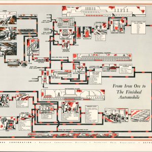
From Iron Ore to The Finished Automobile
$100.00 Quick View -
 Sold Out
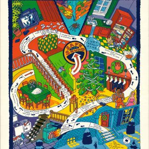
Home Alone
Quick View -

Map of Roseau County Minnesota
$200.00 Quick View -
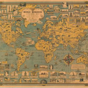
World Wonders A Pictorial Map
$150.00 Quick View -
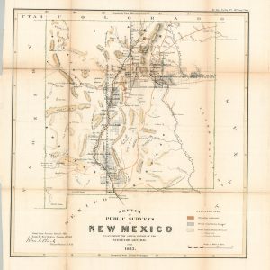
Sketch of the Public Surveys in New Mexico
$250.00 Quick View -
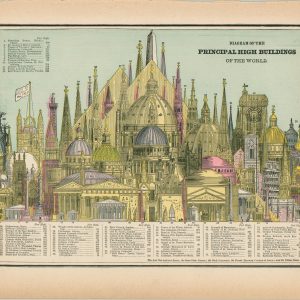
Diagram of the Principal High Buildings of the World
$50.00 Quick View -
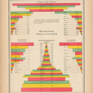
The Military Power of the World
$35.00 Quick View -

Ohio
$75.00 Quick View -

When Did Women Dress Their Hair Like That? Examples of 1,000 Years
$60.00 Quick View -

American Political Parties
$45.00 Quick View -
![[Set of Five Paper Catalogs]](https://curtiswrightmaps.com/wp-content/uploads/DSC_2648-300x300.jpg)
[Set of Five Paper Catalogs]
$125.00 Quick View -
 Sold Out
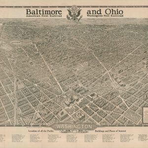
Washington The Beautiful Capital of the Nation
Quick View -
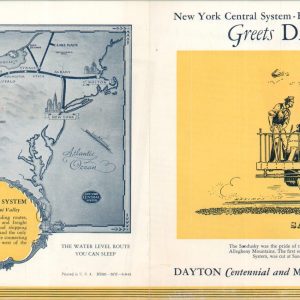
The New York Central System A Railroad of the Dayton and Miami Valley
$40.00 Quick View -
![Map of the Territorial Divisions of the Aborigines of New York [and] Map of the Early and Recent Sites of the Aborigines of New York](https://curtiswrightmaps.com/wp-content/uploads/Inv008259-300x300.jpg)
Map of the Territorial Divisions of the Aborigines of New York [and] Map of the Early and Recent Sites of the Aborigines of New York
$95.00 Quick View -
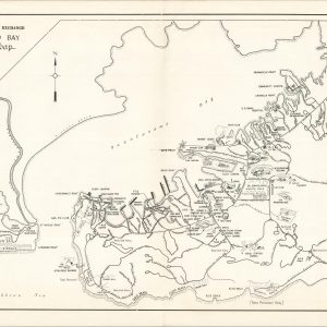
Guantanamo Bay Visitors Map
$95.00 Quick View -
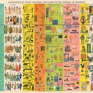
An Illustrated Chart Showing 5,000 Years of the History of Mankind
$125.00 Quick View -
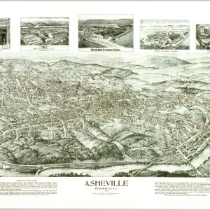
Asheville Buncombe Co. N.C.
$35.00 Quick View -

The Dymaxion Air-Ocean World
$800.00 Quick View -
![Scouting's Safari 1984 Scout-O-Rama [Brookfield Zoo, Illinois]](https://curtiswrightmaps.com/wp-content/uploads/map_30.78x21.93_02-17-26_inv008254c-300x300.jpg)
Scouting’s Safari 1984 Scout-O-Rama [Brookfield Zoo, Illinois]
$75.00 Quick View -

The City of Berwyn
$75.00 Quick View -
![Plan Your Vacation on this Flagship Map [American Airlines]](https://curtiswrightmaps.com/wp-content/uploads/map_12.69x14.23_02-17-26_inv008252jpgc-300x300.jpg)
Plan Your Vacation on this Flagship Map [American Airlines]
$50.00 Quick View -
![[Five Cartographic Political Handbills]](https://curtiswrightmaps.com/wp-content/uploads/map_8.53x11.14_02-17-26_inv008251c-300x300.jpg)
[Five Cartographic Political Handbills]
$400.00 Quick View -
![[Brodhead High School Commencement Program]](https://curtiswrightmaps.com/wp-content/uploads/map_5.27x8.17_02-17-26_inv008250c-300x300.jpg) Sold Out
Sold Out[Brodhead High School Commencement Program]
Quick View -

The Kanawha and Michigan Ry Plan Showing Yard Layout of Dickinson, West Virginia
$875.00 Quick View -
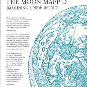
The Moon Mapp’d Imagining a New World
$50.00 Quick View -
![[Map and Print Block of the 102nd Infantry Division]](https://curtiswrightmaps.com/wp-content/uploads/map_12.07x16.16_02-17-26_inv008248c-300x300.jpg)
[Map and Print Block of the 102nd Infantry Division]
$2,500.00 Quick View -
 Sold Out
Note Book For Constructive Work in Geography
Quick View -
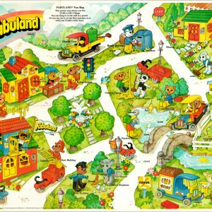
Fabuland Fun Map
$350.00 Quick View -
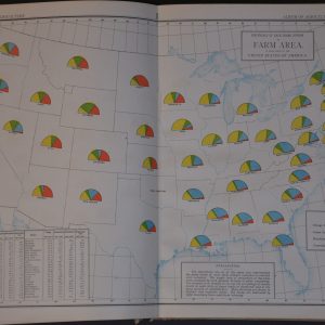
Album of Agricultural Statistics
$275.00 Quick View -
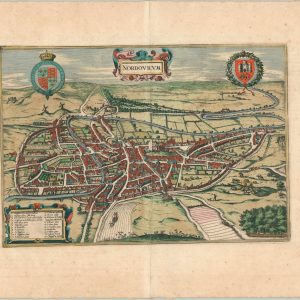
Nordovicum
$295.00 Quick View -
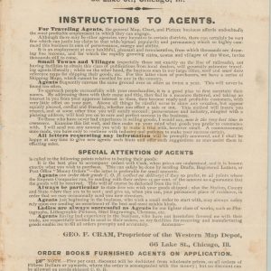 Sold Out
New Descriptive Price List of Popular Maps, Charts, Lithographs, Photographs, Steel Engravings, Framed Pictures…
Quick View -
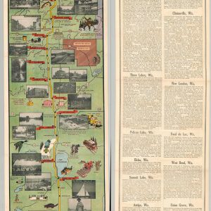
Wisconsin U.S. Highway 45 Lake Superior to the Gulf of Mexico
$325.00 Quick View -

The Islands of Hawaii
$250.00 Quick View -

San Francisco and Vicinity issued by the Southern Pacific
$500.00 Quick View -
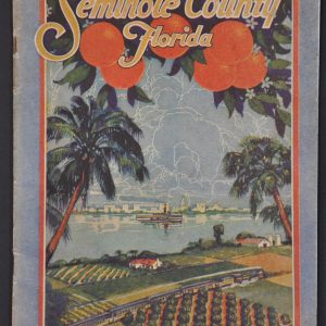
Seminole County Florida
$600.00 Quick View -
![[Chicago's Coming Factory Suburb - Columbian Exposition Promotion for Griffith, Indiana]](https://curtiswrightmaps.com/wp-content/uploads/map_21.05x29.19_02-17-26_inv008238c-300x300.jpg)
[Chicago’s Coming Factory Suburb – Columbian Exposition Promotion for Griffith, Indiana]
$900.00 Quick View -
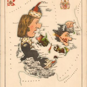
Denmark
$375.00 Quick View -
 Sold Out
Armchair General
Quick View -
![A Map of New-England [1826 reprint]](https://curtiswrightmaps.com/wp-content/uploads/map_18.13x12.95_02-17-26_inv008233.1c-300x300.jpg)
A Map of New-England [1826 reprint]
$300.00 Quick View -
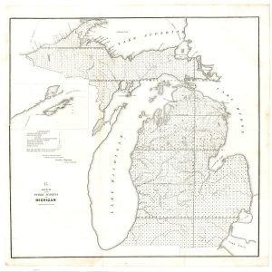
Sketch of the Public Surveys in Michigan
$200.00 Quick View -
![[Collection of Plain Maps by Abbe Gaultier]](https://curtiswrightmaps.com/wp-content/uploads/map_14.67x18.46_02-17-26_inv008231c-scaled-e1771952133537-300x300.jpg)
[Collection of Plain Maps by Abbe Gaultier]
$295.00 Quick View -
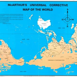
McArthur’s Universal Corrective Map of the World
$395.00 Quick View -

The World…Their Battleskies
$80.00 Quick View -

Chocolate and Cocoa Nourishing Foods
$495.00 Quick View
show blocks helper