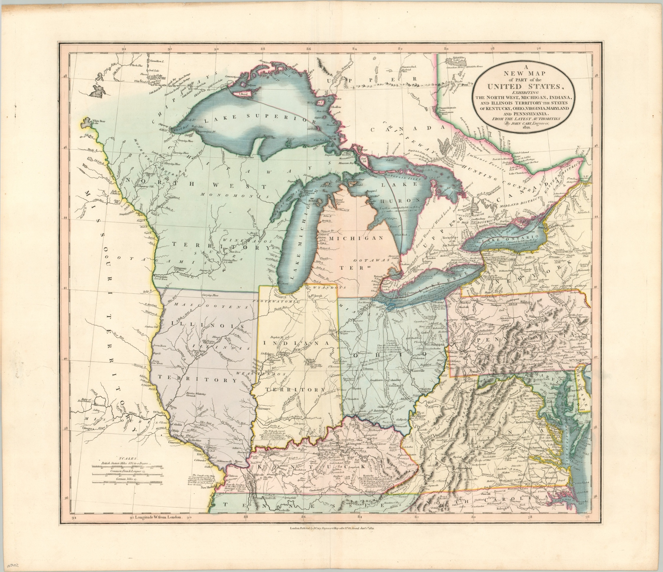
A New Map of Part of the United States, Exhibiting the North West…
Wonderfully detailed map of the former Northwest Territory.
Out of stock
Description
Established in 1787 by an act of the newly formed Congress of the Confederation, the Northwest Territory was the nation’s first post-colonial organized incorporated territory. Though the land would ultimately encompass the majority of six states, in the early 19th century it represented the frontier of fledgling America. This map, issued in 1821, shows an important step in the process of transitioning from the unincorporated territory into official states of the Union.
The borders of Ohio, Michigan, Indiana, Illinois, Wisconsin, and Minnesota all require further development before their outlines correspond to our modern-day equivalent. Of particular interest is the border between the Michigan Territory and Ohio. After the bloodless ‘Toledo War’ of 1835-36, a strip of land was ultimately acceded to the latter in exchange for the entirety of the Upper Peninsula.
Furthermore, Illinois does not extend far enough north to encompass Chicago, which is identified only as (the second) Fort Dearborn. Despite it officially ceasing to exist with Ohio’s statehood in 1803, the remnants of the Northwest Territory can be seen comprising the eventual states of Wisconsin and Minnesota. The Missouri Territory encompassed everything west of the Mississippi River acquired from France in the Louisiana Purchase.
Apart from showing a fascinating and temporary outline of the Midwest, the map also presents a wealth of contemporary details within its image. Primary roads, some of which may have been planked, are shown connecting the relatively disparate settlements of the West. Numerous fortifications and Native American villages are labeled throughout, along with geographic features, battle sites, and more.
Several annotations provide additional information and often cite a source, possibly in an attempt to add authority to the data and thus the entire production. Examples include the length of the Ohio River, the navigability of other waterways, the size of the Great Lakes, and Daniel Boone’s explorations in Kentucky.
The map was engraved and published in London by John Cary in 1821 as part of his New Universal Atlas.
Map Details
Publication Date: 1821
Author: John Cary
Sheet Width (in): 24.40
Sheet Height (in): 21.00
Condition: A
Condition Description: A fantastic example of this scarce map in fine hand color. Lightly creased adjacent to the vertical centerfold, with a faint spot near the bottom visible in the publisher's imprint. Very faint offsetting from the title in the upper left, hardly noticeable. The upper left margin is toned and worn, but only about a quarter-inch into the sheet. Contemporary manuscript page numbering and 'United States - West' on the verso.
Out of stock