Hydrographical Basin of the Upper Mississippi River
“The earliest accurate map of the Northern Plains and the Upper Mississippi” [Rumsey]
Out of stock
Description
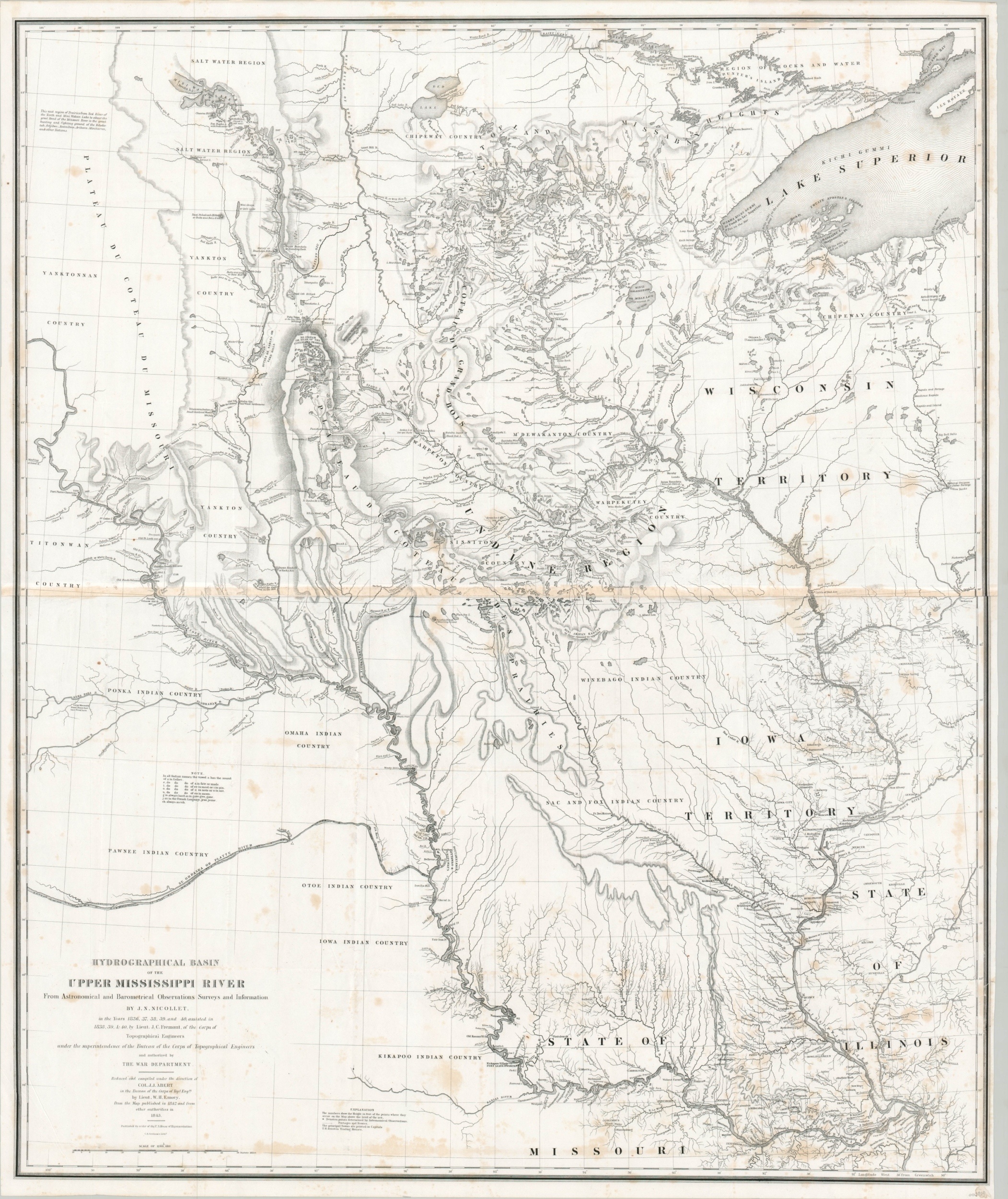
This spectacular map of the Upper Mississippi River and largely unorganized Northwest Territory represents a monumental step forward in the cartography of the region. The image includes a broad area from St. Louis to Lake Superior and the Lake of the Woods. To the west, much of the land is labeled as Indian Country and the course of the Platte and Missouri Rivers are shown to approximately 100 degrees west of Greenwich; across modern-day Nebraska, South Dakota, and North Dakota.
As noted in the text under the title block, J.N. (Joseph Nicolas) Nicollet led three expeditions to map the Mississippi River and adjacent regions between 1836 and 1839 and was assisted in his endeavors by a representative of the War Department in John C. Fremont. A former astronomer and mathematics professor, the French emigre applied a level of precision never before seen in frontier surveying, Over a hundred different points within the image represent a spot where astronomical calculations were taken, requiring the transportation of bulky equipment the preservation of invaluable notes and papers across the terrain. Details down to minute streams and tributaries are engraved with delicate lines and the use of hachuring to depict topography is an early example in official American cartography. Elevations and geographic formations are also labeled within the image.
The map “initiated the scientific mapping of the trans-Mississippi West by the War Department” [Schwarz & Ehrenberg] and this included the recording and preservation of indigenous place names on an unprecedented scale. Dozens of toponyms are given in both European and Native American languages, with an annotation in the center left providing clues on the often difficult pronunciation. While this appears to validate and authentic the presence of indigenous people, the official policy of the Indian Removal Act of 1830 gave broad authority for local governments to persuade tribes to relocate.
The map is in one of its two states issued for Congress, as noted by the “Published by order of the U.S. House of Representatives” below the date. It was designed by William H. Emory based on the observations of Nicolett and Fremont and under the authority of Colonel J.J. Abert of the Army Bureau of the Corps of Topographic Engineers. Published in Washington, D.C. in 1843 as part of Nicolett’s official report.
Sources: Schwartz & Ehrenberg, p. 267-268; Wagner-Camp, 98; Rumsey 2488.001
Map Details
Publication Date: 1843
Author: Joseph Nicollet
Sheet Width (in): 30.75
Sheet Height (in): 37
Condition: B
Condition Description: Two sheets, joined along a vertical seam that's moderately toned from the adhesive. Moderate spotting throughout, but concentrated near the bottom of the lower sheet. Otherwise in very good condition, with a crisp impression on bright paper
Out of stock