[Set of Five Station Maps – Track & Structures Grand Rapids & Indiana Railway Northern Division]
$450.00
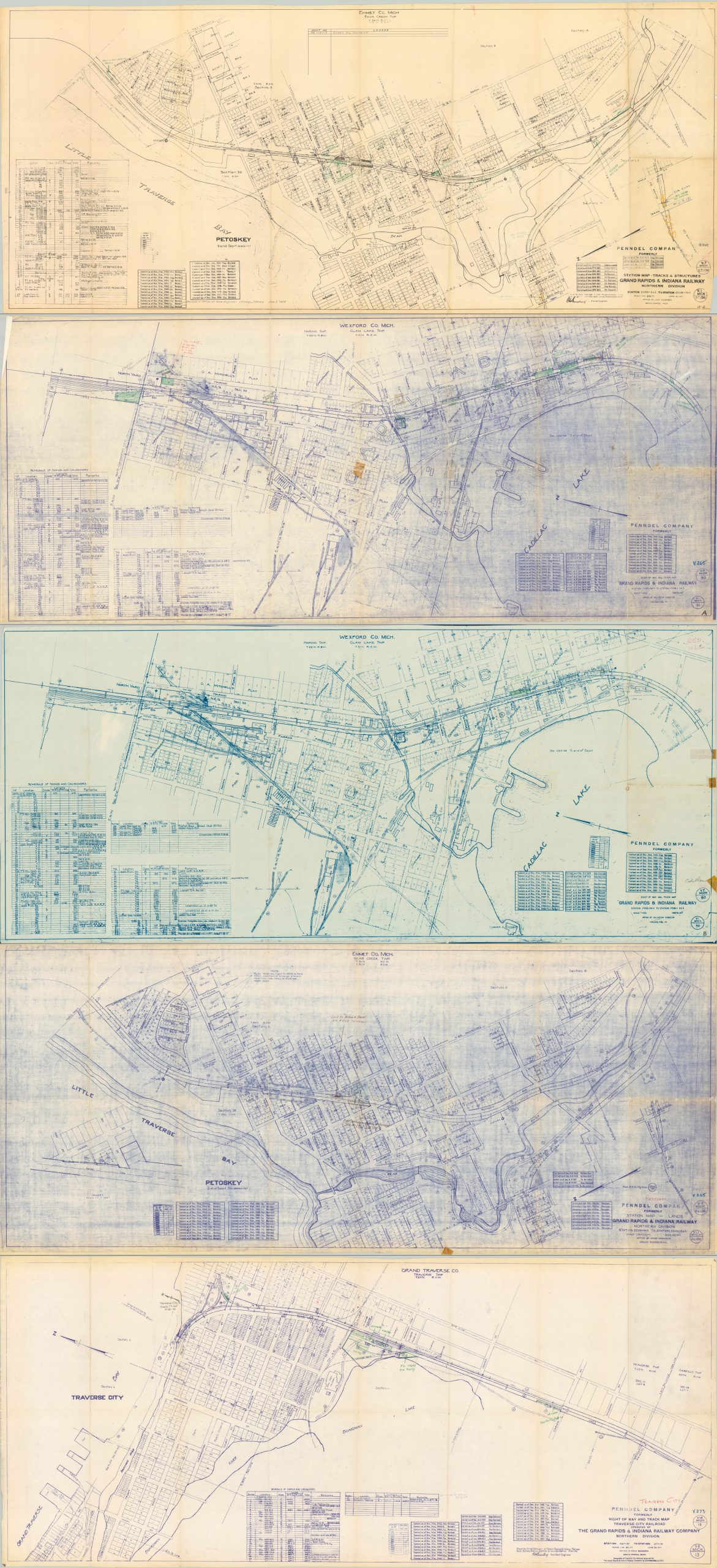
Three Michigan towns along the lines of the Grand Rapids & Indiana Railway.
1 in stock
![[Set of Five Station Maps - Track & Structures Grand Rapids & Indiana Railway Northern Division] - Image 2](https://curtiswrightmaps.com/wp-content/uploads/map_24.45x56.43_07-15-24_inv006295.3c-1-scaled.jpg)
![[Set of Five Station Maps - Track & Structures Grand Rapids & Indiana Railway Northern Division] - Image 3](https://curtiswrightmaps.com/wp-content/uploads/map_26.17x55.56_07-15-24_inv006295.1c-scaled.jpg)
![[Set of Five Station Maps - Track & Structures Grand Rapids & Indiana Railway Northern Division] - Image 4](https://curtiswrightmaps.com/wp-content/uploads/map_26.53x56.49_07-15-24_inv006295.4c-scaled.jpg)
![[Set of Five Station Maps - Track & Structures Grand Rapids & Indiana Railway Northern Division] - Image 5](https://curtiswrightmaps.com/wp-content/uploads/map_26.55x56.79_07-15-24_inv006295c-scaled.jpg)
![[Set of Five Station Maps - Track & Structures Grand Rapids & Indiana Railway Northern Division] - Image 6](https://curtiswrightmaps.com/wp-content/uploads/map_28.55x56.39_07-15-24_inv006295.2c-1-scaled.jpg)
Description
This interesting and rare collection of railroad plans show the tracks of the former Grand Rapids & Indiana Railway through three different Michigan towns – Traverse City, Petoskey, and Cadillac. Each city lies along the route of the railway, originally chartered in 1854 to connect Cincinnati to the Straits of Mackinac. A branch to Traverse City in the early 1870s encouraged emigration to that area, and by the late 1890s, the railroad was one of the largest north-south routes in the country – greatly facilitating development in northern Michigan.
The images highlight company property (then a subsidiary of the Pennsylvania Railroad) and trackage right of way through several square blocks of each downtown district. Handwritten notes reflect the maps’ status as working documents, used and updated regularly. The revisions are carefully noted by date, with the latest being December 1966.
Publication is attributed to the Penndel Company, a holding company created by the Pennsylvania Railroad to legally own and operate various lines throughout the Midwest. Less than a decade later, the remnants of the Grand Rapids & Indiana Railway were acquired by the Michigan Department of Transportation and mostly mothballed. However, a portion of the route between Cadillac and Petoskey is still in operation by the Great Lakes Central Railroad.
Map Details
Publication Date: 1961 - 1966
Author: Penndel Company Office of Valuation Engineer
Sheet Width (in): 56.25
Sheet Height (in): 24.25
Condition: B+
Condition Description: Group of five photomechanically replicated sheets (two duplicates) with noted revisions through the mid to late 1960s. Several vertical creases where previously folded and a handful of old cellophane tape repairs. Scattered manuscript annotations in a few areas. Overall in good to very good condition.
$450.00
1 in stock