Phelps & Ensign’s Travellers’ Guide, and Map of the United States
Original price was: $1,500.00.$1,200.00Current price is: $1,200.00.
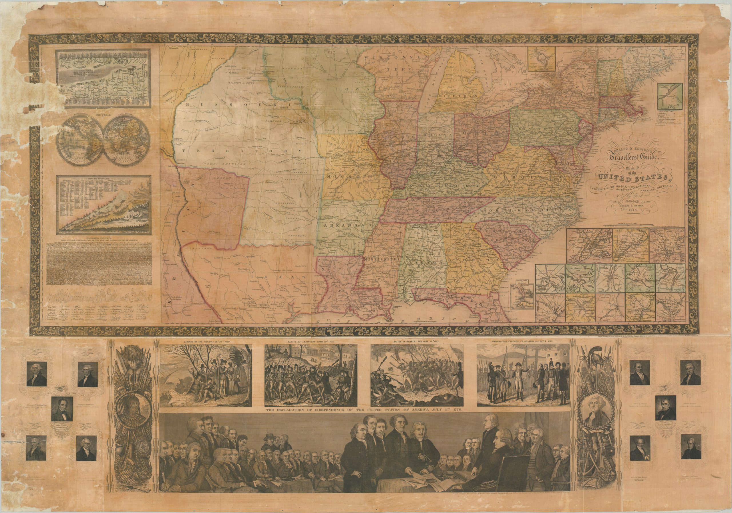
Beautifully decorative wall map of the United States east of the Rocky Mountains.
1 in stock
Description
This eye-catching map of the United States presents the nation marching ever westwards, just a few years before conflict with Mexico erupts and further enlarges the country.
East of the Mississippi River, a robust transportation network of roads, canals, and railroads can be seen connecting many of the major towns and small settlements. Distances between points are often noted, providing a valuable reference for the potential traveler. As one ventures west, roads and villages become scarce, with numerous Native American tribes occupying much of the Missouri Territory and ‘The Great American Desert’ separating U.S. from Mexican Territory. To the south, the fledgling Republic of Texas is depicted with its borders at the Rocky Mountains and Rio del Norte (undoubtedly to Mexico’s chagrin).
Inset plans in the lower right show many of America’s important ports and harbor cities, including New York, Boston, Philadelphia, Mobile, New Orleans, and St. Louis. The inclusion of Chicago (pop. ~ 7,000) presages the city’s future relevance as a shipping and transportation depot. The bottom of the sheet is occupied by several scenes celebrating American political history. Several notable battles, presidential portraits, and the signing of the Declaration of Independence have been skillfully executed. The entire text of the latter has even been legibly replicated in the center-left, along with the ‘John Hancocks’ of its signers.
Engraved on steel by J. Wells. Published in New York in 1842 by Humphrey Phelps and Edward Ensign. A version of the map was first issued in 1839 and re-published through the late 1850s, offering a detailed overview of the nation’s growth during the mid-19th century.
Map Details
Publication Date: 1842
Author: Phelps & Ensign
Sheet Width (in): 41.4
Sheet Height (in): 28.6
Condition: B
Condition Description: Professionally cleaned, repaired, and mounted onto fresh and new Japanese tissue. Some image loss from the restoration, most evidently in the upper left corner, with the double-hemisphere and river diagrams moderately affected. Several other small chips around the outer edges of the sheet. Small holes at the top and bottom where formerly affixed to the rollers (now gone). Minor discoloration visible within the map, most evident in the Iowa and Missouri Territories. About good condition overall.
Original price was: $1,500.00.$1,200.00Current price is: $1,200.00.
1 in stock