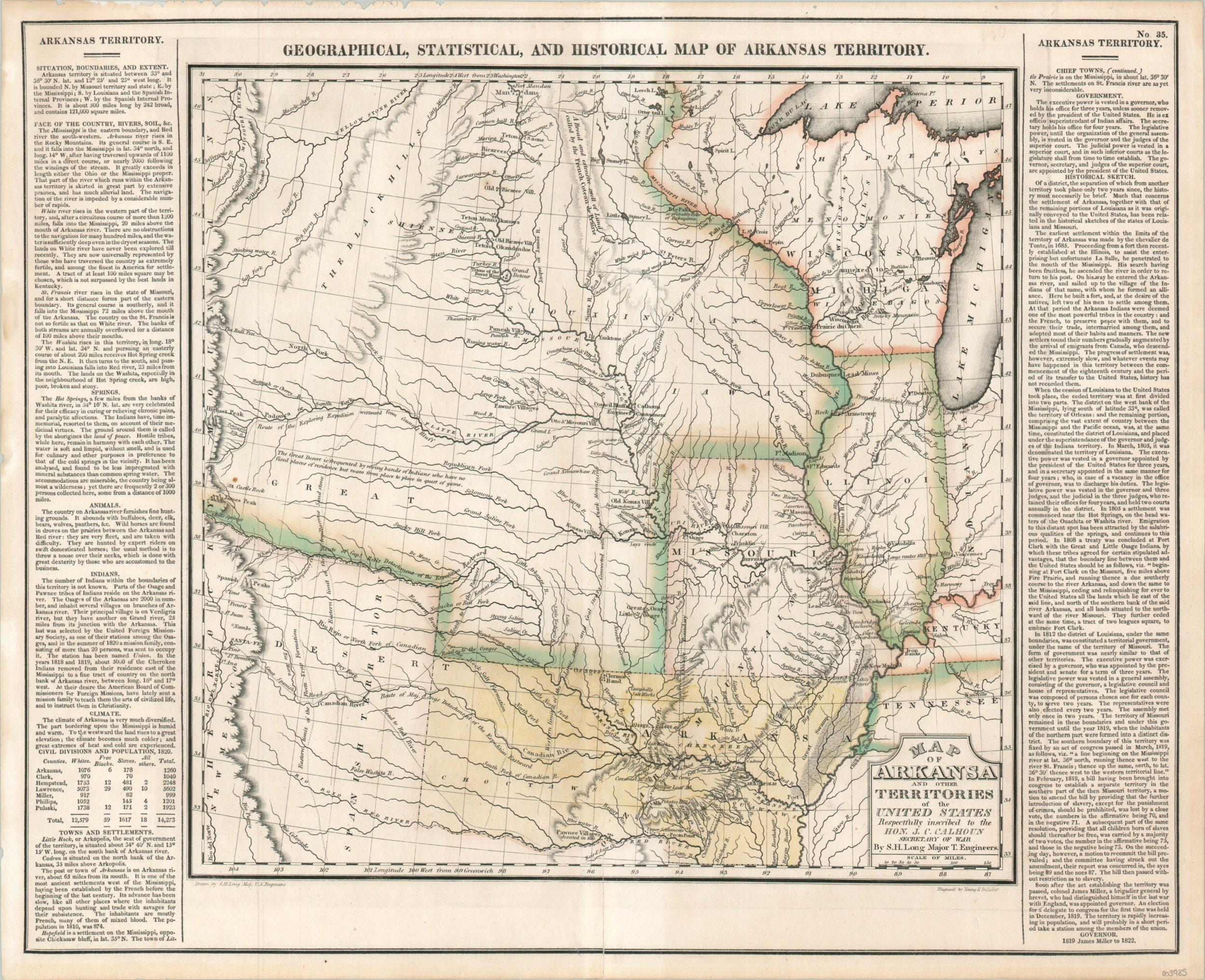
Map of Arkansas and Other Territories of the United States
Stephen Long’s seminal map of the western frontier of the United States.
Out of stock
Description
In 1822, Henry Charles Carey and Isaac Lea published their A Complete Historical, Chronological, and Geographical American Atlas. The sheets from this atlas, which cover North America, Central America, South America, and the West Indies, are comprised of an engraved map surrounded by text documenting the history, climate, population, and other information about the area depicted. The atlas is particularly known for its excellent early maps of the states and territories of the United States, less than fifty years old around the time of publication.
The most influential and important map in the atlas was this one of the Arkansas Territory, a seminal map in the cartography of the trans-Mississippi West and the Louisiana Purchase north of Louisiana. The map was originally based on a manuscript map drawn by Stephen Long in 1821, the first to show the results of his important exploration of the American West from 1819-1820. It appeared a year before Long’s official report and the map contained therein, making it one of the few examples of a commercial publication issued prior to the explorer’s volume.
During his expedition, Long explored the region between the Missouri River and the Rocky Mountains, including the Platte, Red, and Canadian Rivers and the resulting map is a precise statement regarding his travels. Carey & Lea’s map was praised by Carl Wheat as a distinct step forward in mapping the American West. It includes an early depiction of the Arkansas Territory, extending from the Mississippi River to the Spanish territory of New Mexico, and is one of the first printed maps to show Missouri as a state (1820). Long explored along the South Branch of the Platte River, shown here for the first time, and he depicts the earliest representation of Long’s Peak, labeled ‘Highest Peak’ within the image. Members of Long’s party, including Dr. Edwin James, were the first to successfully ascend Pike’s Peak. Long named the mountain “James Peak” after the doctor, but the name never stuck and would remain affixed with Zebulon Pike. As described by the University of Tulsa;
“One of the map’s most notable features and a source of its enduring power was the label “GREAT AMERICAN DESERT” Long used in describing the American Great Plains (“GREAT DESERT” in the Carey and Lea Atlas). As Long’s party traveled across what is today the High Plains area of southwest Kansas, the Texas Panhandle and western Oklahoma in the heat of July and August of 1820, what they saw and endured would have certainly seemed a “desert” to men of the East.
The delineation of the area as a desert, unsuitable for sustainable agriculture such as was known to Long, a man from New Hampshire, illustrates how the expectations Americans had for the West were turned upside-down when confronted with its realities. The western Plains were not the farmer’s garden or paradise as imagined by Thomas Jefferson; the area was exceedingly arid with unbroken grasslands compared to the wet, green and timbered east. For many in the nation, Long’s notation that “The Great Desert is frequented by roving bands of Indians who have no fixed places of residence but roam from place to place in quest of game” defined the area. This was a home for nomadic Indians and a buffer against rival empires.”
Sources: Wheat 348; University of Tulsa; Antiques Roadshow
Map Details
Publication Date: 1822
Author: Stephen Long
Sheet Width (in): 20.75
Sheet Height (in): 16.5
Condition: A
Condition Description: Light wear along vertical centerfold and one small tear in the lower margin has been repaired on the verso with archival tape. One faint damp stain in the upper left corner that just enters the plateline and some minor paper loss in the upper margin. Very good to near fine overall, with attractive original outline color.
Out of stock