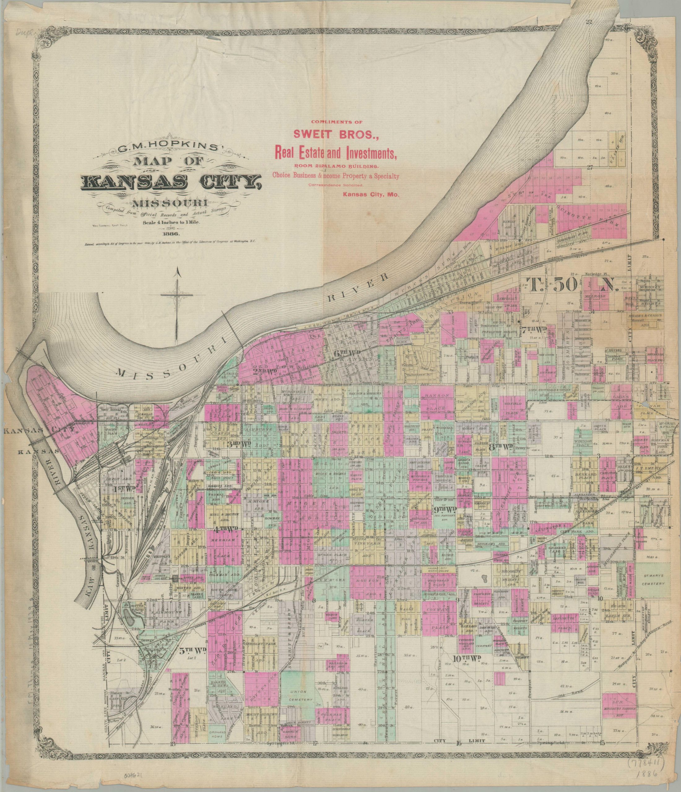
G.M. Hopkins’ Map of Kansas City, Missouri
$1,350.00
A rare city plan of Kansas City from the mid-1880s.
1 in stock
Description
This engaging Gilded Age street plan of Kansas City, Missouri, was designed and copyrighted in 1886 by G.M. Hopkins, head of an influential Philadelphia-based civil engineering firm. The detailed image, engraved by Mac Cormac, features vibrant red overprinting (a feature not found on all examples), indicating its distribution by Sweet Brothers Real Estate and Investments, then located in Kansas City’s Alamo Building.
The map captures the city during a spectacular metamorphosis, as it sheds its frontier identity to become a sophisticated industrial powerhouse. The recent introduction of the refrigerated railcar is reflected in the massive footprint of the West Bottoms stockyards, while a robust network of early transit lines showcases one of the world’s most advanced public systems. Notable landmarks include the 9th Street Incline, a cable car trestle completed just a year prior in 1885, and the 5th Street test track where entrepreneur John C. Henry debuted the world’s first overhead “trolley” system. Both these experimental lines and the more established Westport Route are clearly delineated.
Beyond its economic focus, the map serves as a meticulous catalog of the city’s physical expansion. Dozens of hand-colored subdivisions and “Additions” radiate from the central hubs of Old Town and East Kansas City. Surnames such as McGee, Guinotte, Coates, and McCoy pepper the grid, representing the influential families whose speculative investments defined the urban development of the era. The details also served as visual proof to potential investors that all parts of the city were ‘filling in’, actively marketing the opportunity to an Eastern audience. The map is quite rare and listed only twice in WorldCat as of April 2026 – at the Newberry Library and the University of Missouri-Kansas City. Two additional copies have been located in the collections of the Kansas City Public Library.
Sources: Kansas City Historical Society; OCLC #753565300
Map Details
Publication Date: 1886
Author: G.M. Hopkins
Sheet Width (in): 19.00
Sheet Height (in): 21.75
Condition: B
Condition Description: Steel engraved map with original hand color (probably applied with stencil) printed on a somewhat thin sheet of paper. Moderate toning visible along the outer edges, most evident on the left and right side (both trimmed to the plateline, as issued). Further discoloration and soiling in the upper right. Creasing along old folds and some extraneous wrinkling present in the upper center. Finally, a few closed tears repaired on the verso with archival tape, though with minimal loss. Despite the litany of defects, the map remains intact and eminently legible, with bright color and a full image.
$1,350.00
1 in stock