Carte de la Louisiane et du cours du Mississipi dressée sur un grand nombre de mémoires entrautres sur ceux de Mr. le Maire, par Guillaume De l’Isle
$850.00
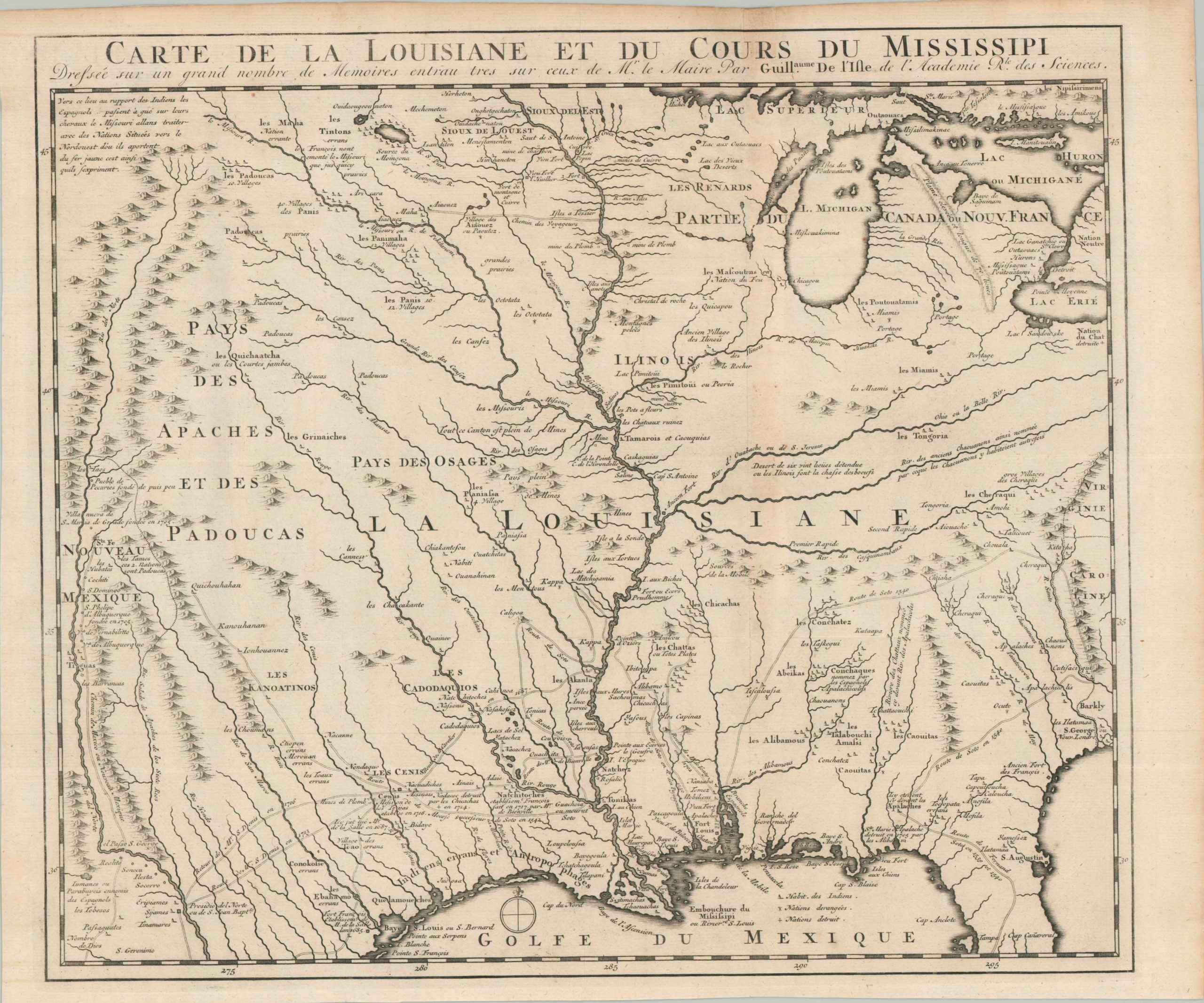
A reduced version of Delisle’s landmark map of French territory in North America.
1 in stock
Description
Guillaume Delisle’s landmark 1718 Carte de la Louisiane is widely regarded as one of the most significant and influential maps of North America ever produced. As the official Geographer to the King of France, Delisle introduced a new level of scientific rigor to the mapping of the New World, utilizing astronomical observations to correct the myriad of errors that had plagued earlier charts. The 1718 original is celebrated for several “cartographic firsts,” most notably providing the first accurate rendering of the Mississippi Delta and the first appearance of the name “Texas” (Mission de los Teijas) on a printed map.
This particular iteration of the Delisle survey, published around 1730, represents a specialized, reduced version of the 1718 landmark map, specifically designed to highlight the vast interior of French Louisiana. It was created by Jean Frederic Bernard and likely issued in his important work, Relations de la Louisiane et du Fleuve Mississipi.
Unlike the larger folio editions that offer a continental overview, this version strategically omits the British-controlled East Coast, focusing instead on the immense territory stretching from the Great Lakes to the Rio Grande. By centering the composition on the Mississippi Basin and the Gulf of Mexico, the map functions as a “regional manifesto,” presenting Louisiana as a self-contained empire, far surpassing its European rivals like Britain and Spain.
The image presents a detailed overview of the largely unknown heartland of America during the early 18th century. The mighty Mississippi River cleanly bisects the territory in the center, with numerous branches (some real, other ficticious) providing some of the only navigable paths into the rugged interior. Dozens of Native American villages are labeled (represented with small triangles), while less common European settlements and fortifications are depicted with tiny squares. In addition to the aforementioned Texas mission, other interesting labeled features include Chicagou, the route of de Soto’s expedition (clearly supplanted by later French claims), and cautionary ‘man-eating Indians’ along the Gulf Coast.
Map Details
Publication Date: c. 1730
Author: Jean Frederic Bernard
Sheet Width (in): 17.40
Sheet Height (in): 14.40
Condition: B+
Condition Description: Copperplate engraved sheet on a formerly folded sheet of laid paper. Some light creasing and faint wear along the former backing strip, most evident in the upper right, were a small damp stain affects the title block. Irregular trimmed margins and small pieces of archival tape on verso, were previously framed. Good to very good condition overall.
$850.00
1 in stock