
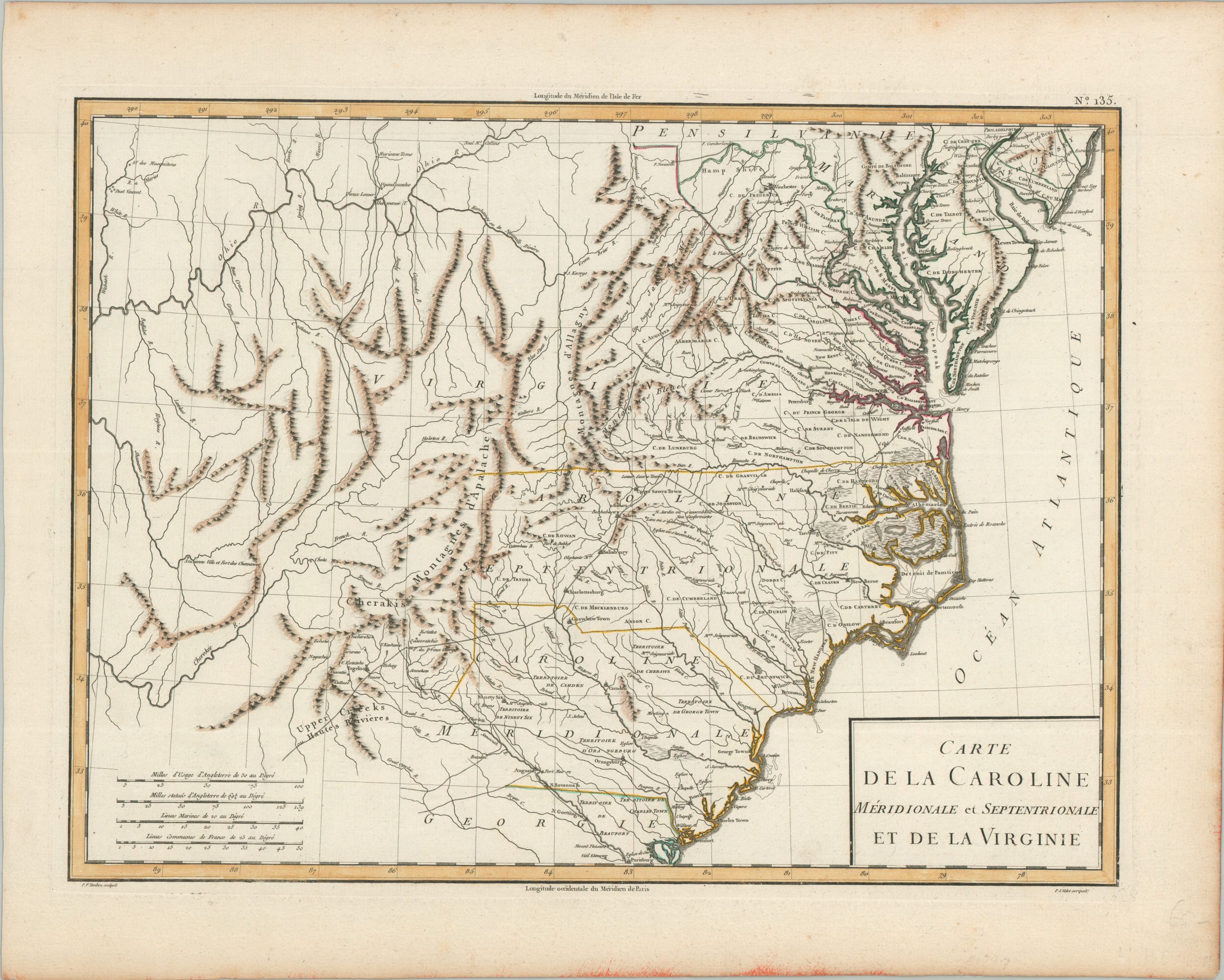
Carte de la Caroline Méridionale et Septentrionale et de la Virginie
$500.00
A French view of Virginia and the Carolinas in the early years of the American republic.
1 in stock
Description
This finely engraved French map of the American Southeast extends from Philadelphia and Delaware Bay south to the mouth of the Savannah River, and west across the Appalachians to the Wabash. Although it was issued about two decades after American independence, its geography looks back to the British surveys of the colonial era. Virginia’s name stretches clear across the mountains with no sign of Kentucky or Tennessee, South Carolina is still divided into its seven pre-war districts (labeled here as ‘Territoires’), Charleston appears as ‘Charles Town,’ and North Carolina’s short-lived Tryon County, abolished in 1779, remains in place.
The settled tidewater and piedmont are crowded with counties, towns, roads, churches, chapels, and manor houses. In the North Carolina backcountry, the Moravian settlements of Salem, Bethabara, and Bethania are joined by notes locating the meeting places of nearby Quakers and ‘Non Conformistes.’ Fort Necessity and Fort Cumberland appear in the upper center, recalling the opening shots of the French and Indian War. Detail thins beyond the mountains, which are shown in shaded profile, but the Cherokee towns of Keowee, Tugaloo, and Chota are all named, along with the Upper Creeks, an ‘Ancienne Ville et Fort des Chawanoes’ on the Cumberland River, and Post Vincent (Vincennes) on the Wabash.
Four distance scales fill the lower left corner and longitude is measured from both Ferro (top) and Paris (bottom). The map was engraved by Pierre François Tardieu, with lettering by P.J. Valet, and published in Paris around 1797 as plate No. 135 in Edme Mentelle and Pierre-Grégoire Chanlaire’s Atlas Universel de Géographie Physique et Politique, Ancienne et Moderne.
Map Details
Publication Date: c. 1797
Author: Pierre François Tardieu
Sheet Width (in): 19.75
Sheet Height (in): 15.9
Condition: A-
Condition Description: Copperplate engraved map with attractive hand outline color on a sturdy sheet with ample margins. Light toning at the sheet edges and a few scattered spots in the margins, including a small red stain along the bottom edge, well away from the image. Very good overall.
$500.00
1 in stock