Afghanistan N.W. Frontier Province U.S.S.R.
$975.00
Updating British maps of the ‘Roof of the World’ during the Cold War.
1 in stock
Description
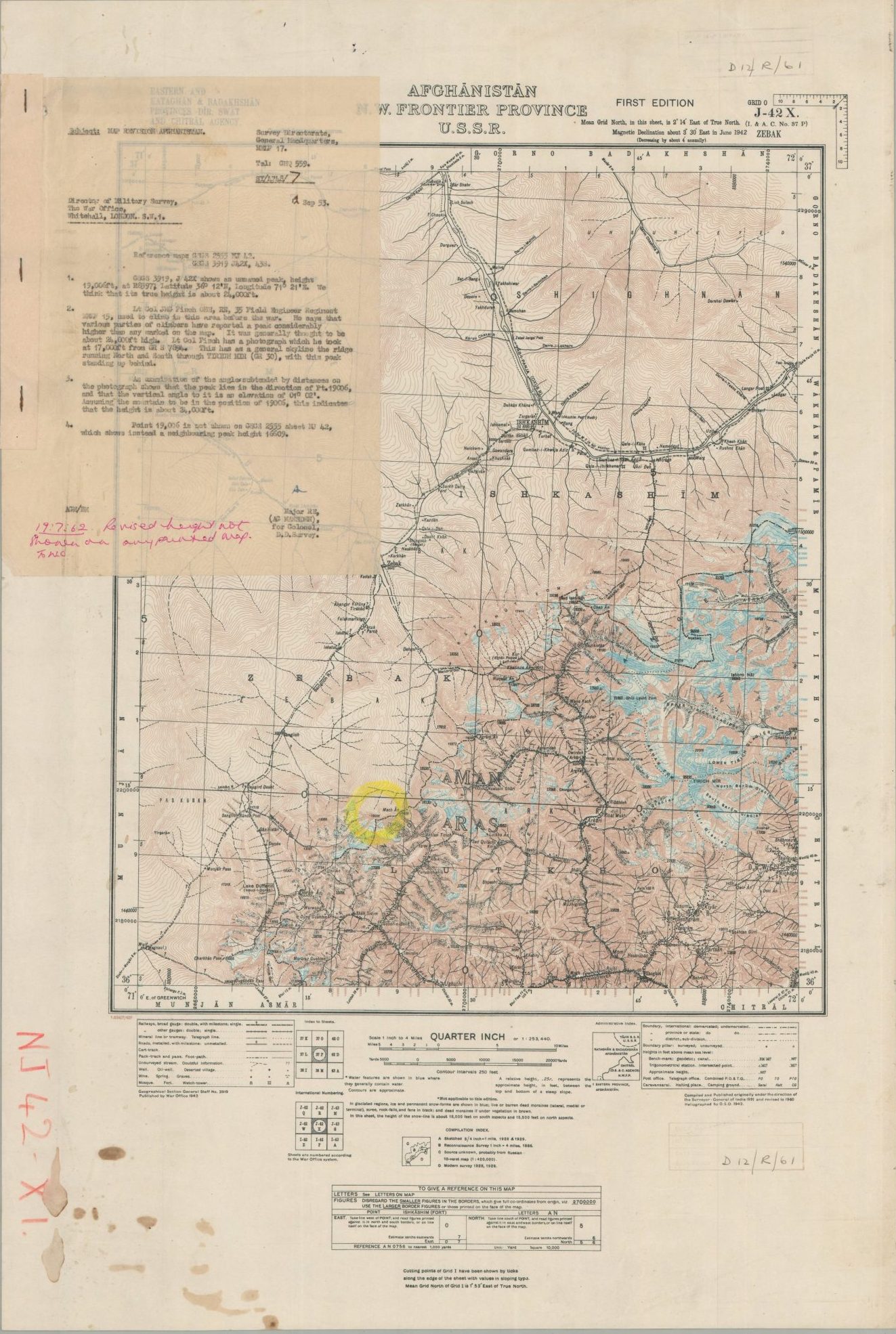
This detailed topographical map captures a large and historically disputed area around northeastern Afghanistan, northern Pakistan, and southwestern Tajikistan (an inset, lower right, gives an impression of the complex borders). The remote region, where the foothills of Central Asia transform into the formidable barrier of the Hindu Kush and Pamir mountains, represented the frontier of British authority during the colonial era, though its history along the Silk Road goes back millennia. As one of the highest mountain systems in the world, it is filled with steep ravines, glacial lakes, and breathtaking (if inaccessible) vistas.
The map was first created in 1942, using earlier surveys from 1886 – 1940, by the Geographical Section, General Staff of the British War Office. During World War II, the Hindu Kush and Pamir mountains formed a remote, ill-defined boundary at the intersection of British and Soviet influence. The image represents significant efforts by the British to better comprehend local geography, with dozens of survey pillars and data points scattered throughout. National and local boundaries are shown (notably, a portion of the Durand Line), as well as transportation routes (ranging from railways to footpaths), waterways, mines, buildings (including caravansarais), and more.
This particular example of the map has one unnamed mountain, east of Sanglich, circled in bright yellow. This markup is detailed further in an attached letter, dated September 12, 1953, to the War Office’s Director of Military Surveys. It explains that a soldier from the 35 Field Engineer Regiment, who ‘used to climb in this area before the war’, reports that the mountain in question is closer to 24,000 ft. (rather than the reported 19,000). It appears Lt. Col. Finch may have been incorrect, as a handwritten addendum, dated 1962, reads “revised height not shown on any printed map.”
From an exhaustive search using Google Maps, it appears the original height was indeed accurate. The unnamed peak on the Afghanistan/Pakistan border is most likely Kohe Goybaz, clocking in at 5,720 m. The timing of the communications and geographic re-examination of the region is also notable. The Cold War brought renewed interest in the Hindu Kush as the Soviet Union and Western powers jockeyed for influence; each offering extensive economic aid, technical training, and infrastructure project support. Dorah Pass, labeled in the lower left (not far from the circled mountain) would play a critical role in the 1979 Soviet invasion of Afghanistan.
Map Details
Publication Date: 1942
Author: Geographical Section, General Staff
Sheet Width (in): 18.9
Sheet Height (in): 28
Condition: B+
Condition Description: Color lithographed sheet with a mimeographed letter stapled to the upper left. Heavy spotting (coffee stains?) in the lower left margin and a bit of light spotting elsewhere. Several annotations and rubberstamps throughout and the sheet is a bit wrinkled, but overall in good to very good condition.
$975.00
1 in stock