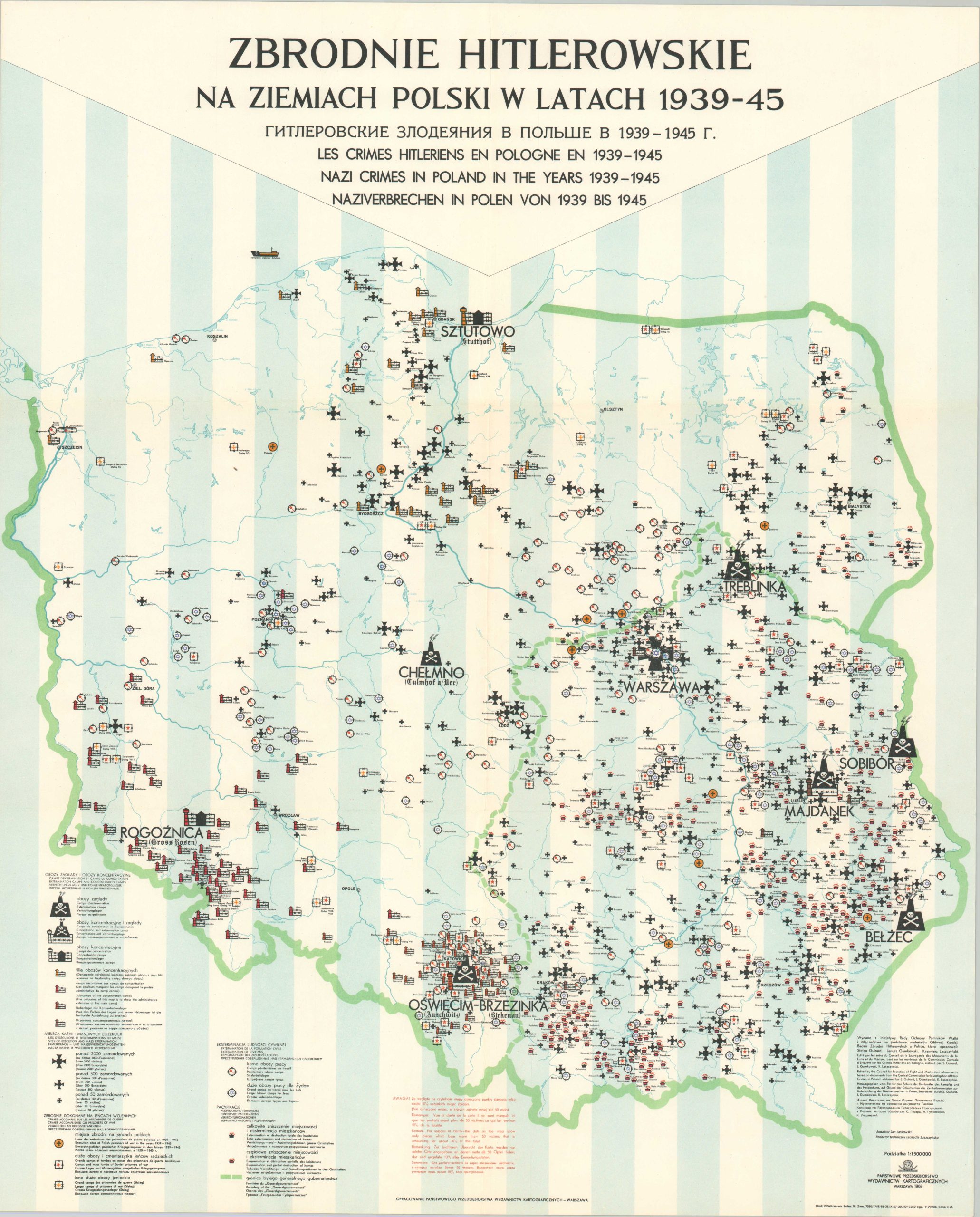
Zbrodnie Hitlerowskie na Ziemiach Polski w Latach 1939-45
$1,400.00
Documenting the Holocaust in Poland.
1 in stock
Description
This heart-wrenching map attempts to outline the extent of Nazi atrocities committed in Poland during World War II. Conveying the overwhelming tragedy is an impossibility with such a rudimentary medium, but the results are appalling, all the same. Scores of different facilities are identified throughout the image, detailed according to the legend in the lower left. The extermination camps of Chelmno, Treblinka, Sobibor, and Belzec are worth naming specifically – these hellish places were established specifically for the mass murder of Jewish people as part of Operation Reinhard. The vast majority of other camps, including Auschwitz-Birkenau, had portions of the facility dedicated to slave labor (indicated with barbed wire on the map).
Mass execution sites are in the shape of German Iron Crosses, the largest by far being in the capital of Warsaw. Other captured abuses include labor camps (POW, penal, Jewish), destroyed towns, mass burials, and execution sites. A vitally important caption at the bottom of the page indicates that, for legibility reasons, only about 10% of the total locations are shown – those with more than 50 victims. It’s also important to point out the heavy concentration of death in eastern Poland, an area that was traditionally more Orthodox and much closer to the border with Russia.
The map was drawn by Polish war veteran Jan Laskowski, with technical assistance from Leokadia Juszczynska. Published in Warsaw in 1968 by the Panstwowe Przedsiebiorstwo Wydawnictw Kartograficz (National Cartographic Publishing Company). Broader financial and historical support was provided by the Glowna Komisja Badania Zbrodni Hitlerowskich W Polsce (Central Commission for the Investigation of Nazi Crimes in Poland), including researchers Sefan Guirard, Janusz Gumkowski, and Kazimierz Leszczynski.
First published in 1962, with subsequent editions issued in 1968 and 1971. Wall maps and reduced formats (like this example) were issued for each, with the latter generally more readily available on the market. WorldCat notes 5 examples of the 1968 version, but the breakdown between the wall map and the poster size cannot be determined. An important distinction between this example and the 1971 edition is the later omission of the Jewish labor camps – likely to follow the Soviet-era policy of not differentiating between the dead. Atrocities ordered under Stalin are noticeably absent from all versions of the map.
Sources: OCLC# 61170894; Cornell University;
Map Details
Publication Date: 1968
Author: Jan Laskowski
Sheet Width (in): 18.5
Sheet Height (in): 23.75
Condition: A
Condition Description: Creasing and light wear along old fold lines. Near fine condition overall. Blank on verso.
$1,400.00
1 in stock

