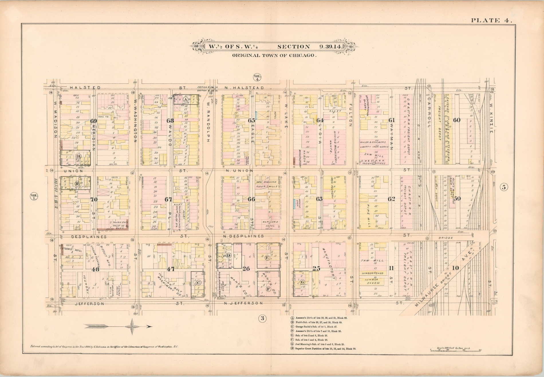
W. 1/2 of S.W. 1/4 Section 3.39.14 [Chicago]
$500.00
Map of Haymarket Square published the same year as its infamous riot.
1 in stock
Description
This fabulously detailed map of several city blocks in Chicago’s West Loop neighborhood was published in response to the devastating fire that rampaged through the city between October 8-10, 1871. Elisha Robinson, its creator, was one of the numerous publishers who issued atlases specifically for the fire insurance industry.
In order to properly assess risk, insurers needed information on building size, construction material, and the availability of water. Surveys were painstakingly performed, usually on foot, and the results are among the most complete snapshots of the city’s physical makeup in the late 19th and early 20th centuries.
This map, in theory, outlines every single building that existed at the time of publication. Color was applied by stencil and shows the construction material of each structure; pink is brick, yellow is wood, brown is stone, and blue is iron. Crosses on a building footprint indicate its use as a stable, or otherwise likely to hold combustible materials. Water and sewer lines, street elevation (which affects the flow), fire hydrants, and cisterns are also all noted.
The image is bounded by Halsted, Madison, Jefferson and Kinzie Streets, with a heavy concentration of rail tracks and Milwaukee Avenue near the top of the sheet. Like today, the area was of mixed use, though on an entirely different scale. Large freight depots (including one for Milwaukee Beer) parallel the tracks, with several sawmills and lumber yards nearby. Immediately below, a wide belt of manufacturing included an iron foundry, wagon manufactory, flour mill, bakery, machine shop, and other industries.
Haymarket Square was located along Randolph Street between Halsted and Des Plaines. It was a significant commercial corridor, with a produce market in the center of the street and numerous shops on either side. The Square was also the site of the Haymarket Riot, which took place in May of 1886, the same year the map was published. During a peaceful labor protest in support of an eight-hour workday, an alleged anarchist threw a bomb at police working to disperse the crowd. The ensuing eruption of violence resulted in the deaths of seven police (mostly friendly fire) and dozens of civilian casualties. Many of the wounded were carried to the nearby police station, labeled on the map.
As one travels further south from Haymarket, stone exteriors, luxury accommodations, and cultural opportunities become more commonplace. The Lyceum Theater, Prairie State Trust Company and Bank, and St. Denis Hotel are all labeled, with the last two bearing the characteristic markings of a luxury facade.
The map was issued as plate 4 from Volume III of Robinson’s Fire Insurance Atlas. Published in Chicago by Elisha Robinson in 1886.
Map Details
Publication Date: 1886
Author: Elisha Robinson
Sheet Width (in): 22.5
Sheet Height (in): 32.75
Condition: A-
Condition Description: Moderately soiled in the outer margins and in several places within the image, though not as to distract. Creased along vertical centerfold and a few small chips and tears from paper that has become somewhat brittle from age. Remains in very good condition overall.
$500.00
1 in stock

