
Turkey at the Crossroads
$300.00
Trying to tip the balance with Turkish neutrality during World War II.
1 in stock
Description
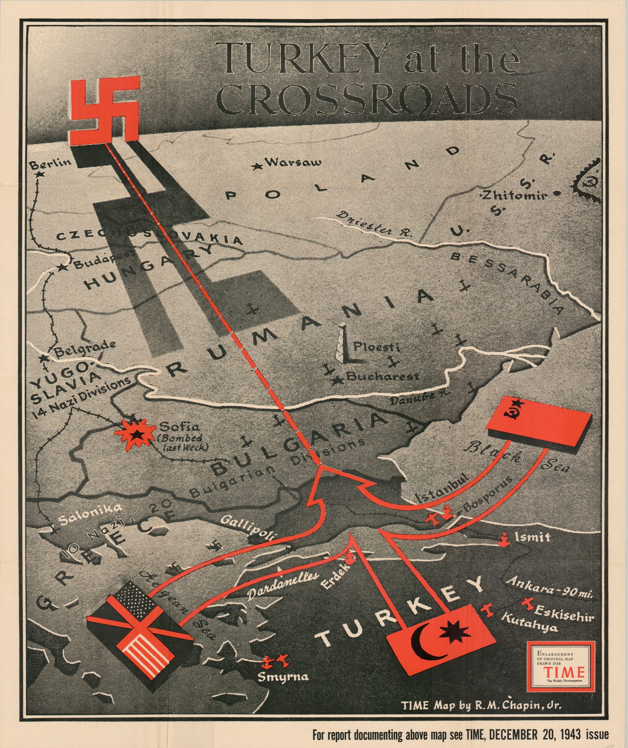
This graphic poster map presents the Bosporus and Dardanelles as a possible avenue for the Allied invasion of the Third Reich. Russian, Anglo-American, and Turkish forces are shown uniting in a common assault across the strategically important waterway, crossing into the Balkans which are overshadowed by a large swastika. Important facilities like airbases and the oilfields near Ploesti are shown pictorially. There was only one issue with the compelling image – Turkey was officially neutral at the time of publication! Concerns wavered between immediate attack by nearby German airbases and ‘losing out’ at the postwar peace negotiations, since Allied victory seemed inevitable. Turkey ultimately declared on the Axis in February 1945.
The map was designed by Robert M. Chapin, Jr. and published as a supplement for the December 20, 1943 issue of TIME Magazine. Chapin was a professionally trained architect who found jobs to be in low demand during the Great Depression. He took a job in the photo department at Newsweek in 1933, where he apparently picked up a knack for cartographic design. By 1937, he was hired by Time (a rival of Newsweek) as the head of the map department, a position he would hold until his retirement in 1970.
During his long tenure at Time, Chapin’s prolific output helped establish a pattern for 20th-century newsroom cartography. The use of bold colors, uncluttered design, and legible typography was immensely popular, and the maps were reprinted for distribution in classrooms and public spaces throughout the country. Despite their widespread appeal, the maps are uncommon on the market and often overlooked in institutional collections. This version is listed in only three examples in WorldCat as of May 2024, at Franklin & Marshall College, Stanford University, and the University of Sydney Library. OCLC# 47735016. https://www.historynet.com/turkey-wwii-neutrality/
Map Details
Publication Date: 1943
Author: Robert M. Chapin, Jr.
Sheet Width (in): 34.25
Sheet Height (in): 41
Condition: A
Condition Description: Creasing and light wear along originally issued fold lines. A few tiny tears and wrinkles along the outer edges of the sheet. Very good to near fine condition overall. Blank on verso.
$300.00
1 in stock