The Morton Arboretum
Gorgeous map designed by a Chicago-area conservation icon.
Out of stock
Description
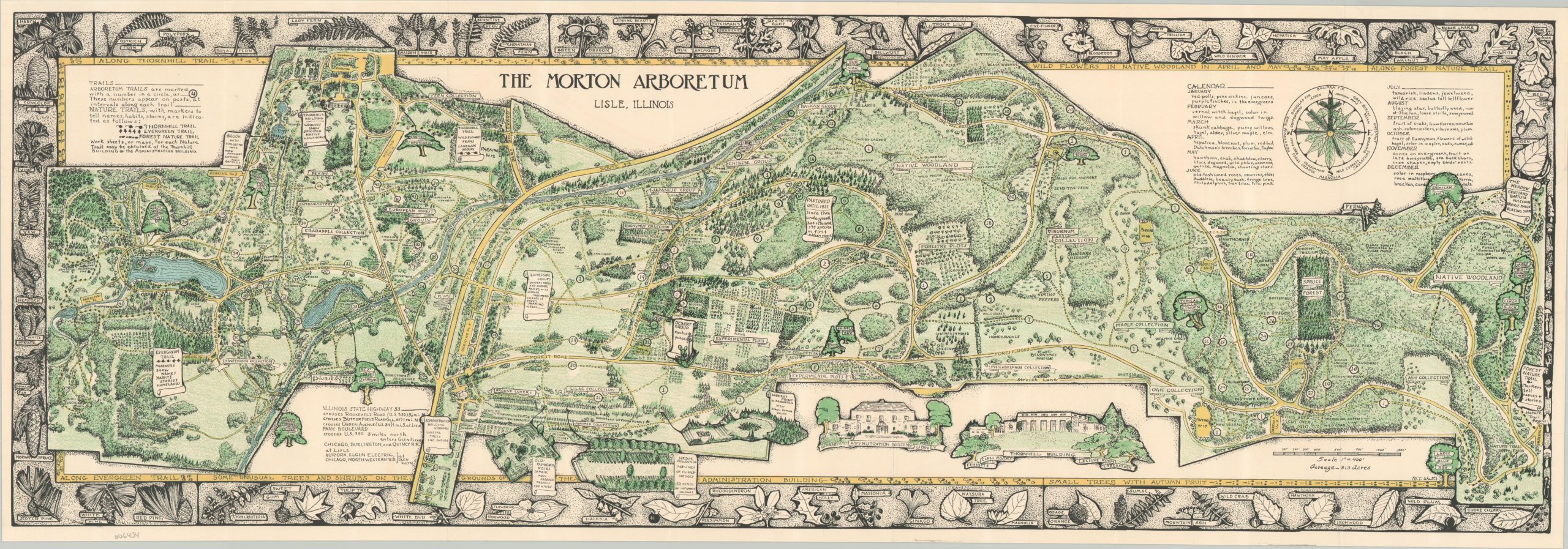
This wonderfully detailed map of the Morton Arboretum in Lisle, Illinois (about 25 miles west of Chicago) was originally designed by May Theilgaard Watts around 1947. It presents a delicate overview of the 813-acre plot, established in 1922 by the founder of Morton Salt, Joy Morton. Generalized areas, major landscape features, buildings, and transportation routes (including nature trails) are noted throughout the image. Dozens of flora species are available to arboretum visitors. According to a website dedicated to the author,
“This map of the Morton Arboretum, as it appeared in 1942, was given to visitors as they entered the Arboretum. It was a functional guide to the Arboretum and a remarkable educational tool in that every part is a “teachable moment” created by the drawings of May Watts. The border is made up of leaf silhouettes for the identification of trees and plants within the Morton Arboretum. A key of months instructs the reader on each month’s natural events. Within that key is a “compass rose” featuring significant leaves and evergreen branches. Special plant and tree collections are lovingly rendered with labels encouraging the discovery of those areas. There is always something new to see in the details of this beautiful drawing.”
May Theilgaard Watts (1893–1975) was an influential American naturalist, writer, and educator known for her contributions to ecological awareness and conservation. She spent much of her career at the Morton Arboretum in Illinois, where she worked from 1939 to 1961, primarily as a teacher and writer. At the Arboretum, she founded the renowned education program and developed nature study courses that emphasized the interconnectedness of natural systems. Watts is celebrated for her book Reading the Landscape of America, which taught readers how to interpret the history and ecology of the land. In 1963, she initiated the Prairie Path project, transforming an abandoned rail line into one of the first rail-to-trail conversions in the United States.
Sources: David Rumsey Map Collection; The Vision of May Theilgaard Watts;
Map Details
Publication Date: c. 1947
Author: May Theilgaard Watts
Sheet Width (in): 31.75
Sheet Height (in): 11
Condition: A
Condition Description: Color lithographed map printed on one side. Creased along six vertical folds, as issued. Near fine condition overall.
Out of stock