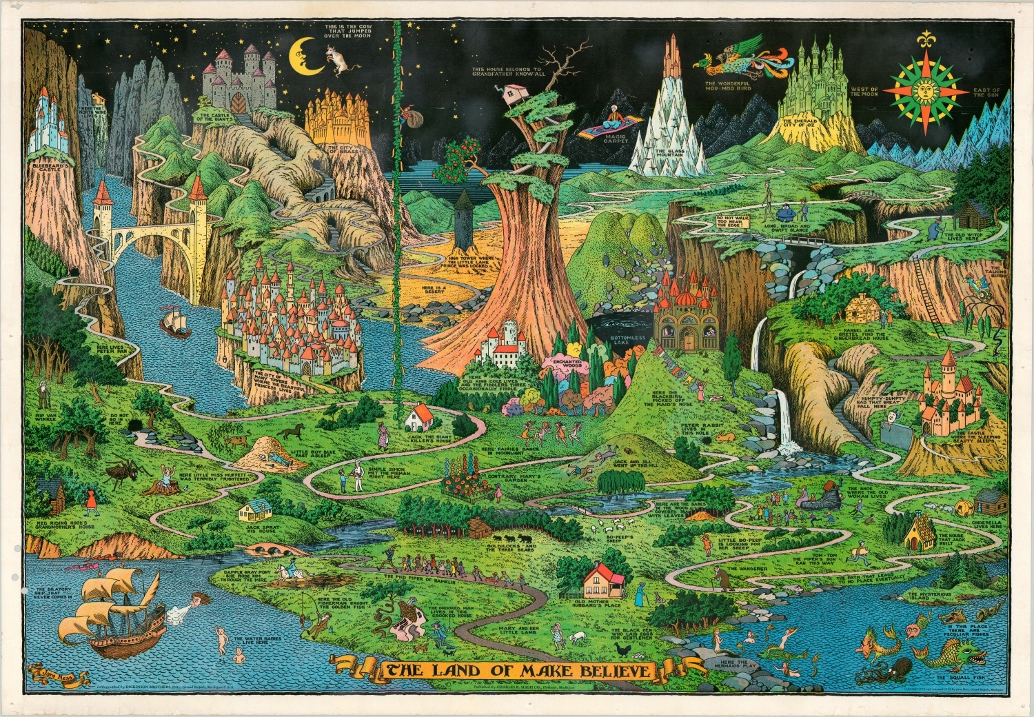
The Land of Make Believe
The third edition of one of the most iconic cultural maps ever produced in the United States.
Out of stock
Description
This map was originally drawn and published in 1930 by Jaro Hess of Grand Rapids, Michigan. Titling the image as “The Land of Make Believe,” Hess condensed a pantheon of characters and locations from pop culture, fairy tales, parables, and classical literature into one cartographic image.
This map is likely the only place, outside of one’s imagination, where Rip Van Winkle walks in the same forest as Red Riding Hood as the Emerald City of Oz rises in the background. There are over thirty individual references within the imaging, ranging from popular icons to items of obscurity, which compose a fantastic visual mythology.
“The Land of Make Believe is the only one of Hess’s works to achieve fame outside of Grand Rapids. The map was created in 1930 and was exhibited in the children’s section of Chicago’s 1933 Century of Progress World Exhibition.[i] There are disputes about who originally widely published the map, but Hess certainly distributed and sold copies and the map himself, and, regardless, the Land of Make Believe found its way into classrooms and children’s bedrooms across America.[ii]”
This particular example is the third edition, printed in 1958 under a renewed copyright owned by Hess himself. The image is identical to earlier issues, though one notable change is worth mentioning. The Wanderer in the lower right was originally labeled The Wandering Jew, referring to the myth of a Jewish man who was cursed to be immortal and walk the Earth forever after taunting Jesus en route way to the Crucifixion. The anti-Semitic tale has its origins in 13th century Europe, and though the stereotypical characteristics of a Jew remain, the name was slightly altered to be more politically correct.
This version of the map was published in Holland, Michigan by Charles R. Sligh, Co. Lithographed in Grand Rapids by Dickinson Brothers, Inc.
Map Details
Publication Date: 1958
Author: Jaro Hess
Sheet Width (in): 37.25
Sheet Height (in): 25.75
Condition: B+
Condition Description: Third edition, the 1958 issue published by Charles R. Sligh, Co. Three punch holes in the lower left corner unfortunately just enter the image, and the margins show spots of wear and discoloration ranging from mild to moderate. Pinholes in each corner and a bit of extraneous wrinkling from where the map was previously rolled.
Out of stock