Tartariae Sive Magni Chami Regni Typus
$1,500.00
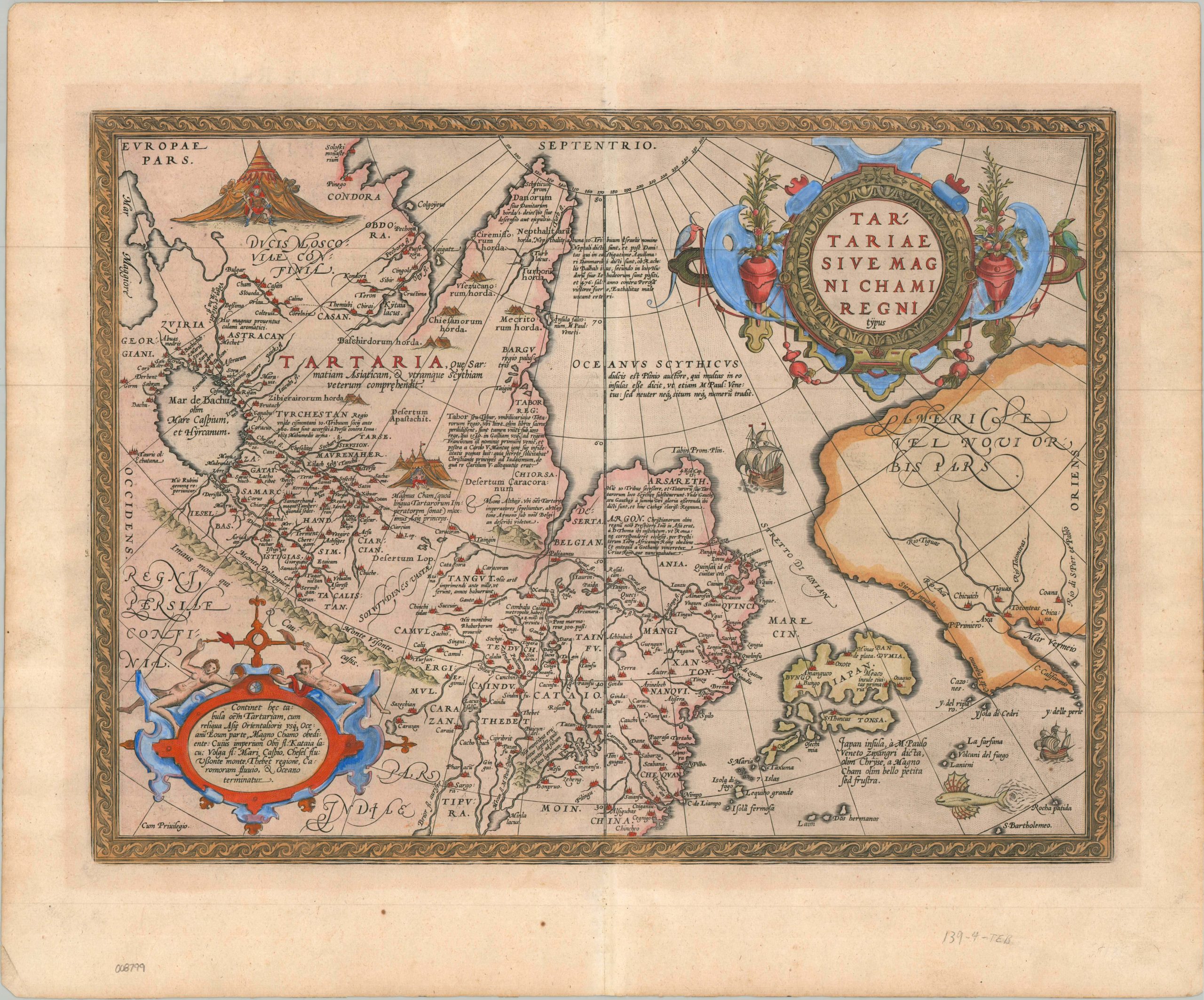
An important map of the North Pacific issued as part of the world’s first ‘modern’ atlas.
1 in stock
Description
This copperplate engraving is a definitive early map of Central and Northern Asia, published in Antwerp by Abraham Ortelius for his seminal 1595 Latin edition of the Theatrum Orbis Terrarum. Recognized as the first modern world atlas, the Theatrum standardized geographical presentation by compiling contemporary knowledge into a uniform format. This specific plate, titled Tartariae Sive Magni Chami Regni Typus, covers an immense geographic scope from the Ural Mountains and the Caspian Sea eastward to the Pacific Ocean, encompassing modern-day Russia, Mongolia, China, and Japan.
The geography depicted reflects a fascinating mix of Renaissance reconnaissance and persistent medieval concepts. Japan is shown with a distinctive, crescent-like configuration positioned close to the Asian mainland, while the Strait of Anian (the precursor to the Bering Strait) delineates the boundary between Asia and America, the northwest coast of which appears on the far right. The interior is densely populated with vignettes of nomadic tents, domestic animals, and historical annotations describing local customs and political boundaries.
To compile this map, Ortelius relied heavily on the landmark 1562 map of Russia by English merchant and diplomat Anthony Jenkinson, who had traveled extensively through the region on behalf of the Muscovy Company. Ortelius also incorporated details from the travel accounts of Marco Polo, visible in the heavy concentration of place names associated with the Grand Khan, and information derived from contemporary Portuguese charts for the coastal regions of East Asia.
The map includes several notable decorative features, including a prominent strapwork title cartouche in the upper right and a separate narrative cartouche in the lower left detailing the dominion of the Great Khan. Further annotations, scattered throughout, provide additional interesting commentary on local tribes and prominent landmarks. In the upper left, a distinctive vignette pictures a bearded leader emerging from a tent, weapon in hand. This possibly alludes to the recently deceased Ivan the Terrible (1530-1584), whose bloody reign was characterized by the militant expansion of Russian territory and interests.
Map Details
Publication Date: 1595
Author: Abraham Ortelius
Sheet Width (in): 21.75
Sheet Height (in): 18.25
Condition: A-
Condition Description: A magnificent old-color example with a crisp impression on sturdy laid paper. Some faint matte burn visible in the ample margins, which also show some faint wrinkling, and two small spots of foxing along the bottom. A bit of lightning along the vertical centerfold. Very good condition overall. Latin text on verso.
$1,500.00
1 in stock