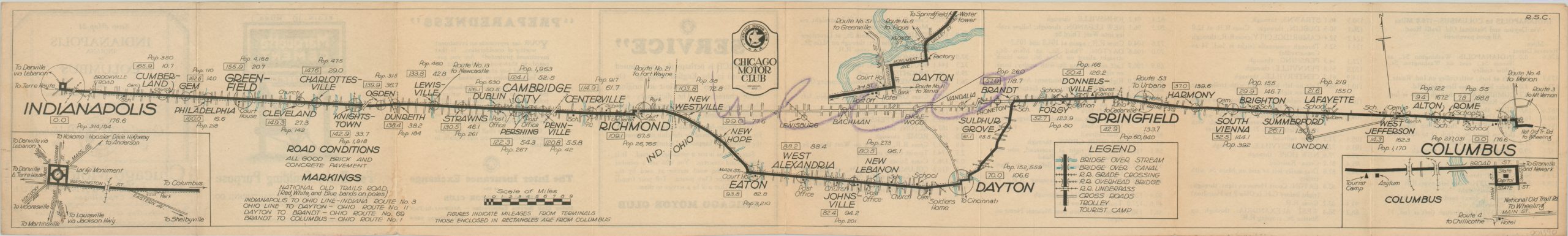
Strip Map 21 Indianapolis, Indiana to Columbus, Ohio
1923 strip map showing the automobile route between Indianapolis and Columbus.
Out of stock

Description
This folding strip map shows the 176.6 miles between Indianapolis, Indiana and Columbus, Ohio in tremendous detail. All towns, bridges, railroad crossings and crossroads encountered by the motorist following the highlighted route are indicated, as are the locations of churches, post offices, schools and other useful landmarks.
Inset maps of Indianapolis, Dayton, and Columbus are helpfully provided, adding small scale details to the major urban centers along the route, which primarily follows the National Old Trails Road. The distinctive red, white, and blue bands marking the highway are described within the image, as there was yet no uniform nationwide system for labeling and identifying roads.
The verso of the map features an itinerary of the trip with corresponding mileage, along with several advertisements for the Chicago Motor Club. This private organization, founded in 1906, grew rapidly to incorporate over 70,000 members by the mid-1920’s. The group, now a part of AAA, advocated for widespread automobile ownership, better road construction, favorable legislation, and other benefits for the intrepid motorist; such as handy maps that could be kept in the glove compartment!
Map Details
Publication Date: 1923
Author: Chicago Motor Club
Sheet Width (in): 31.75
Sheet Height (in): 4.75
Condition: B+
Condition Description: Issued folded into 8 panels. Faint wear along fold lines and one large area marked up with purple crayon. The front cover is toned, but overall the map remains in good to very good condition.
Out of stock