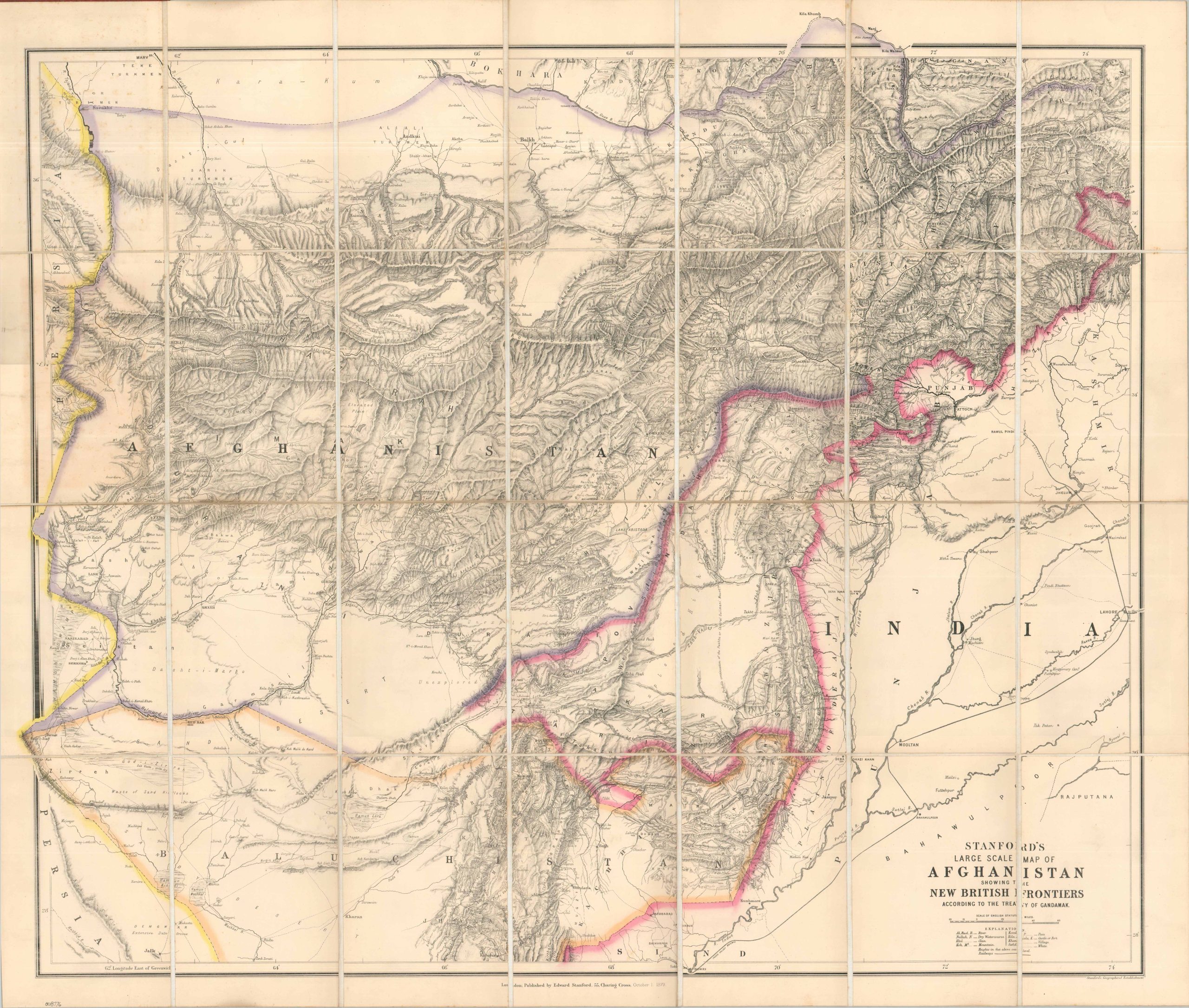
Stanford’s Large Scale Map of Afghanistan Showing the New British Frontiers According to the Treaty of Gandamak
A detailed snapshot of the mid-point of the Second Anglo-Afghan War.
Out of stock

Description
This marvelously detailed map covers a hotly contested border region between British India and Afghanistan that was an important part of the 19th-century playing board of the Great Game. In order to protect the Crown Jewel of the Empire, Britain sought to aggressively promote Afghanistan as a buffer state against an expanding Russia. The arrival of a Russian delegation in Kabul in 1878 set off a diplomatic crisis, prompting Britain to further restrict Afghan sovereignty. This escalated into a military conflict, the Second Anglo-Afghan War, which saw a British force of about 50,000 soldiers invade from northern India and the leased military base at Quetta (part of Balochistan). The Treaty of Gandamak was signed in May 1879 and resulted in Afghanistan ceding large swathes of its frontier territory to Britain, as well as handing over almost complete control of foreign affairs.
Dated October 1, 1879, the map was created just a few months after the ink was dry on the treaty. The carefully crafted image outlines the ceded lands in bright pink – the distinctive archetypal hue of the British Empire. The new region gave Britain control of several critical mountain passes from which it could better protect its Indian possessions. However, it’s extremely unlikely that Russia ever seriously intended to attack India. As depicted by the finely hachured topography and vast deserts, the region was one of the most rugged and remote on the planet. Rocky cliffs, steep mountain peaks, and parched plains made an invasion all but impossible, but the enduring threat made for excellent diplomatic leverage.
The map was issued in London in October, 1879 by the prolific publishing house of Edward Stanford. Though the Treaty of Gandamak was signed earlier in May, it took Stanford several months to obtain the precise details and incorporate them into new plates. During that period, the Second Anglo-Afghan War erupted again. On September 3, 1879, an uprising in Kabul led to the slaughter of the British representative and his troops, leading to a retaliatory force departing from the Kurrum Fort and recapturing the capital. Stanford would re-issue the map in July, 1880 to show the expedition’s route and affirm the Treaty of Gandamak.
Map Details
Publication Date: 1879
Author: Edward Stanford
Sheet Width (in): 37.75
Sheet Height (in): 32.30
Condition: A
Condition Description: Single-sided map dissected into 28 segments, mounted on linen, and bound to original red leather boards (quite sturdy). A bit of light marginal soiling and faint spotting, but overall in near fine condition.
Out of stock