
Rand McNally Standard Map of the Borough of the Bronx
$750.00
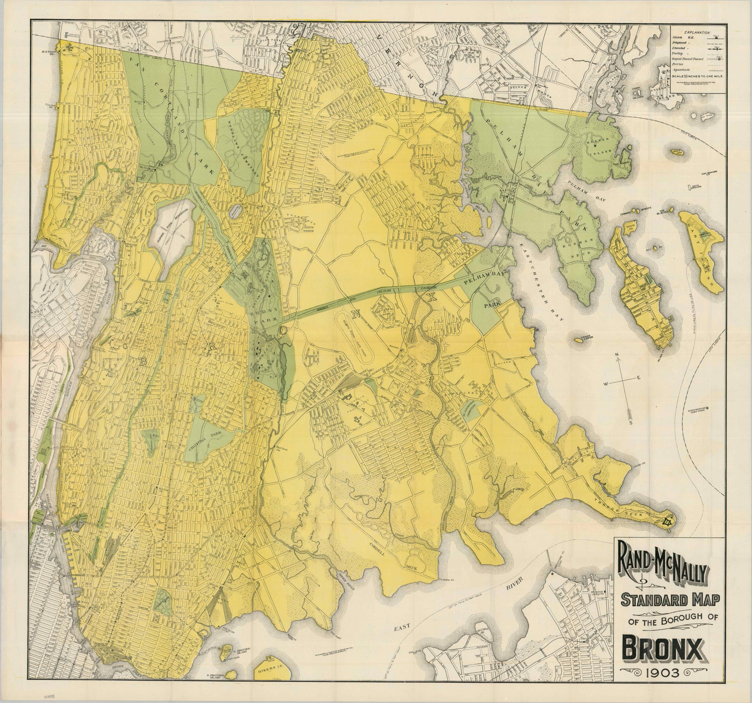
Scarce pocket map of the Bronx published just a few years after complete incorporation.
1 in stock
Description
This marvelously detailed map of the Bronx was published in 1903 by the Chicago-based firm of Rand McNally & Company. Just five years earlier, the ‘Greater New York’ consolidation annexed several eastern towns like Westchester, Williamsbridge, and Wakefield, fully absorbing them into the newly defined borough of the Bronx. With the promise of rapid transit, ample greenspace, and modern apartments, the borough’s population exploded after the turn of the century.
The map presents a carefully outlined street plan, noting the borough’s limits in bright yellow. Numerous parks and connecting boulevards (including the Bronx and Pelham Parkway) are highlighted in green, reflecting significant attention to outdoor leisure and recreation. The Botanical Gardens and Zoological Park, world-class institutions, are two of the Bronx’s most recent cultural additions. The growing transportation network is also emphasized, with steam, elevated, proposed, and trolley lines (plus rapid transit tunnels and ferries) noted according to the legend in the upper right.
These vital avenues of transit fueled intense real estate speculation, with developers buying up old farms and plotting new towns as fast as surveyors could lay them. Often, the necessary infrastructure could not keep up. A lack of sewers and paved roads meant that mud and refuse accumulated in the streets. Expansive lowlands are noted along the Bronx River – this area was essentially an open-air dump. Aqueducts are also noted in the key. Along with the Jerome Park Reservoir (then under construction), miles of pipes, and pump stations, this complex water distribution system struggled to provide adequate hydration for the masses.
In spite of its drawbacks, the Bronx offered immense allure to the crowded tenement buildings of Manhattan. Many of the apartments had indoor plumbing and steam heating. New industrial employment, healthcare facilities, recreational opportunities, and cultural/religious institutions were being constructed regularly. Of particular interest are the golf links in Van Cortlandt Park (the first public course in America), the Morris Park Race Track, New York University (now Bronx Community College), and the Mott Haven Iron Works.
Other contemporary locations reveal a grittier side to the Bronx and the fringes of the metropolis. North Brother Island was home to Riverside Hospital (labeled Small Pox Hospital), a notorious quarantine facility for highly contagious diseases that were rampant at the turn of the century. Nearby Rikers Island was the municipal dump; home to thousands of tons of coal ash, horse manure, and household garbage that burned uncontrollably due to volatile methane emissions. Occupying a massive footprint just north of Unionport, the Catholic Protectory was the largest reformatory and orphanage in the entire U.S. at the time. Hart Island features a Potter’s Field, where the unclaimed dead are laid to rest in nameless rows.
Map Details
Publication Date: 1903
Author: Rand McNally & Company
Sheet Width (in): 31.50
Sheet Height (in): 29.75
Condition: A
Condition Description: Color printed map folded on a single sided sheet, folded and affixed to textured paper wraps with faded gilt lettering. Shap creasing along folds and a bit of light marginal wear, but overall in near fine condition.
$750.00
1 in stock