Persia and Afghanistan
Original price was: $1,250.00.$1,000.00Current price is: $1,000.00.
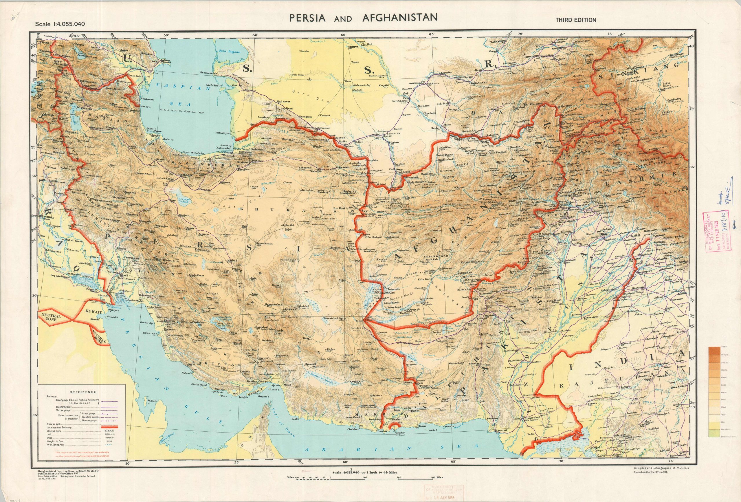
British mapping of the crossroads of Asia during the mid-20th century.
1 in stock
Description
This detailed map of Persia (Iran), Afghanistan, Pakistan, and the southern Soviet Union was originally created by the British War Office’s Geographical Section, General Staff in 1912. This is the third edition, with revised international boundaries and railways as of early 1950. Rubberstamps from the Directorate of Military Survey Map Library indicate a received date of 1952, with deaccessioning the following year (likely a new sheet was created following the Iranian coup).
The vast, mountainous region, the primary theater of the Great Game, had long played a critical role in British politics as a key buffer zone protecting the Raj. The 1907 Anglo-Russian Convention briefly established respective spheres of influence, but the outbreak of World War I and the Persian campaign of 1914 brought Russia, Great Britain, and the Ottoman Empire to blows. During the interwar period, the U.K. again reclaimed regional authority (albeit using different means) via the Third Anglo-Afghan War and the Anglo-Persian Agreement (both 1919). The Partition of India (1947) resulted in the creation of Pakistan, though the newly independent nation would inherit border disputes with adjacent Afghanistan and continue to function as a containment to Soviet influence.
These tremendous political changes (and others) are vaguely hinted at within this topographic map. While international boundaries are clearly and apparently authoritatively defined in bright red, the Kashmir question remains open-ended and several disputes remain unsolved. The enclave of Gwadar is one example of territory that would change hands (to Pakistan) in the coming years. The Neutral Zones around Kuwait (known as the Divided Zone) were of critical importance, as oil would be discovered in significant quantities in 1953.
The ‘black gold’ was among Britain’s primary geopolitical concerns at the time of publication, though the map makes little mention of the stuff. The region’s harsh and rugged terrain is highlighted through colored contoured relief. The railway network is also emphasized, broken down by gauge, and those lines completed or under construction/proposed. While aviation was gradually becoming dominant militarily, railways remained the primary mechanism for freight and passenger transport. An interesting variety of geographic features is labeled, including sources of water, mountain peaks (generally with corresponding height, in feet), and passes (including Khyber, Dorah, Bolan, etc.)
Map Details
Publication Date: 1950
Author: Geographical Section, General Staff
Sheet Width (in): 34
Sheet Height (in): 22.5
Condition: B+
Condition Description: Color lithographed map on a single-sided sheet with moderate wear in the margins; pinholes in the corners, several closed tears (mostly repaired, though one affects the height scale in the lower right), creasing, and two rubberstamps. Retains original vibrant printed color and remains in very good condition overall.
Original price was: $1,250.00.$1,000.00Current price is: $1,000.00.
1 in stock