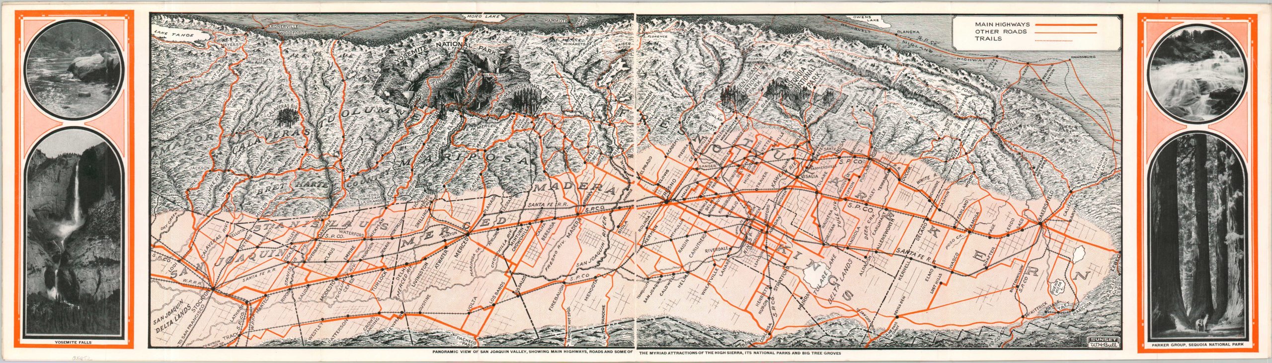
Panoramic View of San Joaquin Valley, Showing Main Highways, Roads, and Some of the Myriad Attractions of the High Sierra
$110.00
Come and visit “The Garden of the Sun”!
1 in stock


Description
“The great valley stretches from south to north for a distance of more than 200 miles. Along the eastern side towers the loftiest range of mountains in America. In this great system there are literally thousands of spots – many of them comparatively unknown – distinctly worthwhile to those who are wise enough to steal a few days each year from the routine of life.” – Text, back cover.
This charming brochure was published as a cooperative effort by numerous local Chambers of Commerce in towns across the San Joaquin Valley. A centerfold image illustrated by talented landscape artist William Bull presents a strict delineation between the arable (and easily traversable) valley and rugged surrounding mountains. Less of a distinction is made between the ‘Main Highways’ and Other Roads, though the dotted lines of the regional hiking trails are easy to distinguish. Yosemite, Sequoia, General Grant, Mariposa, and Calaveras are all proudly outlined and labeled. Elsewhere, numerous blocks of descriptive text showcase local points of interest and communities in the valley. Photographs of major attractions include General Sherman (tree), Vernal Falls in Yosemite, Mt. Keith, numerous fishing spots and auto roads, and a panorama of the summit of Mt. Whitney.
Map Details
Publication Date: c. 1928
Author: William Howell Bull
Sheet Width (in): 26
Sheet Height (in): 9
Condition: A-
Condition Description: Centerfold topographic map in a 16 pp. brochure, folded into eighths with stapled binding. A few small closed tears along the outer edges. Creasing and light wear along old folds and on the illustrated covers, but overall in very good condition.
$110.00
1 in stock