Orbis Typus Universalis Iuxta Hydrographorum Traditionem Exactissime Depicta 1522
“A much sought after” map that “reflects the ambiguities of its age” [Shirley]
Out of stock
Description
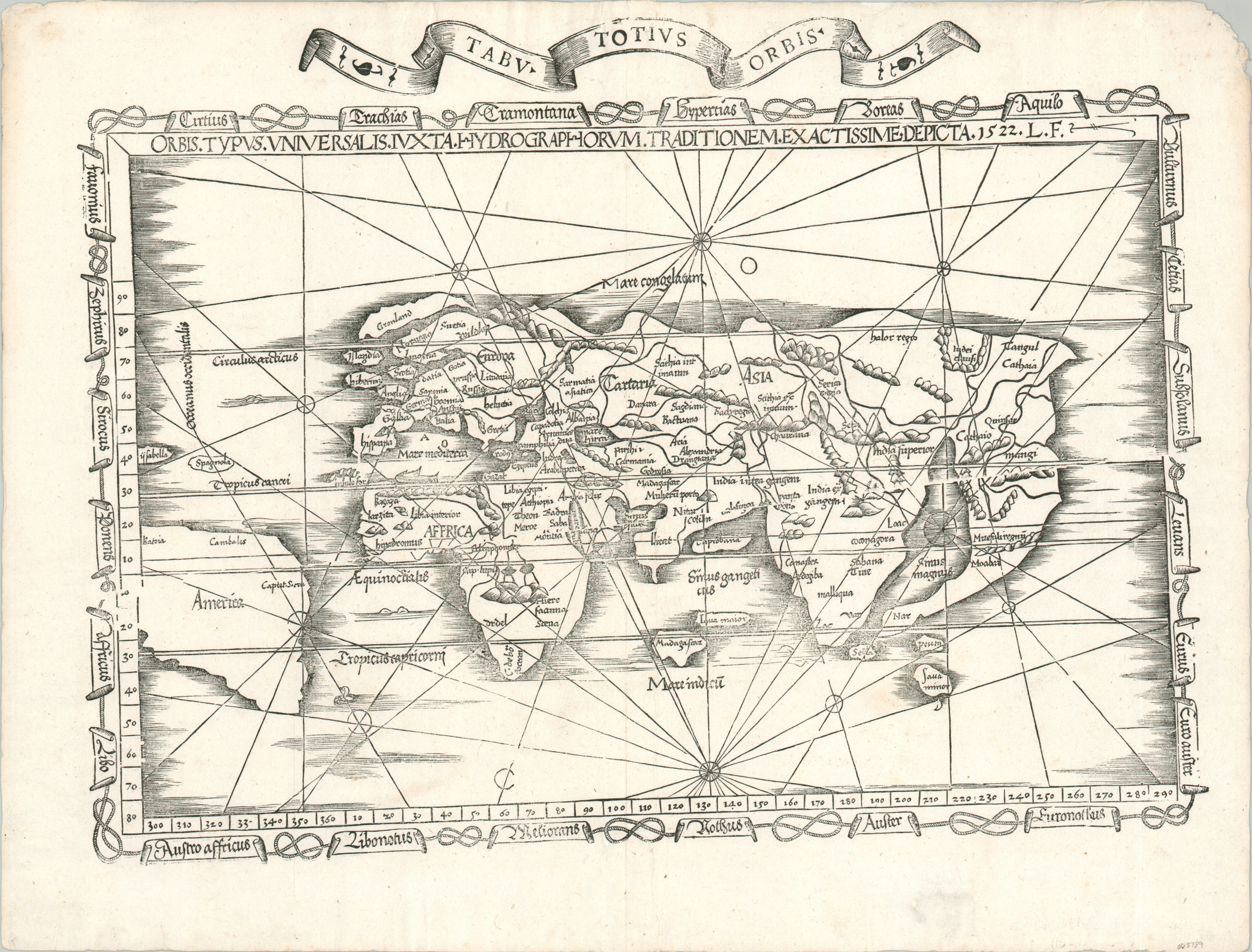
This stunning woodblock map of the world was published in Lyons, France in 1535. It’s one of the earliest maps obtainable to collectors today to name ‘America’, as can be seen prominently in the surprisingly (though coincidentally) accurate outline of the southern continent.
Columbus had first encountered the New World just over four decades prior to publication, and his other discoveries on the islands of Isabella and Hispaniola are also labeled. Three other toponyms are shown – ‘Batoia,’ ‘Cambales,’ and ‘Caput Sacre’ – but North America is omitted entirely. The rest of the image presents a fascinating mix of ancient and contemporary geographic sources, with no lack of spurious details. As described by Rodney Shirley, “A framework of medieval thinking is having to be re-cast in order to accept the as yet unrealized extent of the newly conquered lands.”
Scotland and England are shown as distinct islands, while Greenland and Scandinavia are heavily distorted and Iceland is missing entirely. Africa exhibits largely Ptolemaic features, with the Mountains of the Moon prominently rising in the south of the continent, though the Portuguese circumnavigation is clearly evident. Madagascar is placed closed to Java and the Indian Subcontinent is divided into two peninsulas with the legendary Taprobana (probably Sri Lanka) in the middle. Rhumb lines radiate from several points and a decorative border identifying the various directional winds surrounds the image.
The map was first designed by Laurent Fries and published in 1522, just months before the return of Magellan’s Victoria from its first circumnavigation of the globe (albeit without its captain). Fries was a 16th-century physician, geographer, and astrologer who was well educated in philosophy and medicine and born around 1490 near Colmar. He published several early pharmaceutical tracts before settling in Strasbourg around 1519. It was here that he began editing the cartographic works of Martin Waldseemuller, the first mapmaker to name America in his 1507 wall map of the world that exists in only one known copy.
Fries essentially created reduced versions of Waldseemuller’s maps for an updated edition of Ptolemy’s Geographia, including this ‘new’ map of the world. It was first published as part of the Geographia in Strasbourg in 1522, with subsequent editions in 1525 (Strasbourg), 1535 (Lyons) and 1541 (Lyons). This particular example originates from the 1535 Ptolemy, as indicated by the Tabu. Totius Orbis banner across the top and the crack in the woodblock visible in the center-right. The 1535 edition is notable for being edited by Michael Servetus, who was burned at the stake for blasphemy in 1553. The pyre upon which he was executed was comprised partially of his edited books and published materials, making this work one of exceptional rarity.
References; Shirley 48, Karrow 28/51.
Map Details
Publication Date: 1535
Author: Laurent Fries
Sheet Width (in): 20.75
Sheet Height (in): 15.60
Condition: A-
Condition Description: Soft creasing and wear confined to the outer margins, including some paper loss in the upper right and a spot of professional fill in the lower right. Vertical centerfold is hardly noticeable and the impression is crisp and clean. Very good overall.
Out of stock