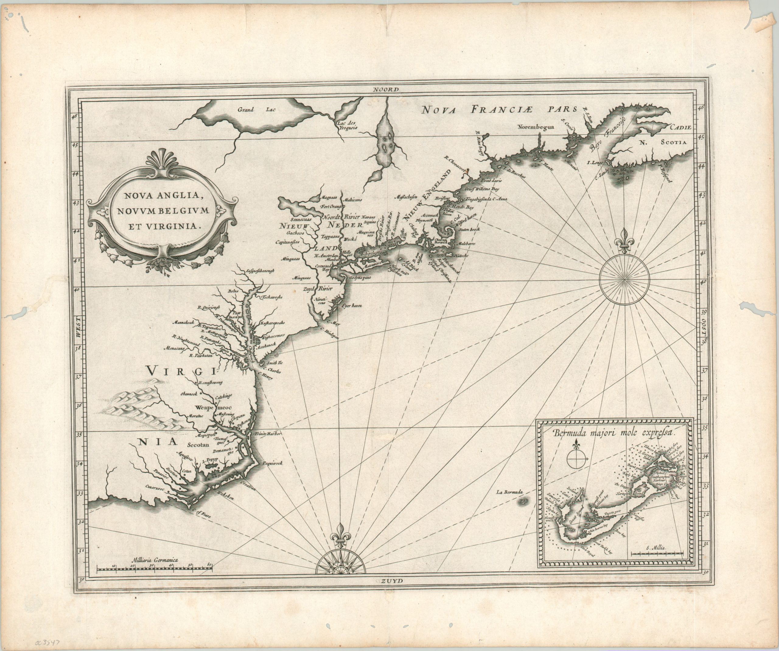
Nova Anglia, Novum Belgium, et Virginia
The first printed map to name Manhattan and New York [New Amsterdam].
Out of stock
Description
This foundational map of the Atlantic coastline of North America covers a broad, though surprisingly accurately depicted, territory between the English colony of Virginia (modern-day North Carolina) and the coast of Nova Scotia, then part of New France. It embodies a critical period in the development of colonial ambitions in the New World, as the Dutch, English, and French all vied for territory, trading partners, military allies, and religious converts.
It presents a litany of ‘firsts’ for a printed map, including the first to name an insular Manhattan (Manbattes), the first to name New York (N. Amsterdam, founded just four years before publication), the first to name Massachusetts (Massachusetts), and the first to identify any of the Great Lakes (Grand Lac). An inset map of Bermuda is one of the earliest to show the island in any detail, and the inclusion of New Belgium in the title is also one of the first instances to appear on a map. According to Schwarz & Ehrenberg, “The appearance of Novum Belgium on this and other maps of the period refers to the fact that the Dutch West India Company was underwritten in part by Protestant Belgians.”
The map was published in Leiden in 1630 as part of Johannes de Laet’s Nieuwe Wereldt often Beschrijvinghe van West-Indien (Description of the West Indies). The work was originally issued in 1625 and contained ten maps – this is from the slightly updated version that contained fourteen maps and an additional 100 pages of text, reflecting the increased interest of the Dutch in the New World.
Described by Philip Burden as “arguably the finest description of the Americas published during the seventeenth century,” the maps in de Laet’s work were based directly off the cartography of Hessel Gerritsz, considered by some to be the foremost mapmaker of the Dutch Golden Age of Cartography. Gerritsz was the exclusive cartographer for the Dutch East India Company and had access to some of the most up-to-date information available. His maps are generally only available in manuscript form and those published by de Laet are some of the few available to collectors today.
Johannes de Laet was no slouch, either, and he used meticulous research and contemporary sources when compiling his geographic data. As a director of the newly formed Dutch West India Company, the latest information from private correspondence, manuscripts, and other company secrets would have also been made available when compiling the maps.
Sources: Shirley (BL Atlases) G.LAET-1b, Burden #231, Schwarz & Ehrenberg pl. 57 & pg. 105,
Map Details
Publication Date: 1630
Author: Johannes de Laet
Sheet Width (in): 16.50
Sheet Height (in): 13.60
Condition: B+
Condition Description: Several spots of worming remain visible in the margins, with a few in the interior of the image professionally repaired and restored, where applicable. One small pair of offsetting holes can be seen immediately below 'Noord' in the upper border, while a second area requiring minor paper fill is visible near the lower third of the page (along the centerfold).
Out of stock