Milk R. to the Crossing of the Columbia R. From Explorations & Surveys Made under the Direction of the Hon. Jefferson Davis, Secretary of War.
$195.00
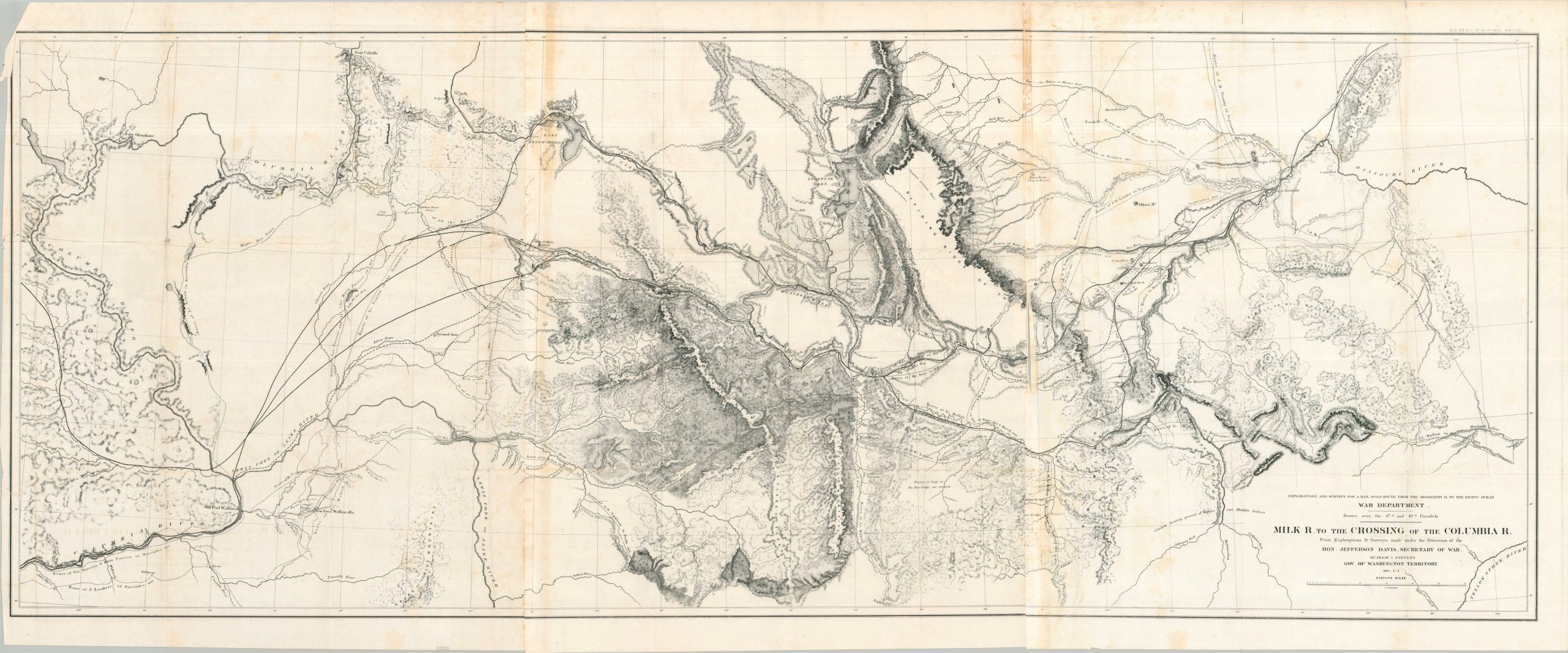
The northern section of the Pacific Railroad Survey.
1 in stock
Description
This fascinating mid-19th-century map delineates the broad territory along the 47th parallel, stretching from Fort Benton (Montana) on the Missouri River to Fort Walla Walla (Washington) on the Columbia. It presents the definitive results of the Northern Pacific Railroad Survey, led by Isaac Stevens, Governor of the Washington Territory, between 1853 and 1855. Stevens’ party famously included Captain George B. McClellan, the future Union General-in-Chief, marking this as a foundational document of both Western expansion and Civil War-era biography.
The expedition was one of five transcontinental surveys commissioned by Secretary of War Jefferson Davis to determine the most viable rail route to the Pacific. These federally sponsored explorations effectively “opened” the American West in the wake of the California Gold Rush, providing the first systematic scientific records of the region’s geology, botany, and ethnography. The map meticulously plots the various routes undertaken by Stevens’ command, with dated itineraries highlighting the seasonal progression of the survey across the rugged interior.
The topography is rendered through sophisticated hachuring, providing a dramatic visual overview of the Bitterroot Mountains, Lewis & Clark’s Pass, and the Continental Divide. Beyond the physical geography, the plate serves as a detailed census of the mid-century frontier, labeling scattered Jesuit missions, military outposts, Indian agencies, and fur trading posts. Published in Washington, D.C., in 1860 by the Government Printing Office, this map was a key component of the landmark Reports of Explorations and Surveys presented to the 36th Congress.
Sources: Wheat (TMW) #867; Stanford University; Eastern Washington University
Map Details
Publication Date: 1860
Author: Isaac Stevens
Sheet Width (in): 60.60
Sheet Height (in): 23.30
Condition: B
Condition Description: Black & white map on three sheets, joined along seams that have toned (presumably from the adhesive). The upper left corner has been separated and reattached with archival tape. Scattered light foxing and creasing along original folds. Better than fair, but not quite good condition overall.
$195.00
1 in stock