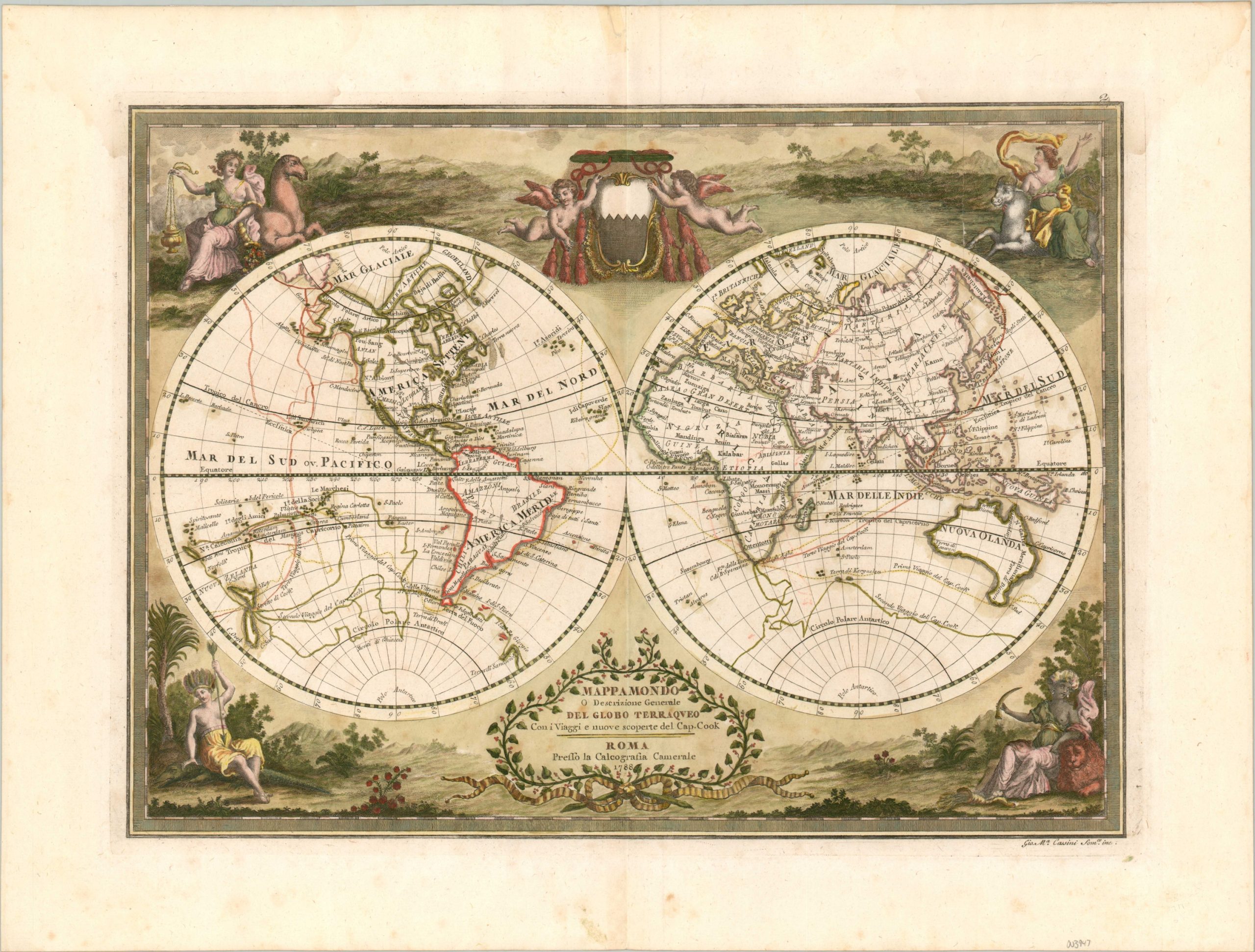
Mappamondo o descrizione genarale del globo terraqueo
Magnificient and rare double hemisphere map chronicling Cook’s voyages around the globe.
Out of stock
Description
This beautiful map of the world presents a late 18th-century cartographic celebration of the voyages of Captain James Cook. Between 1768 and his death in 1779, Cook led three incredible expeditions into the Pacific Ocean on behalf of the British Admiralty. He and his crew were the first Europeans to discover Hawaii, land on the eastern shore of Australia, circumnavigate New Zealand, and make contact with numerous peoples of the Pacific Islands.
The resulting scientific discoveries in the fields of geography, navigation, botany, and anthropology were some of the most significant of the century. Cook’s legacy and esteem were held in such high regard that, even during the Revolutionary War, Benjamin Franklin implored American sailors to “treat the said Captain Cook and his people with all civility and kindness … as common friends to mankind” should they encounter him on the high seas.
The image incorporates Cook’s discoveries less than ten years later and shows the routes of his three voyages in yellow, green, and orange. Australia is depicted in a largely recognizable form, though Tasmania remains a peninsula, and several Pacific island groups including New Zealand, the South Sandwich Islands, and Hawaii are identified with some degree of accuracy. There is a fascinating portrayal of the Northwest Passage attributed to Vitus Bering (B. di Beering) and nearby is one of the first printed examples on a map to use the name Alaska (Algka).
Surrounding the map are four decorative scenes containing allegorical figures representing Africa, Asia, Europe, and the Americas; each accompanied by an animal and symbols from their respective lands. Two putti hold aloft a (possibly incomplete) crest at the top of the sheet, while a decorative cartouche near the bottom contains the title.
The map was created by Giovanni Maria Cassini in 1788, but it wouldn’t be published publicly until 1791. It was issued in Rome by Calcografia Camerale as part of Nuovo Atlante Geografico Universale..
Map Details
Publication Date: 1788
Author: Giovanni Maria Cassini
Sheet Width (in): 22.4
Sheet Height (in): 16.9
Condition: B+
Condition Description: Two faint damp stains are visible in the upper corners, extending down into the image about 2 inches. Light scattered spotting visible in a few other places, including the top of the centerfold and in the title cartouche. Minor offsetting from the red ink visible in Africa. The color oxidization has resulted in minor paper brittleness, with some separation in the upper right corner reinforced on the verso with archival materials. Good to very good condition overall, with attractive old color and a crisp impression.
Out of stock

