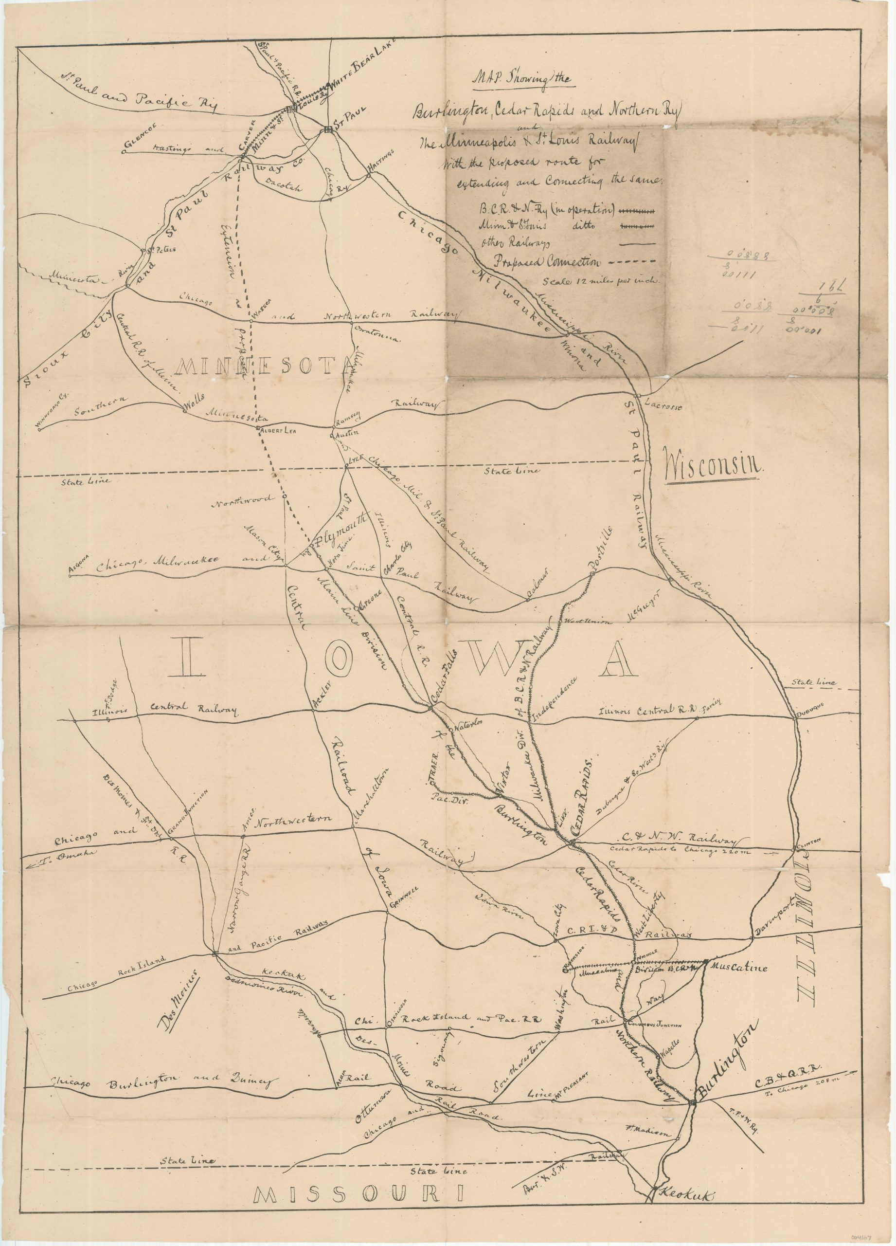
Map Showing the Burlington, Cedar Rapids, and Northern Railway and the Minneapolis and St. Louis Railway
$775.00
Unrecorded map of the Burlington, Cedar Rapids and Northern Railway.
1 in stock
Description
This remarkable railroad map shows the routes of the Burlington, Cedar Rapids and Northern Railway and the Minneapolis and St. Louis Railway across the states of Minnesota, Iowa, Wisconsin, and Illinois (though trackage is confined to the first two). Apparently drawn by an unknown hand on lithographic stone and printed, the map was issued within a year of the former company’s organization in 1876.
The proposed route connecting the two lines between Plymouth, Iowa and Albert Lea, Minnesota is the primary indicator of the map’s age, confirmed by the operational dates of the myriad of other companies labeled across the image. According to an essay on the BCR&N by Frank Donovan;
“The late 1870s saw new construction, although it was not until the next decade that vigorous expansion ensued. The most important item on the earlier agenda was the opening of the famous Albert Lea Route in 1877.
By building a 5-mile extension from Plymouth Junction to Manly Junction, the BCR&N hooked up with the Iowa Central Railway. From Manly, trackage rights were had over the latter road to Northwood; and from Northwood the BCR&N built its own track to the Minnesota border, where it connected with the Minneapolis & St. Louis Railroad for Albert Lea and the Twin Cities.
Here was the beginning of a new through line from the Twin Cities, via Albert Lea, Cedar Rapids and Burlington, to St. Louis. South of Burlington the train ran over the present Chicago, Burlington & Quincy Railroad to the Missouri metropolis.”
As far as I can tell, the map is unrecorded. I’ve been unable to find another example of the map in OCLC or other online repositories. Not in Stover’s Historical Atlas of the American Railroads or Modelski, though the LoC has an example of the 1868 Burlington, Cedar Rapids and Minnesota Railway that is mentioned in the latter.
Sources: John Marving Railroad Bridge Photography; Iowa Railroads: The Essays of Frank P. Donovan, Jr; Library of Congress: 98688606
Map Details
Publication Date: c. 1876
Author: Anonymous
Sheet Width (in): 20.5
Sheet Height (in): 28.5
Condition: B-
Condition Description: Heavily worn along old fold lines. Two panels (formerly on the exterior of the folded map) in the upper right show moderate discoloration, damp staining, and manuscript notes in pencil. Separation and creasing along fold lines present in several places, with the worst tears repaired on the verso with archival tape. Despite the defects, the rare map retains a complete image that resides somewhere between fair and good. Printed on thin paper that's blank on the verso.
$775.00
1 in stock