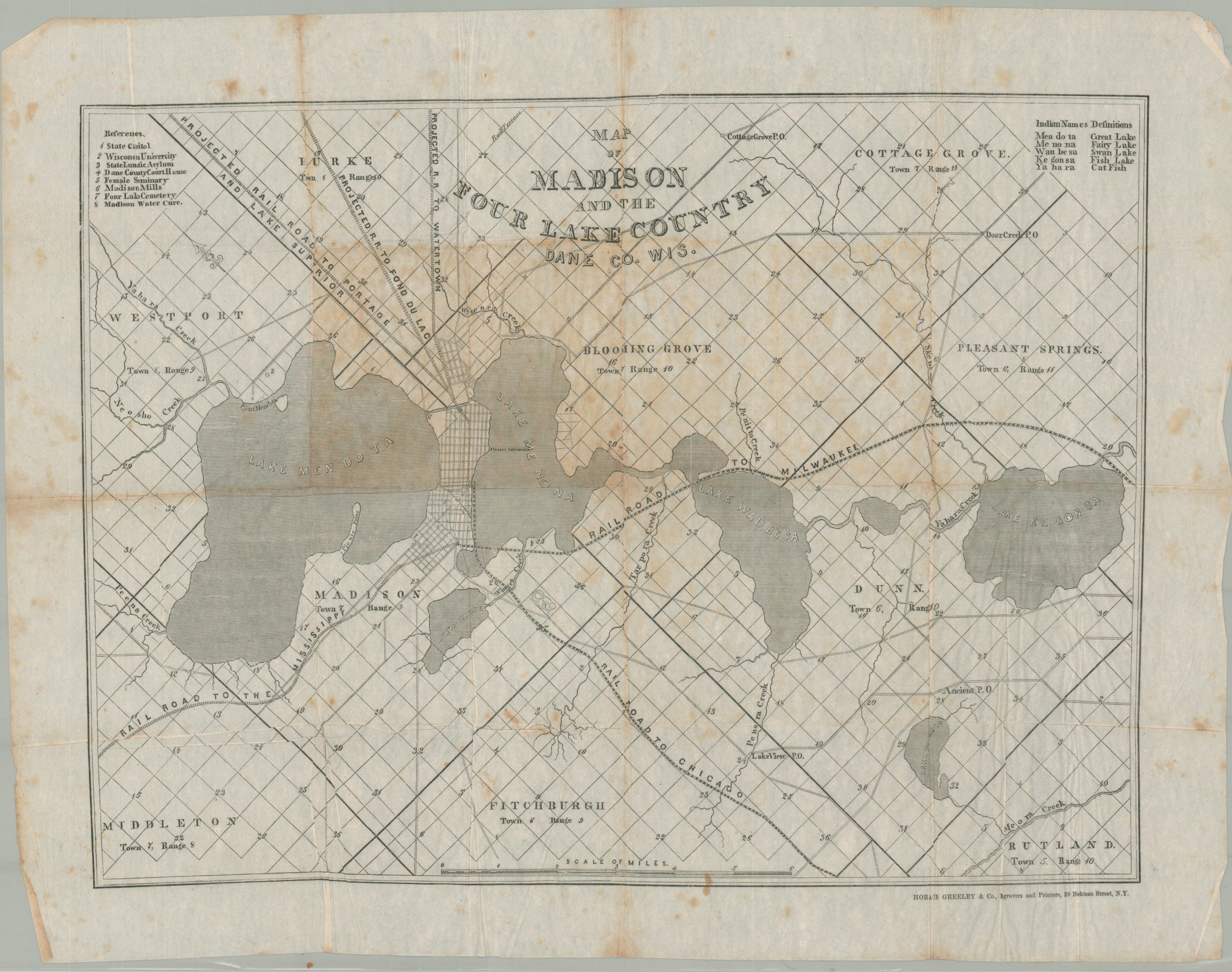
Map of Madison and the Four Lake Country Dane Co. Wis.
The first printed map to officially name Madison’s Four Lakes.
Out of stock
Description
This early map of Madison, Wisconsin, and the surrounding region was published in New York by Horace Greeley & Co. in 1854. It is the first printed map to ‘definitively’ name the area’s iconic Four Lakes – Mendota, Monona, Waubesa, and Kegonsa. Though various names had been given on earlier maps, the bodies of water were often referred to numerically (i.e. First, Second, Third, Fourth). However, these were not appealing enough for Wisconsin’s 2nd governor, Leonard James Farwell, who was diligently encouraging migration to the state. According to an article in the Wisconsin Magazine of History;
“Governor Farwell was preparing for the real estate boom of 1855, of which this map was to be an important instrument. He could not have such prosaic names as First Lake and the rest, on his map; some more euphonious and attractive names had to be found and substituted.”
He worked with the Secretary of the State Historical Society, Robert Edward Draper, and an early Wisconsin historian, Frank Hudson, to help determine more ‘appropriate’ names for the Four Lakes. Again, from the article; “Though all are of Indian languages, none was given by the Indians, nor do the languages of their origin belong in the region of the Four Lakes.”
The image shows a selective overview of the region about two years before Madison was officially incorporated as a city. This is little to distinguish the projected and constructed railroads, giving an almost false impression of the area’s transportation network. Roads are also shown, extending to rural post offices and the surrounding surveyed townships. Eight different locations of interest are numbered and identified in the upper left, including Wisconsin University, the State Lunatic Asylum, and a Female Seminary.
The map was published in at least three different editions, though this is likely the first. All are scarce on the market.
Source: JSTOR (Wisconsin Magazine of History); Alternate Example at the Wisconsin Historical Society; Alternate Example at Swann Auction Galleries
Map Details
Publication Date: 1854
Author: Horace Greeley & Co.
Sheet Width (in): 25.25
Sheet Height (in): 19.4
Condition: B
Condition Description: Issued on extremely thin tissue paper that has heavy creasing along old fold lines. Moderate discoloration and toning visible in the middle of the sheet and a few small spots in the lower center, near the distance scale. About good condition overall, but considering the fragility of the paper, it's in remarkable shape.
Out of stock

