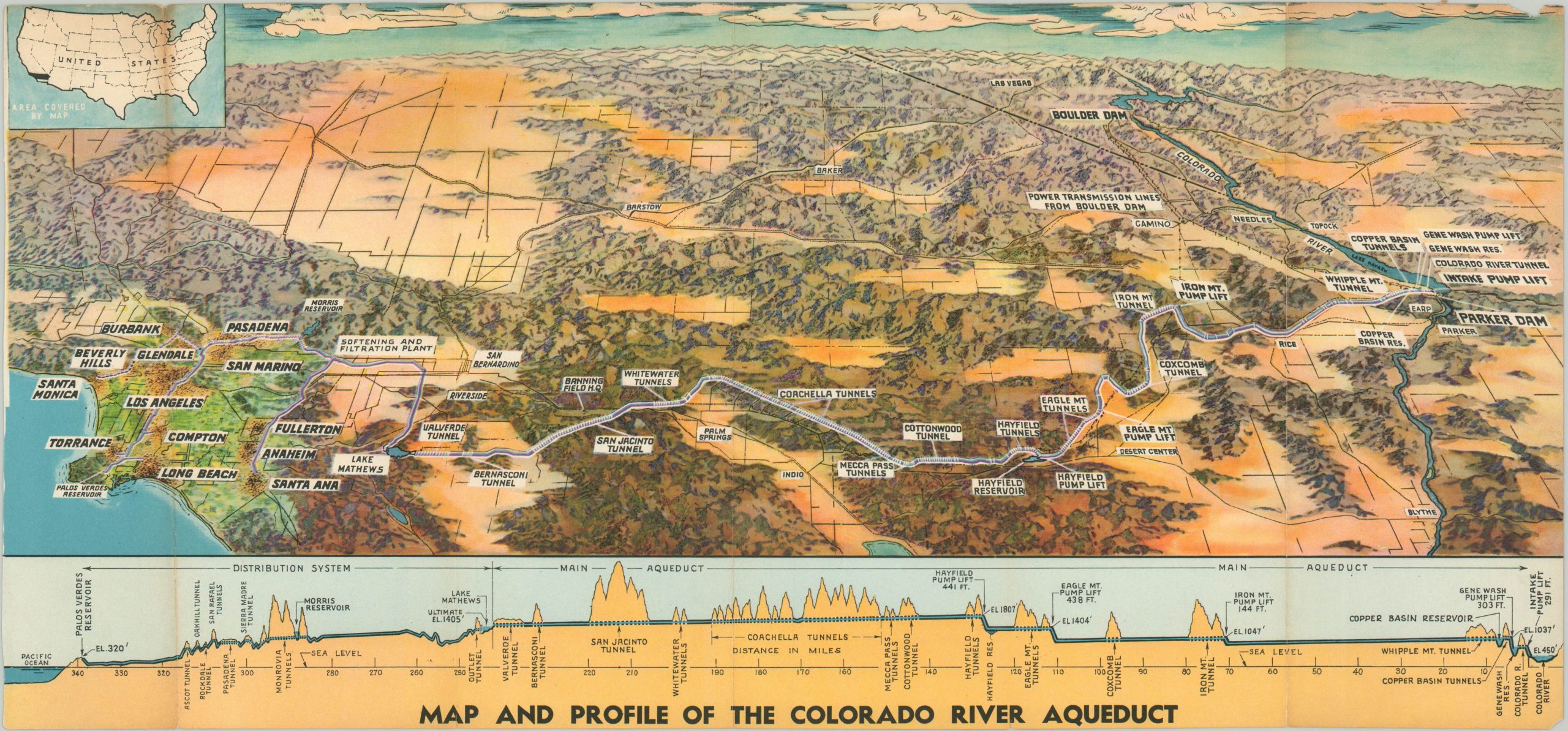
Map and Profile of the Colorado River Aqueduct
$225.00
Dramatic overview of one of the “Seven Wonders of American Engineering.”
1 in stock
Description
This stunning panoramic view captures one of the most monumental construction efforts that took place in the United States during the 20th century. The Colorado River Aqueduct runs over 240 miles from Lake Havasu to Southern California, providing one of the region’s primary drinking sources. [From an article written by Glen Creason, map curator of the Los Angeles Public Library]
Historical discussions surrounding the importance of a water supply in L.A. focus mostly on the LA River’s Zanja Madre (“Mother Ditch”) and the 240 mile-long Los Angeles Aqueduct, which first flowed in 1913 and quite literally opened the city up to unlimited growth. The latter, a great engineering feat spearheaded by William Mulholland, was essential in allowing Los Angeles to provide that most valuable commodity inexpensively to her citizens in a time when it had become a dire necessity. But we should not forget that Mulholland (not Hollis Mulwray) was a true visionary—he saw into the future, one in which much more of the controversially purloined liquid (well, according to the farmers of the Owens Valley) would be needed.
From the beginning, Mulholland and chief engineer Frank Weymouth had an eye on the abundant waters of the Colorado River despite the ruddy silt that gave the river its name. In 1923 they began a four-year-long series of surveys to find the most feasible route for carrying water from Arizona to Los Angeles. As was the case with the Los Angeles Aqueduct (completed in 1913), every inch of route was battled over in courts (and in the papers). In 1928, the Metropolitan Water District was formed for the express purpose of building the Colorado River Aqueduct and transporting the water to the city. March 12 of that same year, the St. Francis Dam (also designed and built by Mulholland) tragically collapsed, taking both 600 lives and the brilliant engineer’s reputation in one terrible night.
Nevertheless, the Colorado River Aqueduct plan continued, with voters approving a $220 million bond issue for a 10-year project set to begin in 1933. The construction of the Colorado River Aqueduct was no easy task; it involved a risky path west across the Mojave and Colorado Deserts, traveling 242 miles east of the Santa Ana mountains at Lake Matthews and eventually into the metropolitan area of L.A. The aqueduct was capable of carrying one billion gallons of water from Arizona to California in 24 hours. Along the way there were two reservoirs, five pumping stations, 61 miles of canals, 92 miles of tunnels, and 84 miles of buried conduit.
The aqueduct was finished in a miraculous eight years despite many trials and tribulations (including seepage in the San Jacinto tunnel, seen here at mid-point on the map). Los Angeles received the first “soft and filtered water” from the CRA on June 20, 1941, but Pasadena’s found the taste of Colorado River water to be less than agreeable.
In the end, the Colorado River Aqueduct supplied water to 14 cities, 12 municipal water districts, and some 130 municipalities. William Mulholland died about halfway through construction in 1935, but he did see the start of one last idea that proved to be crucial to Los Angeles’s survival. In 1955, the Colorado River Aqueduct was recognized by the American Society of Civil Engineers as one of the seven Engineering Wonders of American Engineering.
Map Details
Publication Date: 1938
Author: Metropolitan Water District of Southern California
Sheet Width (in): 17.50
Sheet Height (in): 9.00
Condition: B
Condition Description: Small chip and loss of image in the upper right and lower left corner. Creasing and faint discoloration along five vertical fold lines.
$225.00
1 in stock

