
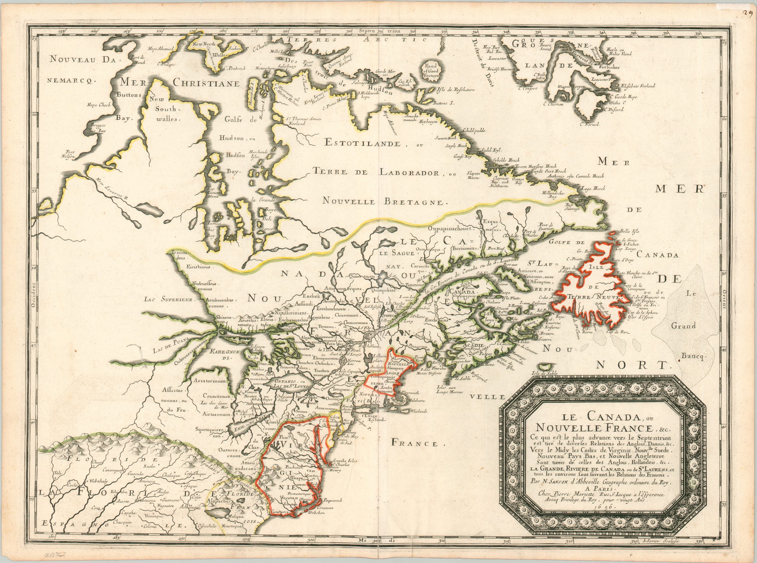
Le Canada, ou Nouvelle France, &c.
A seminal map in the cartography of the Great Lakes.
Out of stock
Description
This foundational map of North America covers a broad region from Florida in the south to Greenland in the North Atlantic. The image presents the distribution of Native American groups, colonial settlements, and territorial claims by various European powers including the English, Spanish, and French (from the latter’s perspective). Topography is shown pictorially, with the ‘Apalatcy Montes’ prominently labeled in the lower left. Also of interest is the open waterway in Button’s Bay – the hopes for a viable Northwest Passage would persist on maps into the 18th century.
The map was created by Nicholas Sanson and published in Paris in 1656. The image is based largely on Sanson’s map of North America from 1650 but incorporated the latest available information. As Royal Geographer to King Louis XIV, Sanson had access to the manuscript writings and personal correspondence of French voyageurs and Jesuit scholars.
As a result, this map is the first printed example to show the Great Lakes in a largely recognizable form, though their names would undergo some further changes. Lac de Puans [Lake of Stenches] represents Green Bay, while the ‘ou do Chat’ [of the cat] added to Lake Erie refers to the fearsome local tribe known sometimes as the People of the Panther (the Erie Indians). The outline of the Great Lakes would provide the foundation for the cartography of the region for the next half-century, until it was superseded by maps by Guillaume DeLisle.
Sanson and Delisle were two of the best-known French cartographers who elevated the art during their long and illustrious careers. As summarized by Conrad Heidenrich and Edward Dahl;
“The mapping of New France during the seventeenth century, then, stands in sharp contrast to the more impressionistic mapping done during the previous century. It was a period that witnessed a striking increase in the technical competence of the men who made the original observations that were incorporated on the maps, a period that was marked by a reluctance to incorporate myths and wishful thinking. By and large, the maps of this century were honest attempts to unravel the geography of New France as gathered by direct observation and reliable native accounts.”
Sources: Schwarz and Ehrenberg plate 62; Kershaw Plate 81; Goss 33; Burden 318; The French Mapping of North America in the 17th century by Edward Dahl and Conrad Heidenreich, Map Collector #13, Dec. 1980; Michigan State University Library;
Map Details
Publication Date: 1656
Author: Nicholas Sanson
Sheet Width (in): 22.60
Sheet Height (in): 16.60
Condition: A-
Condition Description: Light spotting and minor offsetting visible in the lower quarter of the sheet and minor edge wear and soiling consistent with age. One or two tiny spots within the image and a bit of darkening around the neatline from the plate strike. Very good overall with original outline color.
Out of stock