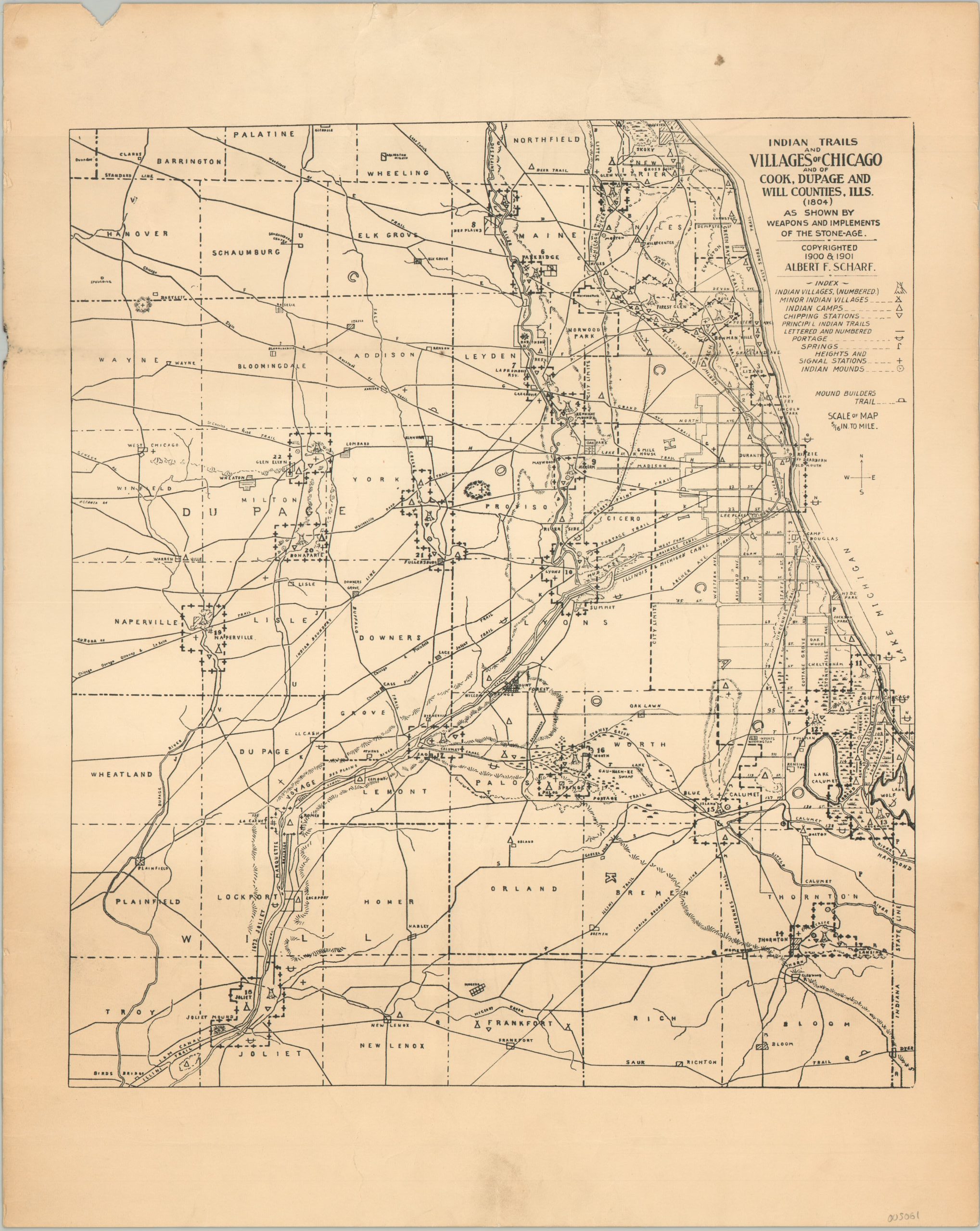
Indian Trails and Villages of Chicago and of Cook, DuPage, and Will Counties, Ills.
A comprehensive study of early Native American sites around the Chicago area.
Out of stock
Description
This detailed map of northeastern Illinois reflects some of the most extensive research performed on local indigenous people in the late 19th century. It presents a wealth of information on the early Native American inhabitants of the region. Described by Sue Devick;
“A well known map of over twenty Native American villages around pre-Settlement Chicago was created by Albert F. Scharf and Karl Dig in the 1890’s, and it is entitled “Indian Trails and Villages of Chicago and of Cook, DuPage and Will Counties, Ills. (1804).” The Scharf Map, as it is commonly known, is useful for establishing the locations of trails, villages, camps, ceremonial mounds, signal stations, chipping stations, and other important elements of indigenous life in and around Chicago. An index explains the meaning of symbols: larger Indian villages are marked by a tepee; minor villages by a smaller tepee; camps as triangles; chipping stations (where tools were made) as upside down triangles; trails as lines; signal stations as plus signs; and Indian mounds by a dotted circle surrounding a point. Mounds were ceremonial in nature, and tribal chiefs were known to have been buried in some of these structures. Other less common features such as portage routes and fresh water springs are also represented in the map’s index, as well.
The cartographers’ research manuscripts are at the Chicago History Museum, and they reveal significant attention to detail. These documents include descriptive locations of indigenous villages according to Township and Section numbers as well as to geographical features and roads. Artifacts such as a sentry’s battle ax recovered at the La Frambois Reservation (Village No. 7) and other physical evidence are included, which lend integrity to the map’s historical information; also listed are the names of individuals who provided direct knowledge of relevant events or situations. Background narrative is found in the manuscripts, as well, such as Potawatomi Chief Alexander Robinson’s statement that Chief Waubonsee had a “voice like a lion,” adding dimension.”
Source. Fuller Historic Society
Map Details
Publication Date: c. 1902
Author: Albert F. Scharf
Sheet Width (in): 13.5
Sheet Height (in): 17
Condition: B
Condition Description: A chip in the upper left margin and several spots of wrinkling and soiling visible in the margins, concentrated in the center at the top and bottom of the page. The bottom 6" or so is faintly, but evenly toned. About good condition overall.
Out of stock