Geographical, Statistical, and Historical Map of the West Indies
Interesting overview of the colonial situation in the West Indies from first quarter of the 19th century.
Out of stock
Description
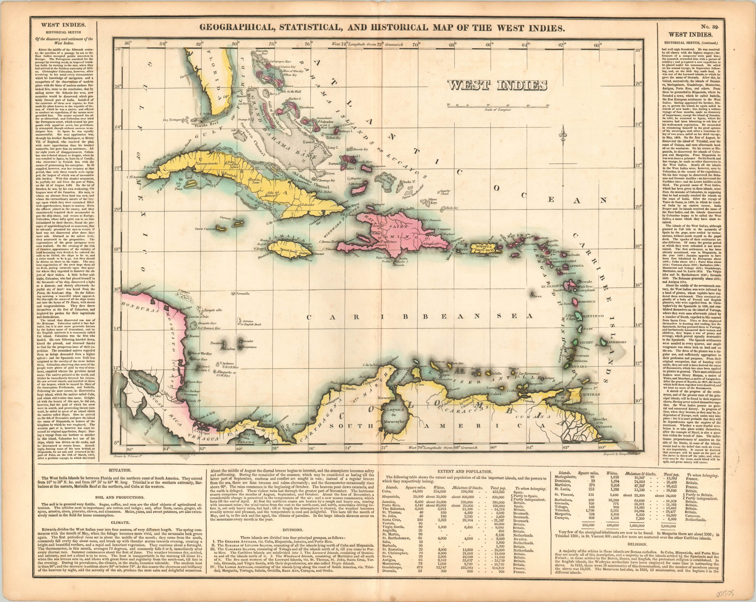
Having obtained their name to distinguish the islands from the East Indies of Southeast Asia, the West Indies were first visited by Columbus during his historic voyage of 1492. Post-Columbian contact brought waves of European invaders, diseases, and the scourge of African slavery – decimating local populations, cultures, and economies that had existed for hundreds of years. Native inhabitants were wiped out, and their local way of life was supplanted by the plantation system. Those indigenous people that remained were quickly brought under the control of European colonizing powers, where they would remain for nearly 400 years.
This map shows the waning period of colonial occupation in the Americas, with the majority of North and South America having attained their intendance in the late 18th and early 19th centuries. The Caribbean was different, however, and each island is shown colored in the distinctive shade of its respective European “owner” – yellow for Spanish, green for the Dutch, and red for the British. Interior details are scarce, with place names confined largely to the coasts, but numerous navigational hazards and keys are depicted.
Surrounding the image are numerous blocks of text outlining the climate, geography, history and political organization of the West Indies; including a table of the islands with demographics and “to whom belonging.” The map was drawn by Fielding Lucas, Jr. and engraved by Young & Delleker. It was included as sheet number 39 in the 1822 (first) edition of Carey & Lea’s Complete Historical, Chronological, and Geographical American Atlas.
This important American publication was issued in six separate editions and three different languages between 1822 and 1827. It was heavily influenced by an earlier European atlas by Emmanuel Las Cases (published under the pseudonym A. Lesage.), which inspired the format of a base map surrounded by blocks of informative text and tables of statistics.
Henry Carey, a political economist and the son of prominent publisher Matthew Carey, and his brother-in-law Isaac Lea incorporated this novel theme into their atlas, which focused entirely on the countries of the Western Hemisphere. It was issued at a time of tremendous political change in both North and South America, and the detailed maps accompanied by extensive text provide a unique, often insightful, perspective on the problems and possibilities of the Americas in the first quarter of the 19th century.
Wheat, C. I. (2004). Mapping the Transmississippi West: 1540-1861. Mansfield Centre (CT): Martino Publishing. #348
Egli, L. G., & Phillips, P. L. (1974). A list of geographical atlases in the Library of Congress. Washington: Library of Congress. #1373
Map Details
Publication Date: 1822
Author: Carey & Lea
Sheet Width (in): 22.25
Sheet Height (in): 17.60
Condition: A-
Condition Description: Features bright original hand color on a clean sheet, save for a bit of toning in the margins and faint offsetting within the image. Minor wear along the vertical centerfold. Very good or better condition overall.
Out of stock