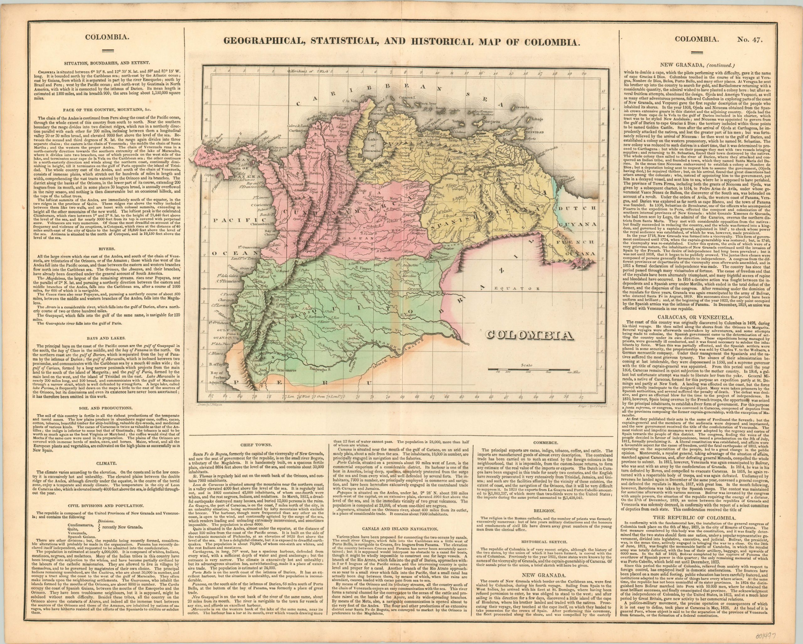
Geographical, Statistical, and Historical Map of Colombia
Original price was: $125.00.$85.00Current price is: $85.00.
An outdated map of the short lived state of Gran Colombia.
1 in stock
Description
The former Republic of Colombia (known today as Gran Colombia to distinguish it from the modern country of the same name) achieved its independence from Spain by a loose coalition of resistance movements united under the banner of the Liberator, Simon Bolivar. Galvanizing local opposition against the Spanish and leveraging support from across South America and overseas, Bolivar was able to overthrow royalist forces and proclaim a federal republic with himself at its head.
It was originally formed into three departments around the capital cities of Bogota, Quito, and Caracas – delineated by hand color within the image. But by the time of the map’s publication, the state had further splintered into several more administrative divisions, reflecting the internal tensions simmering under the unified facade. Despite the outdated political information, the map presents interesting information on local industries (mining in particular), geographic features (Chimborazo and other peaks are labeled) and pictorial topography.
Surrounding the image are numerous paragraphs of text providing additional details on the history, climate, geography, and politics of the country. The aforementioned political stresses are also alluded to within the text – “a politico-military movement, the precise operation or consequences of which it is not easy to define, took place at Caraccas in May, 1826. At the head of it is general Paez, whose object is said to be the separation of the Province of Venezuela from Granada, or the formation of a federal constitution.” Paez would eventually claim success in 1830, when he proclaimed Venezuelan Independence. Ecuador and New Granada (the forerunner to modern Colombia) were not long to follow, and by 1831 Gran Colombia was no more.
The map was drawn by J. Finlayson and engraved by J. Yeager. It was issued as sheet number 47 in the 1827 edition of Carey & Lea’s Complete Historical, Chronological, and Geographical American Atlas.
This important American publication was issued in six separate editions and three different languages between 1822 and 1827. It was heavily influenced by an earlier European atlas by Emmanuel Las Cases (published under the pseudonym A. Lesage.), which inspired the format of a base map surrounded by blocks of informative text and tables of statistics.
Henry Carey, a political economist and the son of prominent publisher Matthew Carey, and his brother-in-law Isaac Lea incorporated this novel theme into their atlas, which focused entirely on the countries of the Western Hemisphere. It was issued at a time of tremendous political change in both North and South America, and the detailed maps accompanied by extensive text provide a unique, often insightful, perspective on the problems and possibilities of the Americas in the first quarter of the 19th century.
Wheat, C. I. (2004). Mapping the Transmississippi West: 1540-1861. Mansfield Centre (CT): Martino Publishing. #348
Egli, L. G., & Phillips, P. L. (1974). A list of geographical atlases in the Library of Congress. Washington: Library of Congress. #1373
Map Details
Publication Date: 1827
Author: Carey & Lea
Sheet Width (in): 21.90
Sheet Height (in): 17.50
Condition: A-
Condition Description: Faint discoloration and some separation along the vertical centerfold, the latter repaired on the verso with archival tape. A bit of soiling in the upper margin, and some darkening to the sheet from the impression of the plate. Very good or better condition overall.
Original price was: $125.00.$85.00Current price is: $85.00.
1 in stock

