[Four Campaign Maps of the 79th Infantry Division]
Original price was: $975.00.$795.00Current price is: $795.00.
A striking group of four maps chronicling the WWII experience of the 79th Infantry Division across Europe.
1 in stock
Description
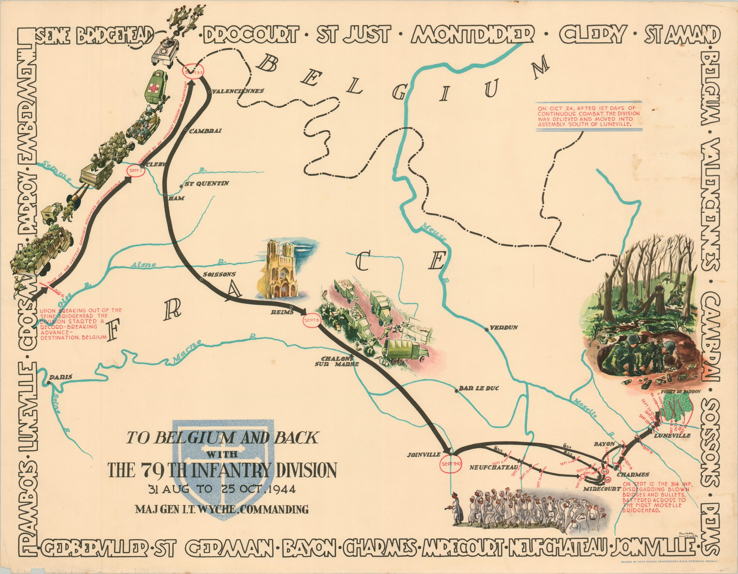
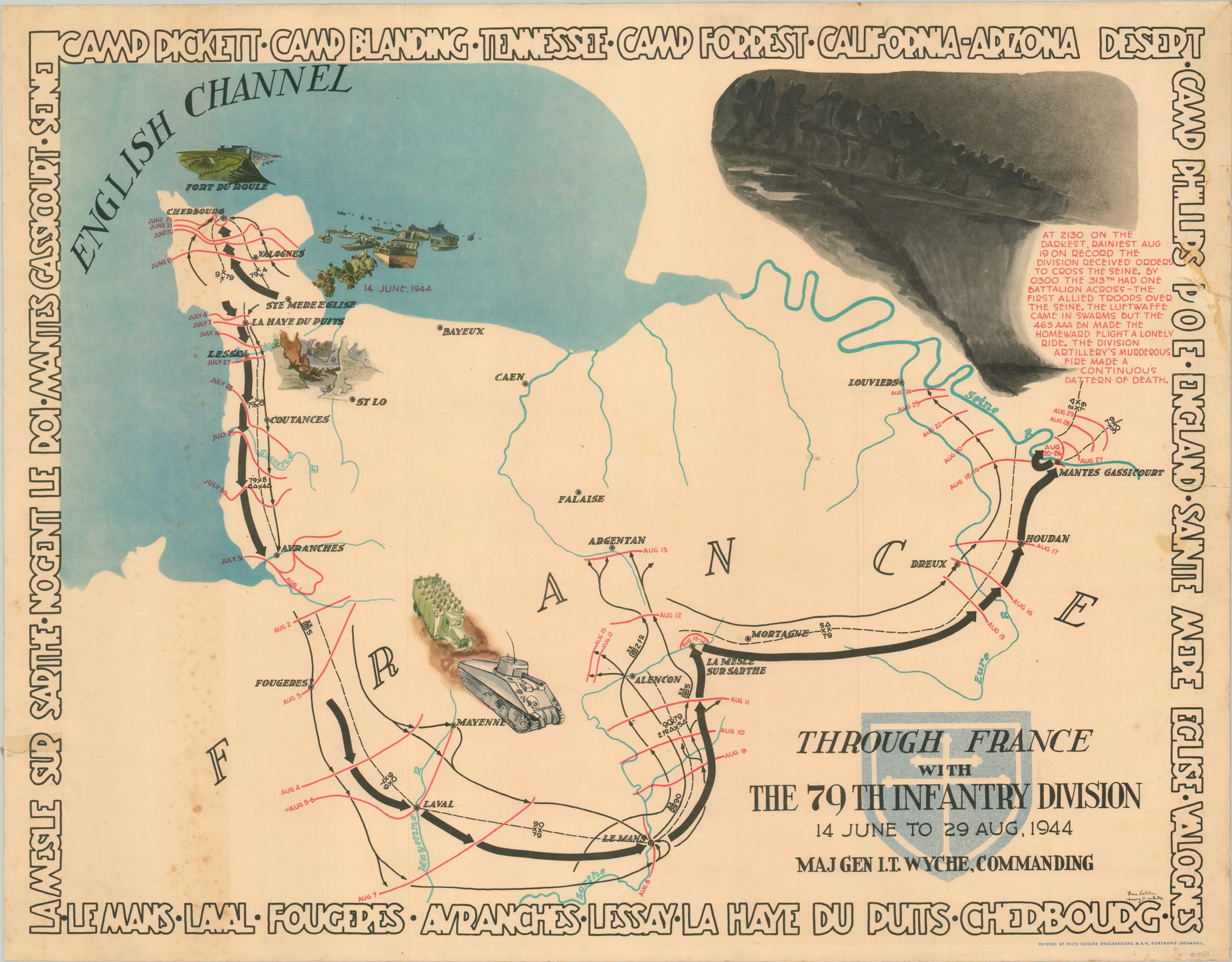
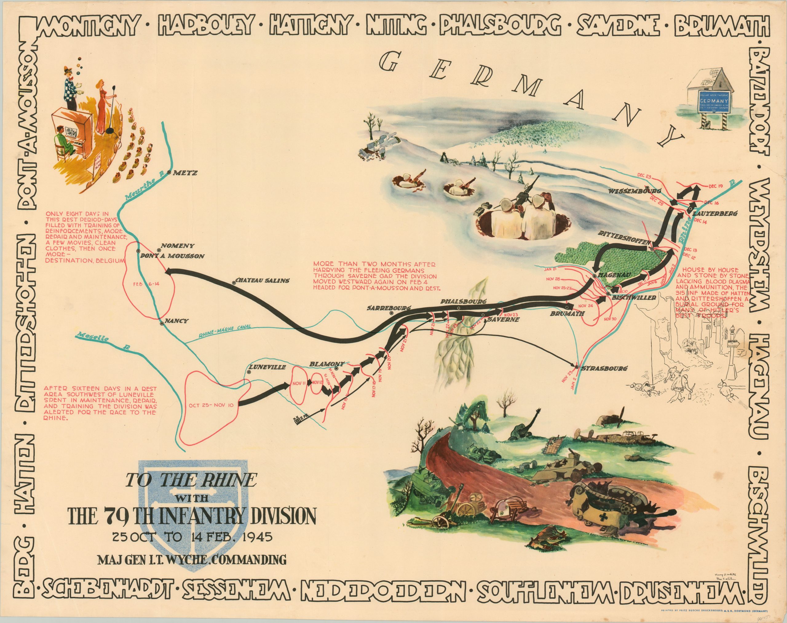
This eye-catching set of four maps provides a vivid and comprehensive overview of the path taken across Europe by the 79th Infantry Division during World War II. Drawn by two members of the division, Steve Kaliher and Harry White, the text and imagery presented on each sheet is significantly more realistic than the caricatures drawn on similar campaign chronicles produced by other units.
Each headquarters location is identified and dated in red, and are accompanied by black lines of various styles and thickness indicating the advance of the division or various component units. Surrounding each map is a border naming the locations within the image visited by the 79th, nicknamed the “Cross of Lorraine” for it’s heroic actions in France during WWII. The icon is also seen on the divisional emblem, which appears on each sheet under the title block.
Through France with the 79th Infantry Division 14 June to 29 Aug, 1944. The first sheet in the group covers the unit’s rapid advance from the beaches of Normandy (landed on D+8, June 14th) to crossing the Seine River in late August. A large illustration with accompanying text in the upper right depicts the dreary crossing and credits the 463 AAA battalion for their effective coverage against the Luftwaffe – “The division artillery’s murderous fire made a continuous pattern of death.”
To Belgium and Back with the 79th Infantry Division 31 Aug to 25 Oct 1944. The second sheet covers the approximately two month period after crossing the Seine, when the 79th briefly entered Belgium and resumed its advance eastward across France. The early days of the march are noted as “one of the fastest opposed advances of comparable distance by an infantry division in wartime” while the illustrations highlight the carnage of battle, the chaos of the supply system, and the thousands of German prisoners taken by the unit.
To the Rhine with the 79th Infantry Division 25 Oct to 14 Feb 1945. The third sheet in the series begins with a two week respite east of the Moselle River, before resuming the rapid pace into Germany. Progress is shown as constant until December, when the Battle of the Bulge threw the Allied offensive into disarray. The viciousness of the fighting is explained in a note on the right side of page. Contrasting illustrations highlight the extremes of the war – watching a show in France, then onto frozen foxholes and burned out tanks in Germany.
Over the Rhine with the 79th Infantry Division 17 Feb to 9 May 1945. The final sheet in the series shows the last push into Nazi Territory, across the Rhine and Roer Rivers into the Ruhr Industrial Valley. Bridge building efforts are illustrated in the upper left, while a second vignette in the center right depicts an American soldier surrounding by gracious European citizens, including Germans themselves. Accompanying text outlines the general feelings – “Each man was filled with pride in his combat record and confidence in the future.”
Map Details
Publication Date: 1945
Author: Steve Kaliher/Harry D. White
Sheet Width (in): 33.75
Sheet Height (in): 26.25
Condition: B+
Condition Description: Four sheets, each of which measure approximately 33.75" x 26.25". Each has been professionally flattened with edge tears repaired on the verso. Most show minor to moderate scattered soiling and wear consistent with age. The "Through France" map is slightly toned and the "Over the Rhine" sheet has several small damp stains. Very good condition overall.
Original price was: $975.00.$795.00Current price is: $795.00.
1 in stock


