[Collection of Captured WWI Maps from the Salonica Front]
$5,200.00
Mapping the gritty details of the Macedonian Front during WWI.
1 in stock


Description
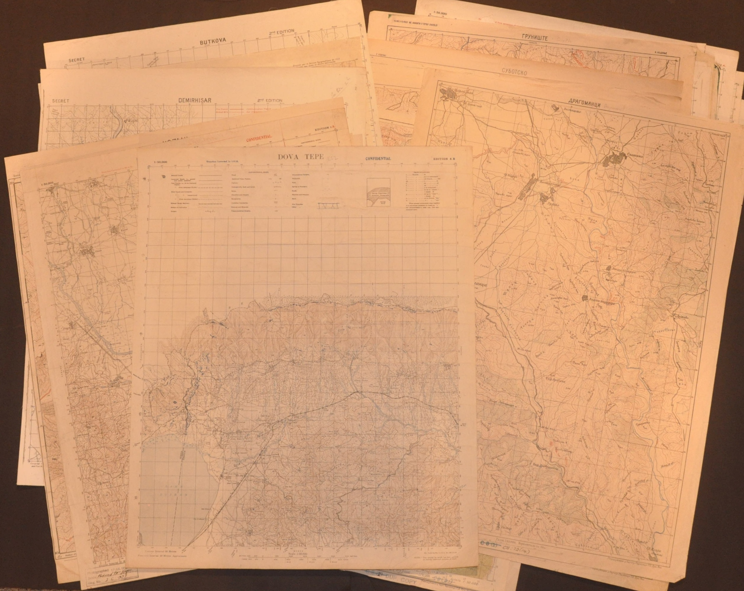
This rare collection of 36 topographic maps offers a detailed window into the ‘Forgotten Front’ of World War I. Covering the rugged, malaria-ridden, and often impassable terrain of Macedonia and Northern Greece, these military sheets document the strategic theater where the Entente’s Army of the Orient faced off against the forces of the Central Powers in a grueling stalemate that lasted from 1915 until the decisive breakthrough in 1918.
Unlike the flat, muddy trenches of the Western Front, the Macedonian (or Salonica) Front was defined by its punishing verticality and diverse ethnographic landscape. The maps capture this unforgiving terrain in extreme detail, at a scale of either 1:25,000 or 1:50,000. Serbian, French, and English authors present a mix of perspectives, languages, and mapmaking techniques, with several examples featuring overprinting of trench lines, manuscript updates, or other annotations.
Many of the important flashpoints of the theater are included within the collection, including:
- Three of four sheets covering Monastir (Bitola), the ‘Key to the Balkans’ that was liberated by the Allies in 1916, though it would remain under almost constant bombardment until the end of the war.
- Dobre Polje – The ‘Breakthrough at Dobro Polje’ occurred in September 1918 as part of the wider Vardar Offensive. At elevations exceeding 6,000 feet, Serbian and French forces executed a daring mountain offensive that finally shattered the Bulgarian lines, leading to the rapid collapse of the Central Powers’ southern flank.
- Several maps cover the The Moglenitsa Range, where several high-altitude confrontations required trenches to be blasted directly into the rock and supplies had to be hauled up via complex systems of mules and cableways.
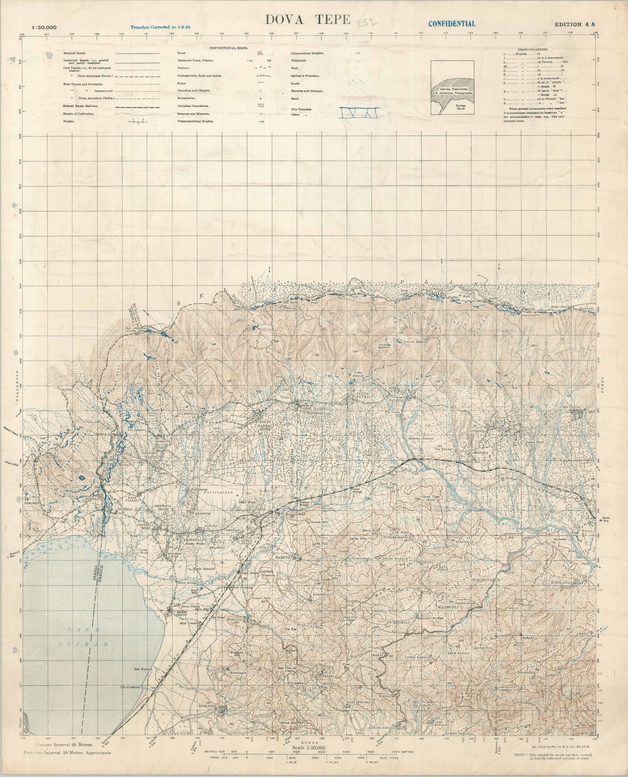
- Dova Tepe – Key terrain in the 1917 Battle of Dorian, which saw British forces endure heavy losses after repeatedly attacking fortified Bulgarian positions.
The maps have a unique provenance, having almost certainly been captured by British military intelligence during the campaign. Prior use is reflected in the aforementioned annotations and handwritten updates. Rubberstamps on numerous examples indicate they were received by the Map Room of the Geographical Section, General Staff (GSGS) and subsequently cataloged. During the 1980s, the GSGS underwent a significant downsizing effort and sold off much of it’s duplicative collection. An index of the available items is presented below, along with relevant details.
| Title | Modern Region | Language | Scale | Date | Author | Notes |
| [Gosteljebe] | Serbia | Cyrillic | 1:25,000 | N/A | [Map Workshop of the Supreme Army General Staff] | |
| [Caniste] | North Macedonia | Cyrillic | 1:25,000 | 1918 | [Map Workshop of the Supreme Army General Staff] | Marked Confidential; G.S.G.S. Stamps |
| [Polciste] | North Macedonia | Cyrillic | 1:25,000 | 1918 | [Map Workshop of the Supreme Army General Staff] | Marked Confidential; G.S.G.S. Stamps |
| [Topolats] | Serbia | Cyrillic | 1:25,000 | 1918 | [Map Workshop of the Supreme Army General Staff] | Marked Confidential; G.S.G.S. Stamps |
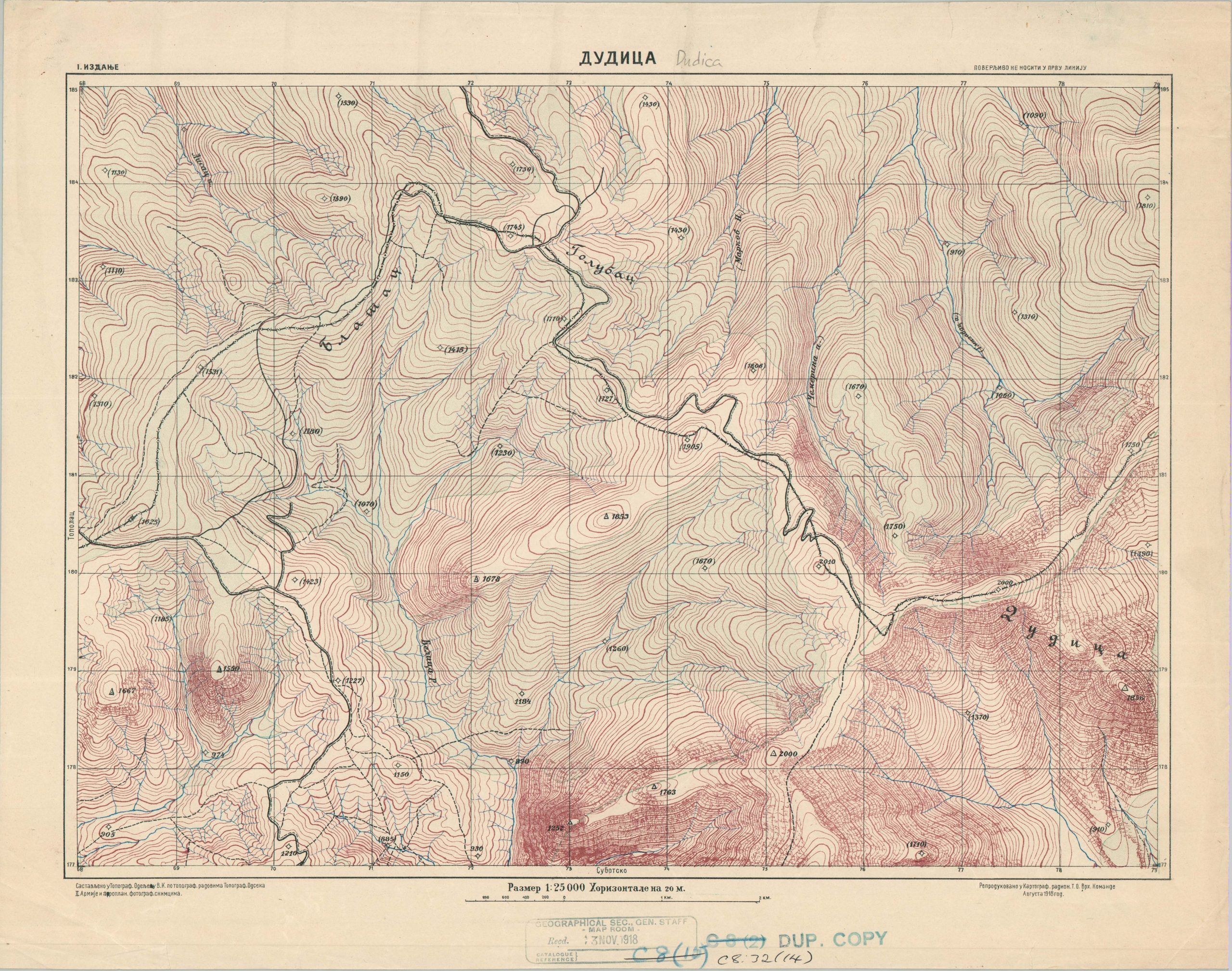
| [Dudica] | North Macedonia | Cyrillic | 1:25,000 | 1918 | [Map Workshop of the Supreme Army General Staff] | Marked Confidential; G.S.G.S. Stamps |
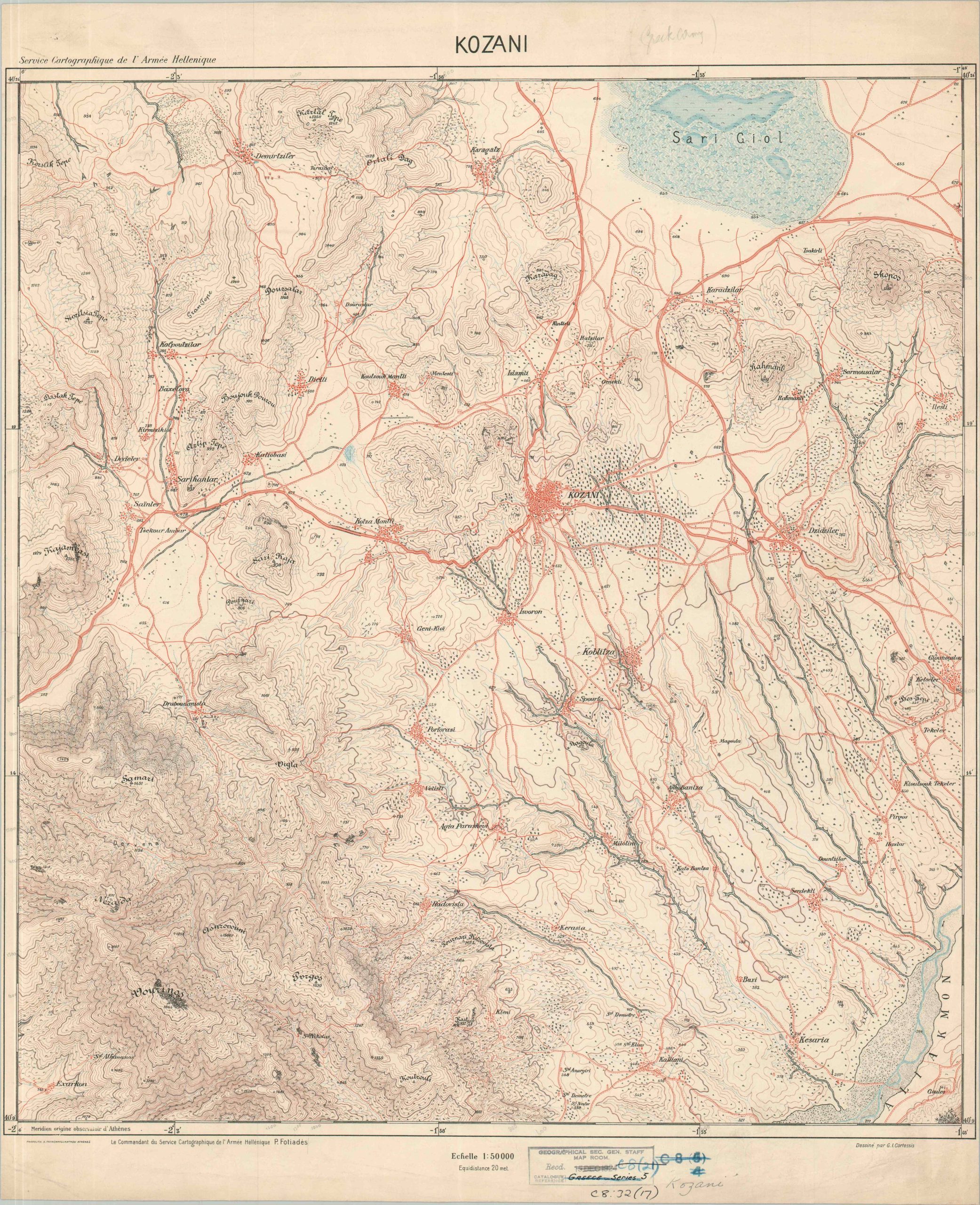
| Kozani | Greece | French | 1:50,000 | N/A | [Commander of the Cartographic Service of the Hellenic Army] | G.S.G.S. Stamps |
| Demirhisar | North Macedonia | English | 1:50,000 | 1916 | Royal Engineers Survey Section | Overprinting & addenda note trench lines & gun emplacements; G.S.G.S. stamps; |
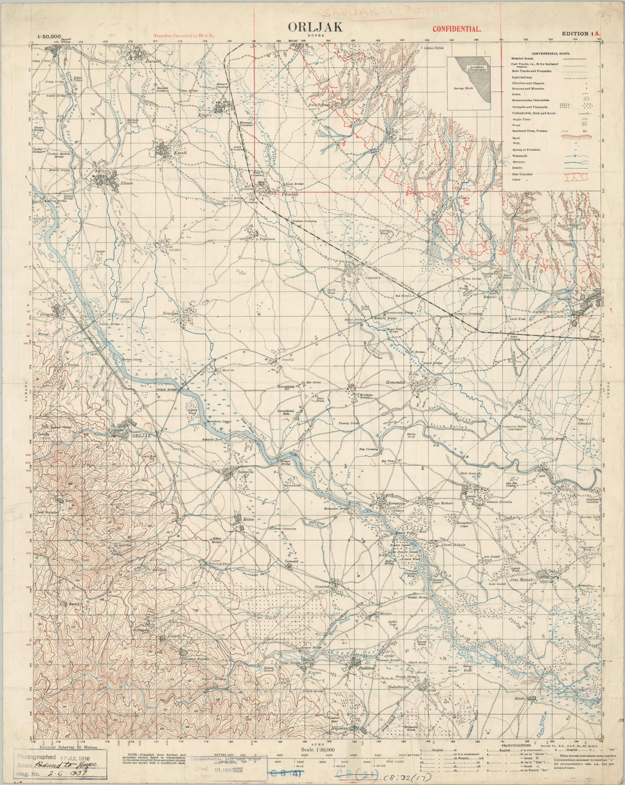
| Orljak | Greece | English | 1:50,000 | 1917 | Royal Engineers Survey Section |
Marked Confidential; Red overprinting notes corrected trench lines; G.S.G.S. stamps; Notable association with Rudolf von Eschwege
|
| Butkova | North Macedonia | English | 1:50,000 | 1916 | Royal Engineers Survey Section | Marked Secret; G.S.G.S. stamps |
| Suho | Greece | English | 1:50,000 | 1917 | Royal Engineers Survey Section | G.S.G.S. Stamps |
| Vrasta | Greece | English | 1:50,000 | 1918 | Royal Engineers Survey Section | |
| Dova Tepe | Greece | English | 1:50,000 | 1918 | Royal Engineers Survey Section | |
| Porna | Greece | English | 1:50,000 | 1917 | Royal Engineers Survey Section |
Marked Confidential; Red overprinting notes corrected trench lines; G.S.G.S. stamps;
|
| Monastir S.E. | North Macedonia | French | 1:50,000 | 1917 | [Survey and Artillery Grid Group of the French Armies in the East] | G.S.G.S. Stamps |
| Monastir S.O. | North Macedonia | French | 1:50,000 | 1917 | [Survey and Artillery Grid Group of the French Armies in the East] | G.S.G.S. Stamps |
| Monastir N.E. | North Macedonia | French | 1:50,000 | 1918 | [Survey and Artillery Grid Group of the French Armies in the East] | G.S.G.S. Stamps |
| Naoussa | Greece | French | 1:50,000 | 1918 | [Topographic Service of the Allied Armies] | G.S.G.S. Stamps |
| Verria | Greece | French | 1:50,000 | 1917 | [Topographic Service of the Allied Armies] | G.S.G.S. Stamps |
| Plati | Greece | French | 1:50,000 | 1917 | [Topographic Service of the Allied Armies] | G.S.G.S. Stamps |
| Kukus | Greece | French | 1:50,000 | 1916 | [Topographic Service of the Allied Armies] |
Red overprinting notes corrected trench lines; G.S.G.S. stamps;
|
| Topchi | Greece | French | 1:50,000 | 1916 | [Topographic Service of the Allied Armies] | G.S.G.S. Stamps |
| Kastoria | Greece | French | 1:50,000 | 1918 | [Topographic Service of the Allied Armies] | G.S.G.S. Stamps |
| Salonika | Greece | French | 1:50,000 | N/A | [Topographic Service of the Allied Armies] | Notes information supplied by H.M.S. Endeavour |
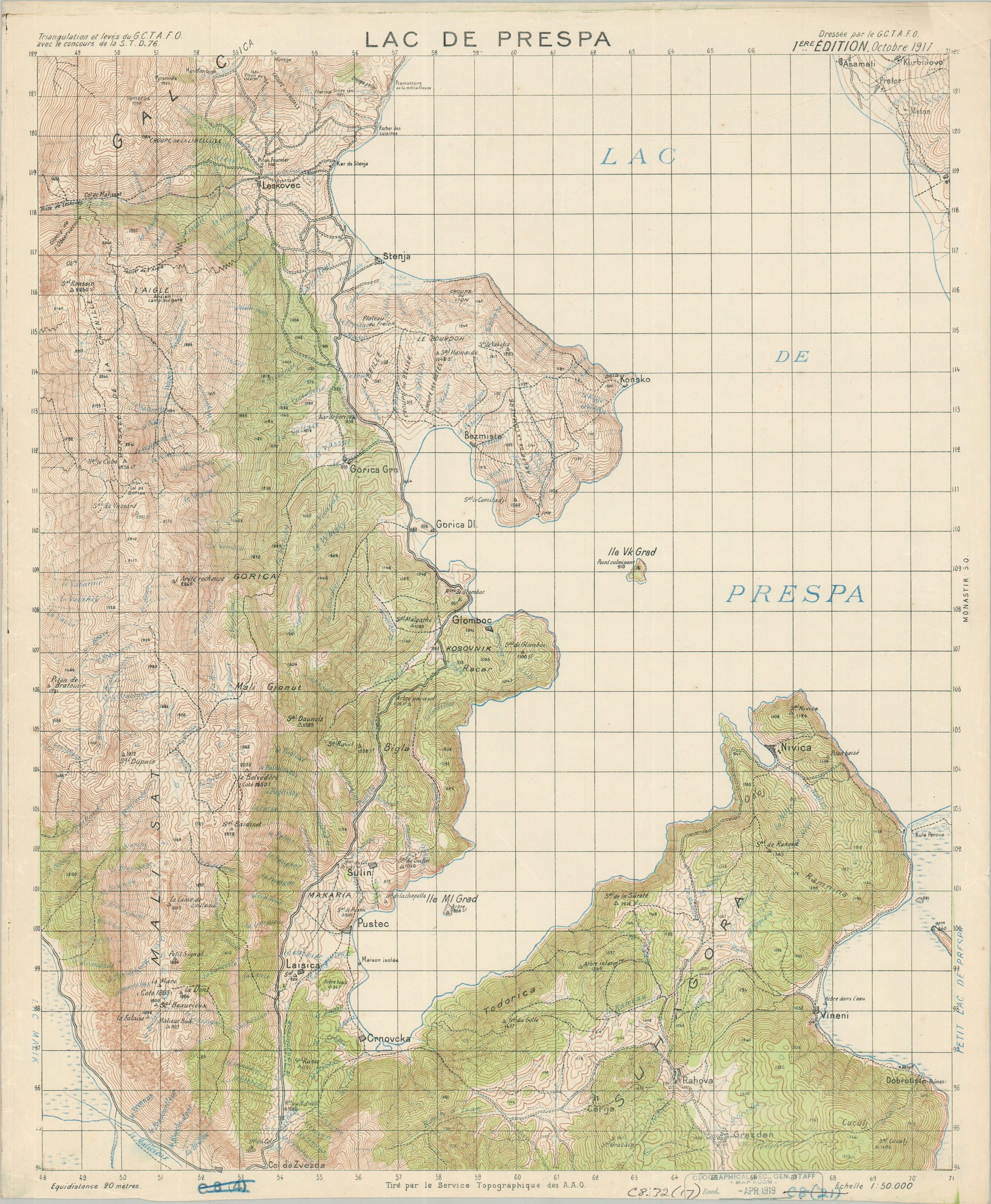
| Lac de Prespa | Greece | French | 1:50,000 | 1918 | [Topographic Service of the Allied Armies] |
G.S.G.S. Stamps; Two copies, one highlighting woods in green
|
| Korca (Korica) | Albania | French | 1:50,000 | 1918 | [Topographic Service of the Allied Armies] | G.S.G.S. Stamps |
| Livadi | Greece | French | 1:50,000 | 1917 | [Topographic Service of the Allied Armies] | G.S.G.S. Stamps |
| Biklista | Albania | French | 1:50,000 | 1918 | [Topographic Service of the Allied Armies] | G.S.G.S. Stamps |
| Dova Tepe | Greece | French | 1:50,000 | 1916 | [Topographic Service of the Allied Armies] |
Two editions (August and September), Red overprinting notes corrected trench lines; G.S.G.S. stamps;
|
| [Moglenitsa] | Serbia | Cyrillic | 1:50,000 | 1918 | [Map Workshop of the Supreme Army General Staff] |
Marked Confidential; Notable for the Battle of Dobro Pole
|
| Gruniste | Serbia | Cyrillic | 1:25,000 | 1918 | [Map Workshop of the Supreme Army General Staff] |
Marked Confidential; G.S.G.S. Stamps; Red overprinting notes the Bulgarian fortified lines;
|
| Soko – Dobro Polje | Serbia | Cyrillic | 1:25,000 | 1918 | [Map Workshop of the Supreme Army General Staff] |
Marked Confidential; G.S.G.S. Stamps; Red overprinting notes the Bulgarian fortified lines;
|
| Veternik | Serbia | Cyrillic | 1:25,000 | 1918 | [Map Workshop of the Supreme Army General Staff] |
Marked Confidential; Red overprinting notes the Bulgarian fortified lines;
|
| Subotsko | North Macedonia | Cyrillic | 1:25,000 | 1918 | [Map Workshop of the Supreme Army General Staff] |
Marked Confidential; G.S.G.S. Stamps; Red overprinting notes the Bulgarian fortified lines; Two copies (one lacking overprints)
|
| Dragomanci | North Macedonia | Cyrillic | 1:25,000 | N/A | [Map Workshop of the Supreme Army General Staff] | G.S.G.S. Stamps |
| Pajik | Greece | Cyrillic | 1:25,000 | N/A | [Map Workshop of the Supreme Army General Staff] | G.S.G.S. Stamps |
| Tresina | Greece | Cyrillic | 1:25,000 | N/A | [Map Workshop of the Supreme Army General Staff] | G.S.G.S. Stamps |
Map Details
Publication Date: 1916 - 1918
Author: Various
Sheet Width (in): 19.75
Sheet Height (in): 24.25
Condition: B+
Condition Description: Collection of thirty-six topographic maps on sheets of approximately the same size created by a variety of military authorities, captured by the British during the war. Maps show varying signs of wear and use, including edge tears, manuscript annotations (pencil, blue ink, etc.), creased corners, rubberstamps, and scattered soiling and dampstaining. Generally, conditions range from above fair to very good.
$5,200.00
1 in stock