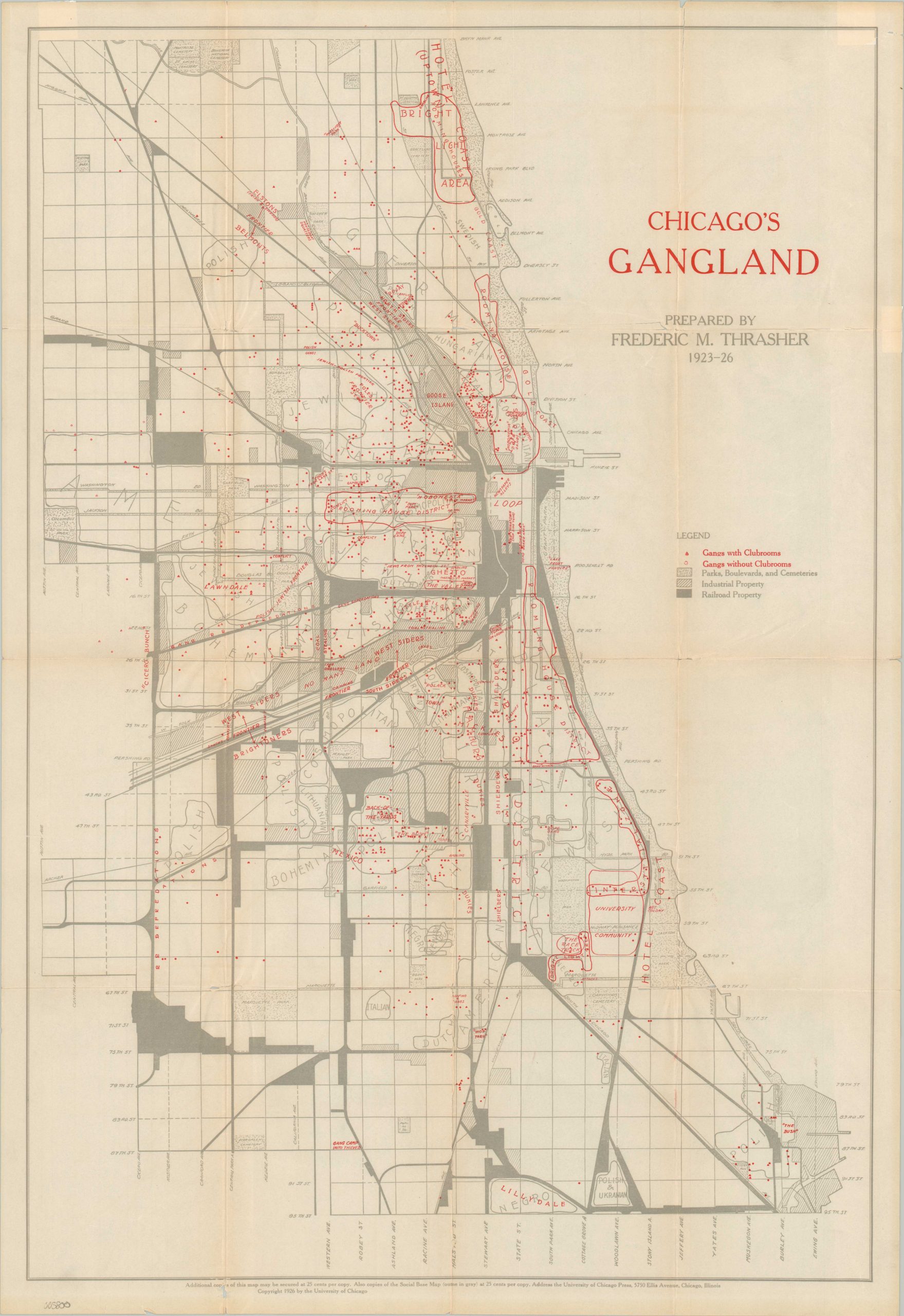
Chicago’s Gangland
Chicago’s Gangland during Prohibition.
Out of stock
Description
This tremendous map decrying the morals of Chicagoland during the Roaring 20’s was published in 1927 by Frederic M. Thrasher to accompanying his seminal work, The Gang: A Study of 1,313 Gangs in Chicago. As a professor of sociology at Illinois Wesleyan and ‘Sometime Fellow’ at the University of Chicago, Thrasher played a pivotal role in developing the Chicago school of thought combining the study of urban environments and criminology.
To understand the map, it’s necessary to examine the accompanying text, which is broken into four parts; The Natural History of the Gang, Life in the Gang, Organization and Control in the Gange, and the Gang Problem. Throughout, the book explores the relationship between race, immigration status, socio-economic factors, housing, industry, and various cultural elements.
In Thrasher’s eyes, ‘Gangland’ was divided into “three great domains, each of which in turn breaks up into smaller kingdoms.” These he called the ‘North Side jungles’, West Side wilderness’, and ‘South Side badlands’; each lying in a semi-circle around the city’s central business district, the Loop [Thrasher, pg. 6]. Each of these generalized regions fall within the proverbial ‘cracks’ of Chicago, with fissures taking the form of impassable railroads, thick belts of industrial development, and inherent cultural/racial phenomena.
“The central tripartite empire of the gang occupies what is often called “the poverty belt” – a region characterized by deteriorating neighborhoods, shifting populations, and the mobility and disorganization of the slum. Abandoned by those seeking homes in the better residential districts, encroached upon by business and industry, this zone is a distinctly interstitial phase of the city’s growth. It is to a large extent isolated from the wider culture of the larger community by the processes of competition and conflict which have resulted in the selection of its population.” [Thrasher, pg. 22-23].
With Thrasher’s central thesis in mind; the various highlighted regions, dots, and outlined areas within the map begin to coalesce into a unified argument for significant social change. Though broadly generalized, regions identified as distinctively ethnic (as opposed to cosmopolitan) have visibly higher rates of gang activity. Gangs are clustered along the edges of industrial property and railroads, and proximity to the city is clearly a priority. Numerous individual entries make for a fascinating patchwork of criminality at the height of Prohibition and the Al Capone era of Chicago.
Map Details
Publication Date: 1927
Author: Frederic Thrasher
Sheet Width (in): 18.4
Sheet Height (in): 26.75
Condition: B+
Condition Description: Printed on brittle paper that has toned and separated in several areas along originally issued fold lines. Repaired on the verso with archival tape with minimal image loss. One irregular closed tear in the upper right corner also repaired as such. Good to very good condition overall.
Out of stock

