Carte Genealogique Pour Conduir a L’Histoire des Rois du Nord, la Carte de Leurs Etats, Leurs Armes et Des Remarques Pour Conduire a L’Intelligence de L’Histoire du Nord
$200.00
The Kings of the North during the Great Northern War.
1 in stock
Description
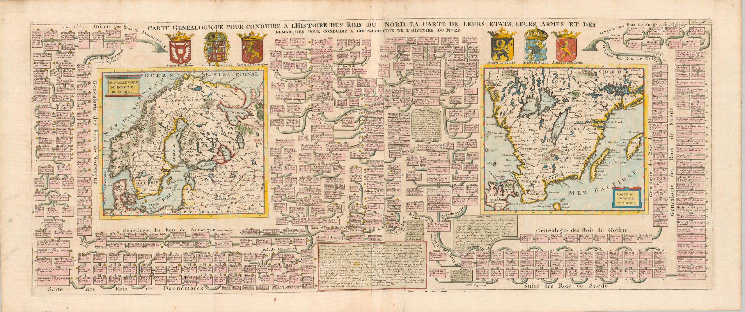
Genealogical Map to Lead to the History of the Kings of the North, the Map of Their States, Their Arms and Remarks to Lead to the Understanding of the History of the North – Approximate title translation.
This fascinating sheet tells a visual history of Scandinavian royal identity. The lineage of the Kingdoms of Denmark, Norway, and Sweden can be traced across a complex family tree dating back centuries (much of it speculative or legendary). A few noteworthy monarchs include King Canute II and Queen Christina.
The latter’s father, Gustavus Adolphus, died when she was six, though she would rule if official capacity as queen until 18. Christina was well-educated and a huge patron of the arts and sciences, but her ego and spendthrift ways made her unpopular. She refused to marry and converted to Catholicism, relinquishing the throne to her cousin, Carl X Gustav. She was a potent symbol of the Counter-Reformation (one of few women buried in the Vatican Grottoes) and popularly known for wearing men’s clothes.
Two maps show the extent of the Kingdom of Sweden, the dominant regional power then under assault by Russia, Norway, and Denmark during the Great Northern War. The image on the right shows the southernmost province of Götaland.
The copperplate-engraved sheet was originally published in Paris as part of Henri Abraham Chatelain’s important Atlas Historique. This monumental seven-volume set was first issued in Amsterdam between 1705 and 1720, but was reprinted in numerous editions until the late 1730s. The scholarly, but approachable, work was aimed at a broad audience, eager for new information during the Age of Enlightenment. The breadth of content offers a nuanced synthesis of geography, cosmography, history, religion, ethnology, and political science. The descriptive text (in French) and skillfully engraved maps, diagrams, and illustrations provide a fascinating window into the world of the early 18th century.
Map Details
Publication Date: c. 1720
Author: Henri Abraham Chatelain
Sheet Width (in): 43.5
Sheet Height (in): 21.3
Condition: A-
Condition Description: Large copperplate engraved sheet with attractive modern hand color, sharply creased along original fold lines. A nice impression on a strong sheet of watermarked paper. Light wear and scattered spotting mostly visible in the margins. Small worm or binding holes affect the smaller text in the title block and there is some faint toning and offsetting within the image (see scan). Good to very good condition overall.
$200.00
1 in stock