California
$1,800.00
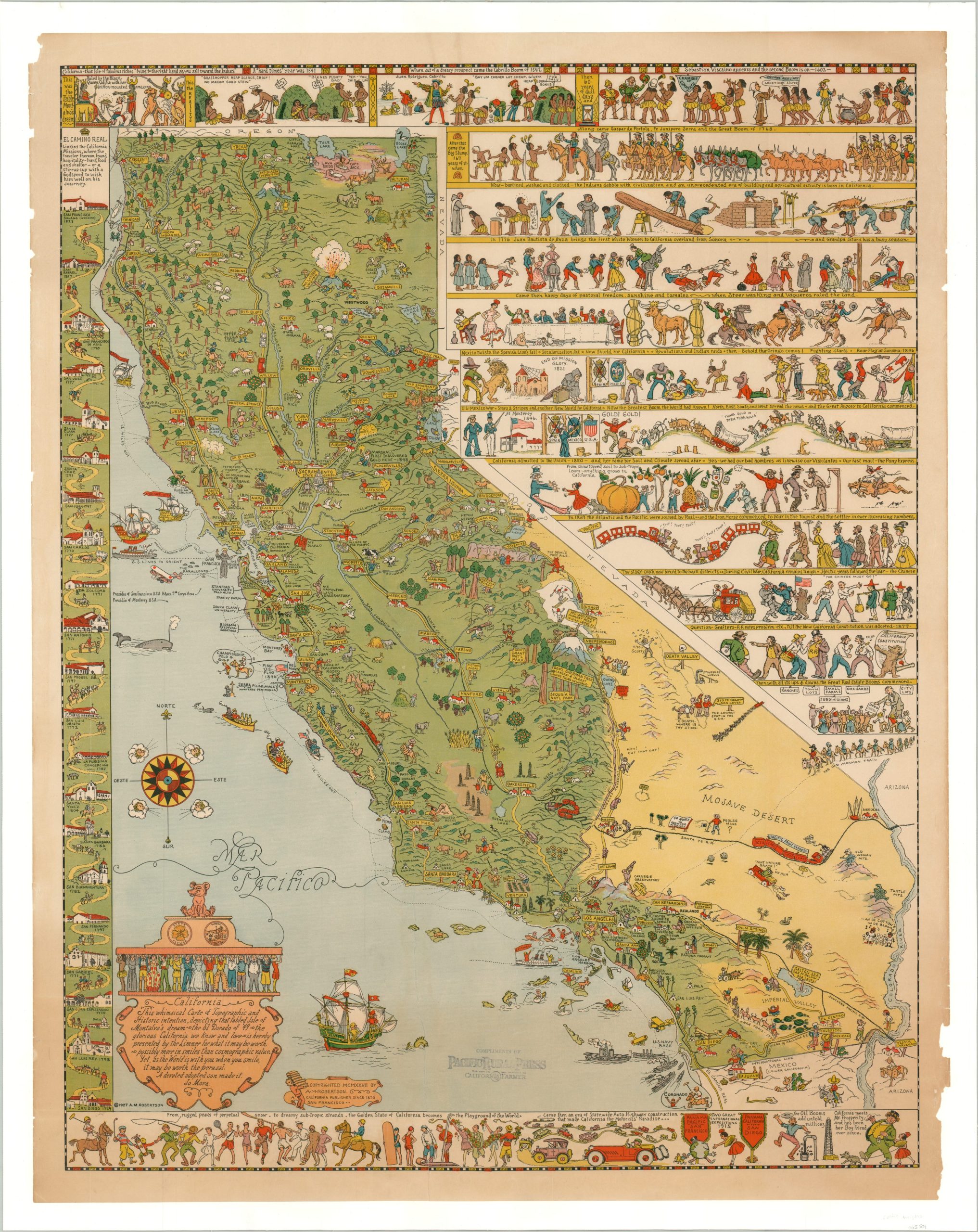
First edition of Jo Mora’s breathtaking pictorial map of California.
1 in stock
Description
“This whimsical Carte of Topographic and Historic intention, depicting that fabled Isle of Montalvo’s dream – the El Dorado of ’49 – the glorious California we know and love – is hereby presented by the Limmer for what it may be worth – possibly more in smiles than cosmographic value. Yet, as the world is with you when you smile, it may be worth the perusal. A devoted and adopted son made it.” – Jo Mora, text in the lower left.
This phenomenal pictorial map of California was created by the talented Jo Mora in 1927 – the first and best of his ‘cartes’ representing the state. The image is anchored by a carefully drawn map of California that uses vibrant colors to exaggerate the differences in landscape between the Mojave and the rest of the state. Major towns are connected by an inexact network of roads and their navigational accuracy is suspect, at best. Numerous vignettes emphasize cultural, historical, and industrial sites throughout, often injected with Mora’s clever sense of humor and wit.
That same characteristic style can be found in the illustrated panels that surround the map. The left side presents an interesting strip route showing various missions along the ‘El Camino Real’ between San Francisco and San Diego. The upper right shows a satirical, though surprisingly equitable, summary of California’s history from the time of its original indigenous inhabitants to the real estate booms of the 20th (and 21st) centuries. The bottom of the sheet presents a number of figures engaged in recreational activities, with the accompanying text “from rugged peaks of perpetual snow to dream sub-tropic strands, the Golden State of California becomes the playground of the world.”
Designed by Jo Mora and published by A.M. Robertson in 1927. A slightly faded rubberstamp near the bottom indicates this example was distributed by the Pacific Rural Press Company of San Francisco. All of Mora’s maps are uncommon on the market and exceptionally popular among collectors, but few such as the first edition of California.
According to the Jo Mora Trust;
“Few artistic legacies are more interesting than that of Joseph Jacinto Mora (1876−1947). Mora’s artistic gifts range over a wide variety of mediums, including drawing, painting, illustration, cartooning, sculpture, photography, map-making, and writing, their diversity being an amazing accomplishment for one person.
Mora was born in Uruguay on October 22, 1876, moved to the eastern United States when he was a young child, and then, after attending art school and working as an illustrator and cartoonist in the Boston area, spent the rest of his adult life living and working in the western United States, with the last 27 years in Carmel and Pebble Beach, California…Mora is probably best known publicly for the series of maps – or cartes, as he referred to them – that he created. These historically accurate, humorous, and collectible prints have entertained viewers for years.”
Map Details
Publication Date: 1927
Author: Jo Mora
Sheet Width (in): 27.60
Sheet Height (in): 35.25
Condition: A-
Condition Description: Professionally mounted on linen for preservation and stability. The sheet is lightly toned and shows a bit of marginal wear, including a few small chips in the lower right side. Remains in very good condition overall, with vibrant color. Publisher's stamp visible in the lower center.
$1,800.00
1 in stock