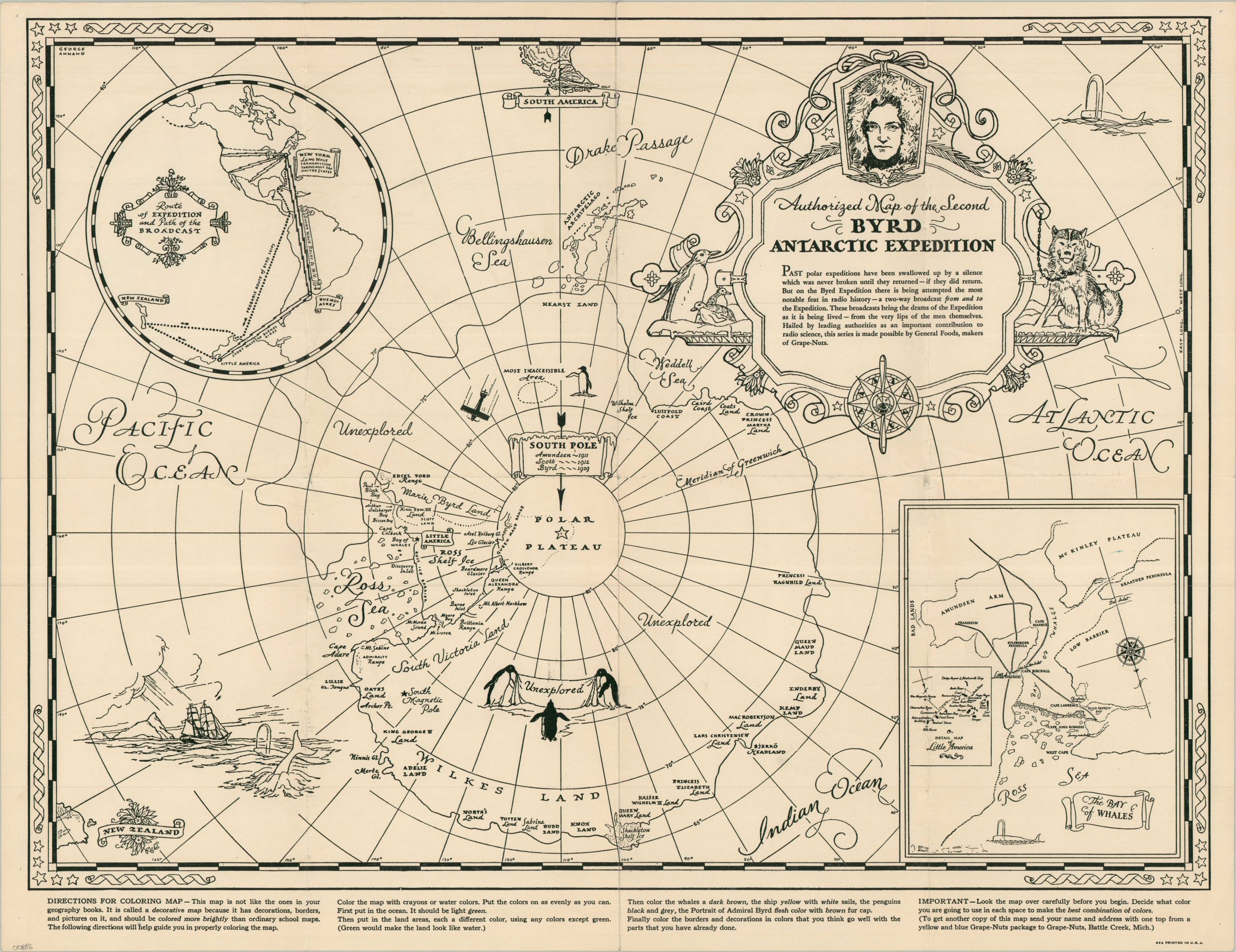
Authorized Map of the Second Byrd Antarctic Expedition
$225.00
An uncommon variant on a promotional map celebrating Byrd’s Second Antarctic Expedition.
1 in stock
Description
Past polar expeditions have been swallowed up by a silence which was never broken until they returned – if they returned. But on the Byrd Expedition, there is being attempted the most notable feat in radio history – a two-way broadcast to and from the Expedition…Hailed by leading authorities as an important contribution to radio science, this series is made possible by General Foods, maker of Grape Nuts.” – Text, upper right
This lively black and white polar map was illustrated by the talented George Annand and published in 1934, during the Second Polar Expedition (1933-1935) led by Admiral Richard E. Byrd. It depicts Antarctica from a polar perspective, with the tip of South America visible at the very top of the image. Large areas are labeled as unexplored, inaccessible, or “claimed.” Inset maps of Byrd’s route south and the area near his camp are provided to the audience as a helpful aid. As explained in the decorative title cartouche, Byrd’s second expedition was the first to feature live two-way radio broadcasts. A radio station sponsored by CBS was set up on the base camp ship and relayed weekly updates to New York via Buenos Aires. Grape Nuts were among the provisions brought by Byrd and his team, hence the partnership with General Foods.
Byrd’s Second Antarctic Expedition was organized to expand scientific research and further explore the continent of Antarctica, building on the achievements of his earlier venture. Centered at Little America II on the Ross Ice Shelf, the expedition conducted extensive studies in meteorology, geology, biology, and glaciology while improving radio communications and aerial surveying techniques. Admiral Richard E. Byrd gained particular notoriety for spending several months alone at an advance weather station, an ordeal that nearly cost him his life due to carbon monoxide poisoning.
The map was issued in two forms – one with full printed color and one in black and white (designed to be colored by the audience). This is an example of the latter, which is less common on the market and in institutional collections.
Sources: Rumsey 8133.000; Encyclopedia Virginia; AdmiralByrd.com;
Map Details
Publication Date: 1934
Author: George Annand
Sheet Width (in): 24.00
Sheet Height (in): 18.25
Condition: A-
Condition Description: Single-sided black & white map with some light creasing along old folds and pinholes in the corners. Very good condition overall.
$225.00
1 in stock