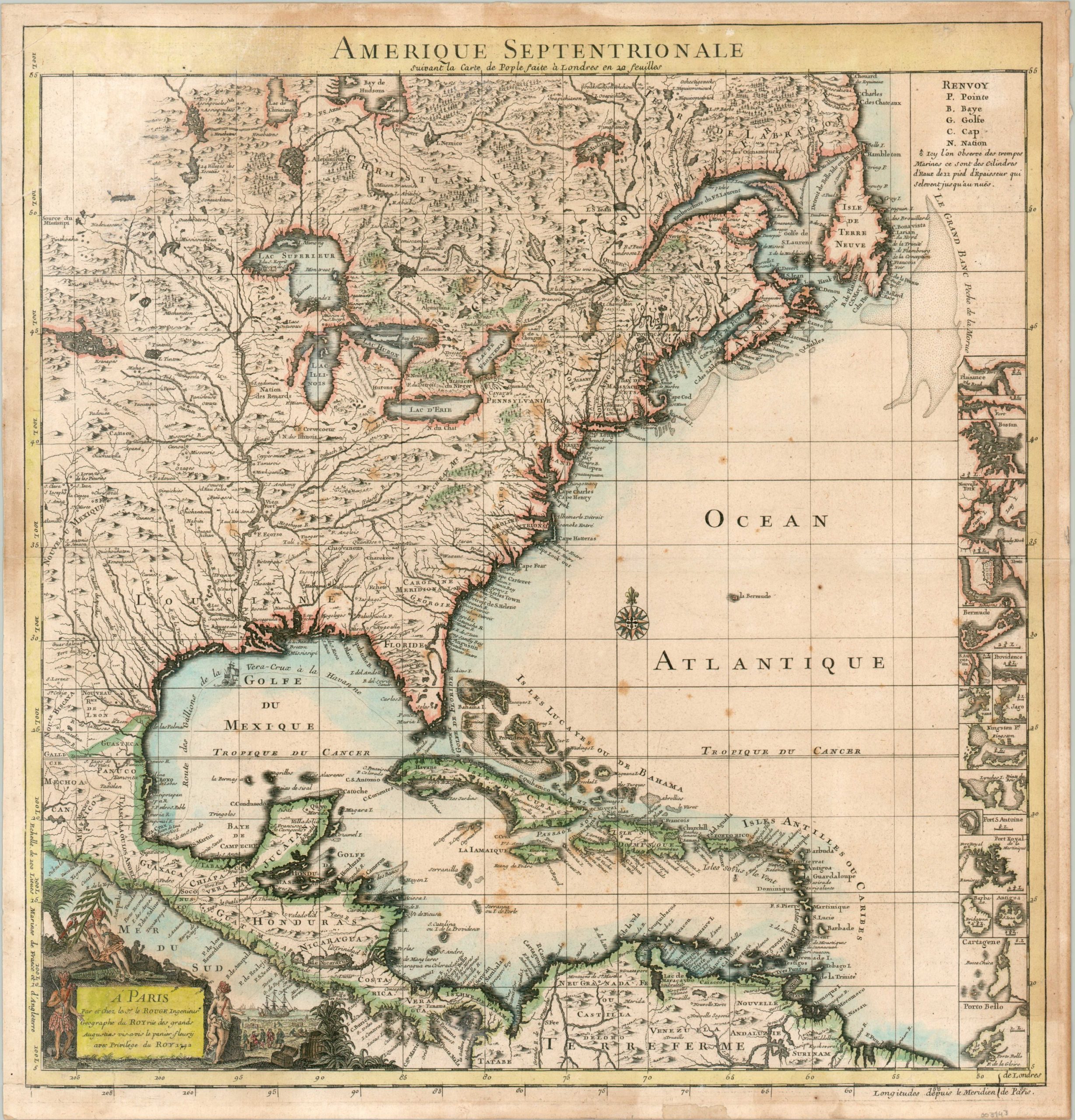
Amerique Septentrionale suivant la Aarte de Pople faite a Londres en 20 feuilles.
North America just over a decade before the outbreak of the French and Indian War.
Out of stock
Description
In 1730, the English Board of Trade & Plantations issued a request for maps of the British, French, and Spanish territorial claims in the New World, as ongoing boundary conflicts hindered economic development in the colonies. A former employee, Henry Popple, created an incredible 20-sheet map first published in 1733 that covered a broad region between Hudson Bay and the northern coast of South America and inland as far as the Rio Grande. It would become tremendously influential diplomatically as disputes among European powers increased dramatically in subsequent decades.
Accompanying the monumental production was a keymap, seen here as a later French edition issued by Georges Louis Le Rouge in 1742. With the exception of the language, decorative elements, annotations, and a missing vignette in the upper left corner, the image is largely the same as the original. It’s surprisingly accurate, as Popple was studious in his use of the latest available sources, though several geographic features have been enlarged or distorted and a large mysterious lake filled with islands appears near the western edge of the sheet.
It’s likely this is a remnant of the great saline sea speculated by Baron Lahontan, a French military officer who traveled extensively throughout the Great Lakes region from 1684 -1689. He later wrote several popular travel volumes that included reports of a Long (or Longue) River that branched from the Missippi westward, eventually reaching a large salt lake at the foot of a mountain range. The geographic influences of his story would be reflected in subsequent cartographic efforts throughout the 18th and into the early 19th century, and speculation on Lahontan’s travels persists to this day.
Elsewhere in the image, the topography is depicted pictorially and shows a prominent Appalachian Mountain range as well as a curious plateau in Michigan that Lewis Karpinski describes as a “fanciful creation.” Native American and European settlements are identified throughout and geographic features are labeled according to the key in the upper right. Seventeen inset plans of prominent port cities and islands can be seen in the lower right; including Boston, Charleston, New York, St. Augustine, Havana, and Cartagena.
Sources: Goss, 55; McCorkle #742.2; Canadian Museum of History
Map Details
Publication Date: 1742
Author: Georges Louis Le Rouge
Sheet Width (in): 19.75
Sheet Height (in): 20.7
Condition: B+
Condition Description: Trimmed margins and the upper left corner has been professionally re-attached and restored. Scattered spotting visible throughout the image. Moderate wear in the margins, including some staining and additional professional repairs. Good to very good overall, with attractive hand color.
Out of stock

