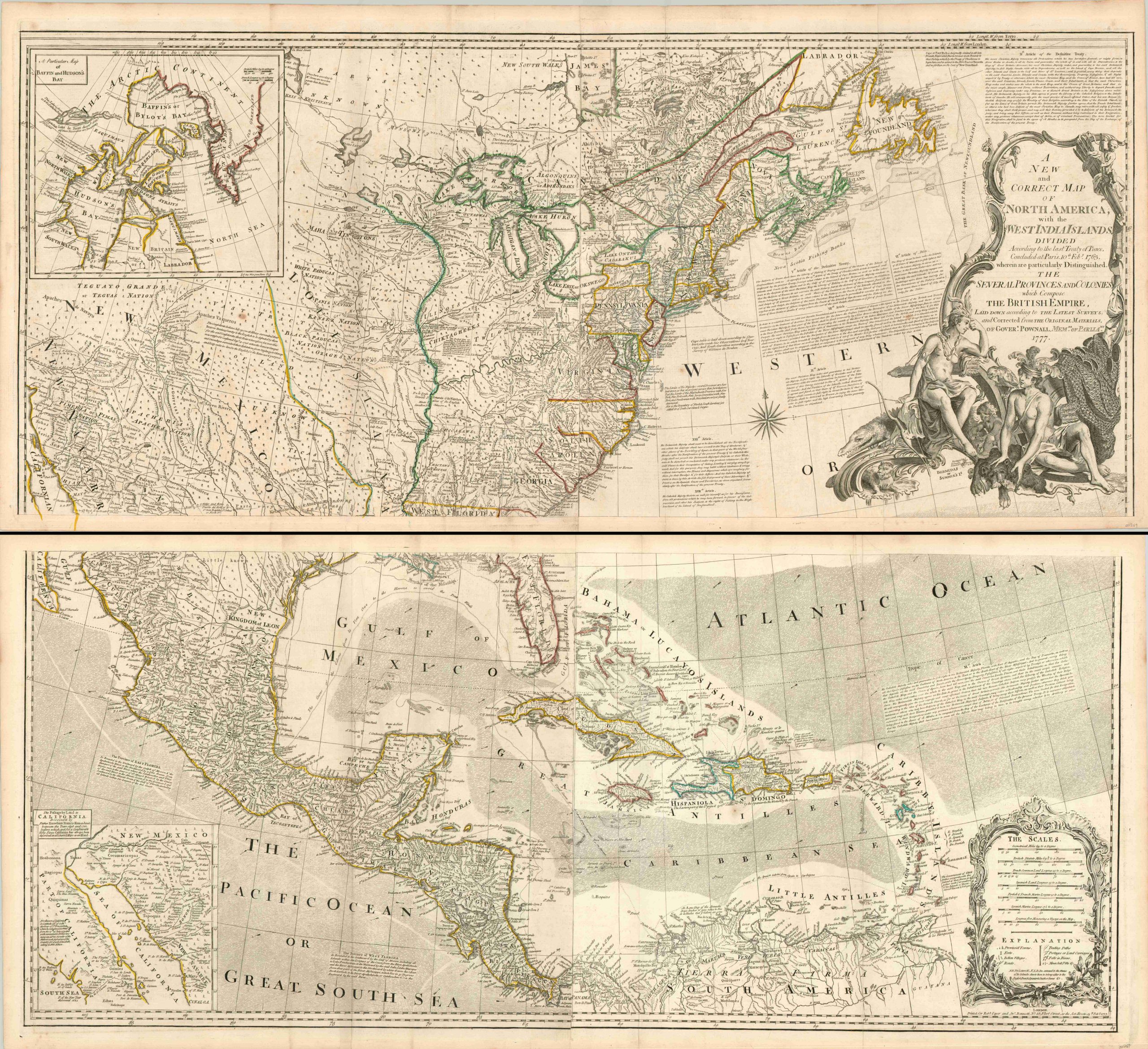
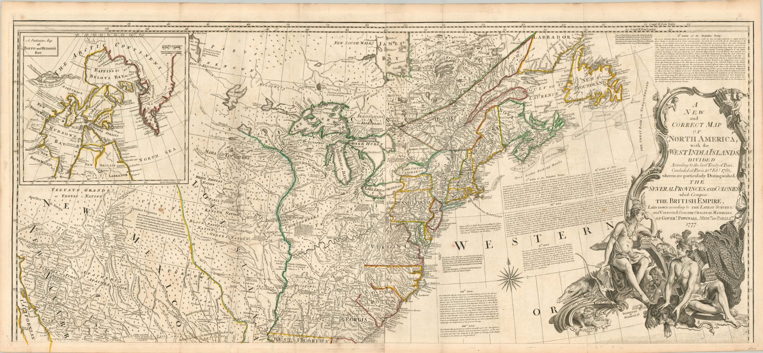
A New and Correct Map of North America with the West India Islands…Which Compose the British Empire
A cornerstone map for collectors of the American colonial period.
Out of stock
Description
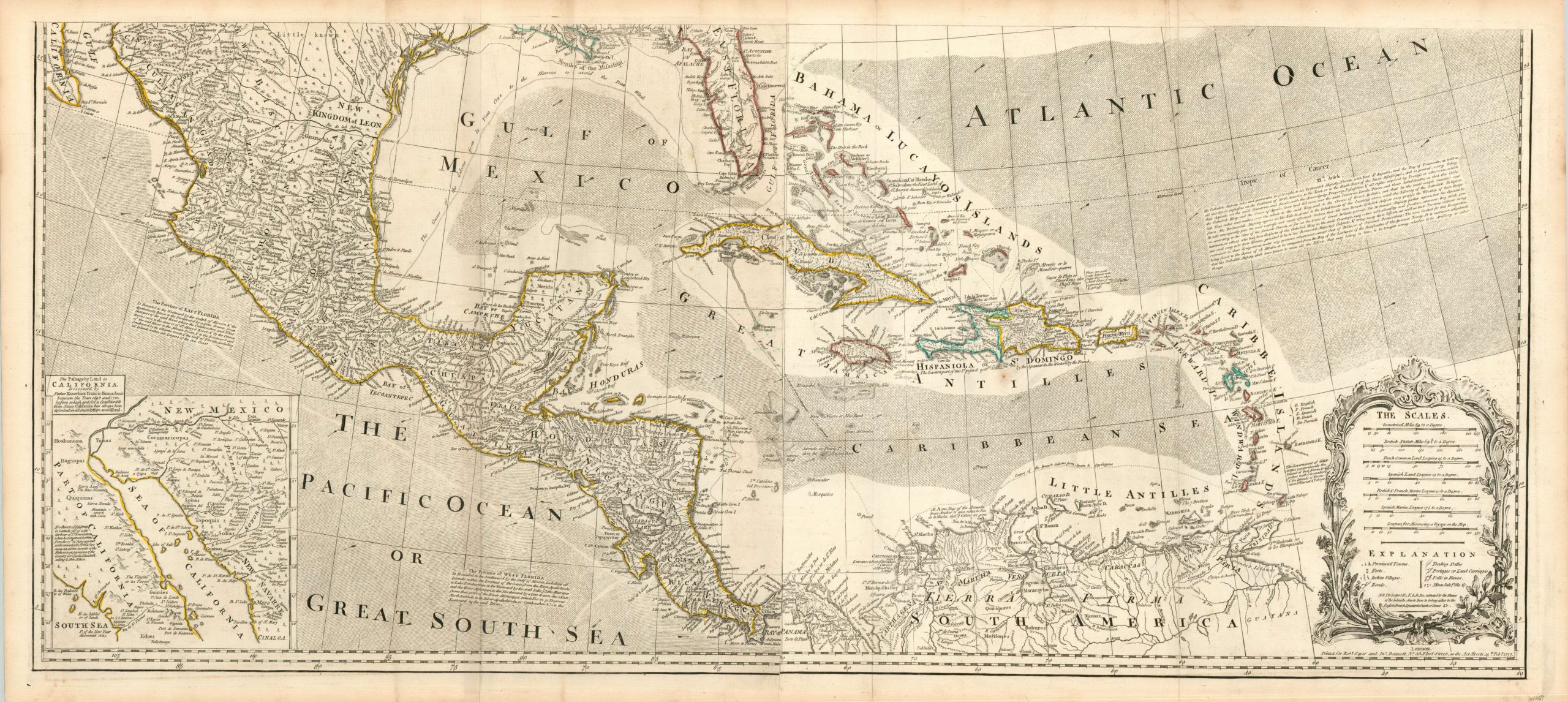
This monumental four sheet map was first issued in 1755 by the English firm of Bowen & Gibson and was periodically updated in the subsequent decades after the conclusion of the French and Indian War in 1763. This particular example is the first issue incorporating the improvements proposed by Governor Thomas Pownall, and was published shortly after the start of the Revolutionary War in 1777. Pownall (1722 – 1805) served as Secretary to the Governor of New York, and he himself as the Governor of Massachusetts Bay Colony.
The map is based on his own observations and surveys, as well as the works of John Mitchell and indigenous sources. The image reflects the rapidly changing colonial situation in late 18th century North America, with various territorial claims identified and highlighted in outline color. Changes according to the terms of the Treaty of Paris (1763) are noted; such as the western limits of Virginia and the Carolinas ending at the Appalachians, rather than the Mississippi River. The Spanish, French and English Empires are all clearly defined, though the precise nature of those definitions would change drastically over the course of the next few years.
Two inset maps are provided and both approach some of the most persistent cartographic myths of the era. The lower left inset shows the peninsula of Baja California, crediting the exploration of Jesuit Father Francis Kino and laying to rest the persistent idea that California may be an island. The upper inset map shows the Hudson’s Bay in further detail, noting that if the fabled Northwest Passage did exist, it would be through a small inlet in the frozen Arctic Circle.
Elsewhere one can find the course of the Spanish treasure galleons, countless Native American villages, portages, forts, mines, and prominent geographic features – all providing a fascinating snapshot of the North American continent at the outbreak of the Revolutionary War. The content of the map itself is enough to occupy a reader for some time, but in addition, the full text from several articles of the Treaty of Paris are included in the negative space. Prevailing winds are highlighted in the Caribbean and numerous annotations provide additional context on provincial histories, Native American tribes, and territorial claims.
Two large, decorative cartouches are also featured. The title cartouche includes two romanticized American Indians who would likely appear more at home in South America, based on the monkeys and parrots surrounding them. The secondary rococo cartouche surrounds seven different scale bars and a key identifying various symbols used on the map; including letters indicating if a particular area belongs to the English, French, Spaniards, Dutch, or Danes.
A fantastic example of this important map of colonial North America. References: Stevens, Henry N. & Tree, Roland. (1967). Comparative cartography (# 49). London : Map Collectors’ Circle
Map Details
Publication Date: 1777
Author: Thomas Pownall
Sheet Width (in): See Description
Sheet Height (in): See Description
Condition: B+
Condition Description: Printed on four large sheets. Two pairs have been combined, each measuring 48" x 21.5." Features original outline color. Creasing along fold lines and toning in the margins consistent with age. One large 6" tear in the lower sheet in the Atlantic Ocean, repaired on verso. Some faint blue ink offsetting in the Caribbean and a few scattered spots of foxing in the upper sheet. Both sheets are in excellent condition, and could be joined.
Out of stock