A Map of the State of Vermont Drawn under the Direction of Ira Allen, Esquire
An uncommon and unusual persuasive map of Vermont from the late 18th century.
Out of stock
Description
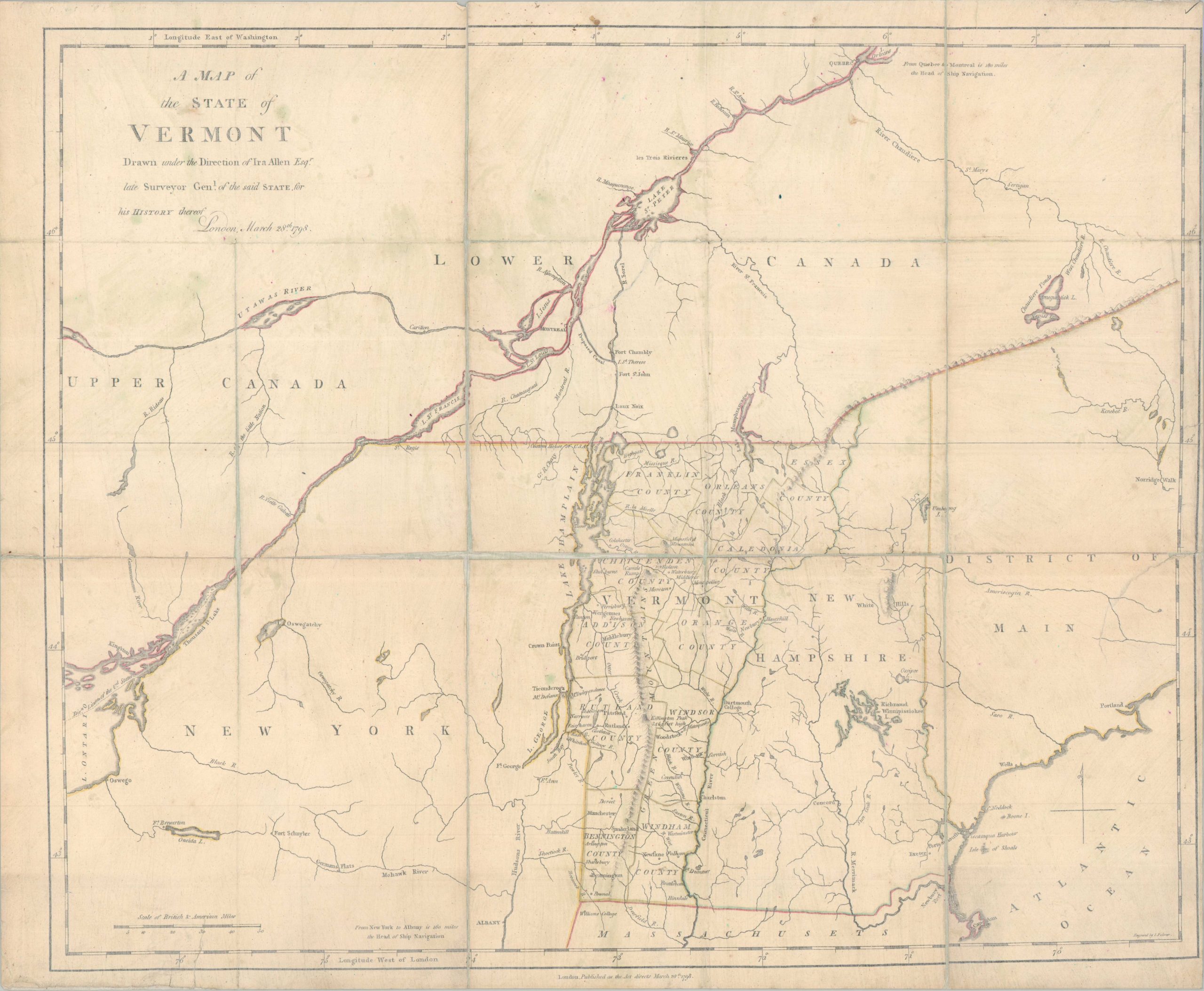
This fascinating map of the newly established state of Vermont was designed by Ira Allen for inclusion in his important 1798 work, The Natural and Political History of the State of Vermont. A rather unusual image, engraved by I. Palmer (signed, lower right), presents a detailed overview of a large region centered around Lake Champlain. Apart from the growing network of settlements, concentrated along the state’s numerous waterways, there is a fascinating variety of toponyms that reflect contemporary priorities of an embryonic sovereign nation. The custom house is labeled at Alburgh along a clearly delineated national boundary, navigational lines are noted in Lake Ontario, and various forts highlight battlegrounds of the Revolution. Dartmouth College and Williams College (in adjacent Massachusetts) are also labeled.
Pictorial topography results in a prominent Green Mountain range, while the adjacent White Hills of New Hampshire are significantly smaller. Though ostensibly focused on Vermont, the image is deliberately expanded to include large parts of adjacent Maine, New York, and British Canada, with the latter emphasizing the critical thoroughfare of the St. Lawrence River. A curious (and ultimately unrealized) ‘Proposed Canal’ is connected at the east bank near Montreal to the River Sorel (Richelieu River).
This was a vital component of the mapmaker’s message. Allen was desperately trying to convince the audience that Vermont was perfectly situated in a unique geographic position, accessible to the St. Lawrence, Atlantic Coast, and Hudson River. In a nutshell, Ira Allen wrote his 1798 treatise primarily as a defensive legal and political maneuver while he was detained in London following the “Olive Branch” affair. By detailing Vermont’s struggle for independence and its unique geographic resources, Allen sought to establish the state’s legitimacy (and celebrate his foundational role) to a skeptical British audience. Crucially, the book served as a public relations tool intended to secure British support for a proposed canal linking Lake Champlain to the St. Lawrence River, a project vital to Allen’s personal land holdings and Vermont’s economic future.
Sources: McCorkle, New England in Early Printed Maps; National Archives; Boston Rare Maps;
Map Details
Publication Date: 1798
Author: Ira Allen
Sheet Width (in): 22.60
Sheet Height (in): 18.60
Condition: B-
Condition Description: A fair to good copy, with inelegant archival repairs that consist of the dissected map complete covered with Japanese tissue on both sides of the sheet. This has repaired some closed edge tears and halted any further deterioration, but the image and original outline color look somewhat faded and washed. Furthermore, there appears to be some surface streaking under the top layer of tissue, further discoloring the page (see scan).
Out of stock