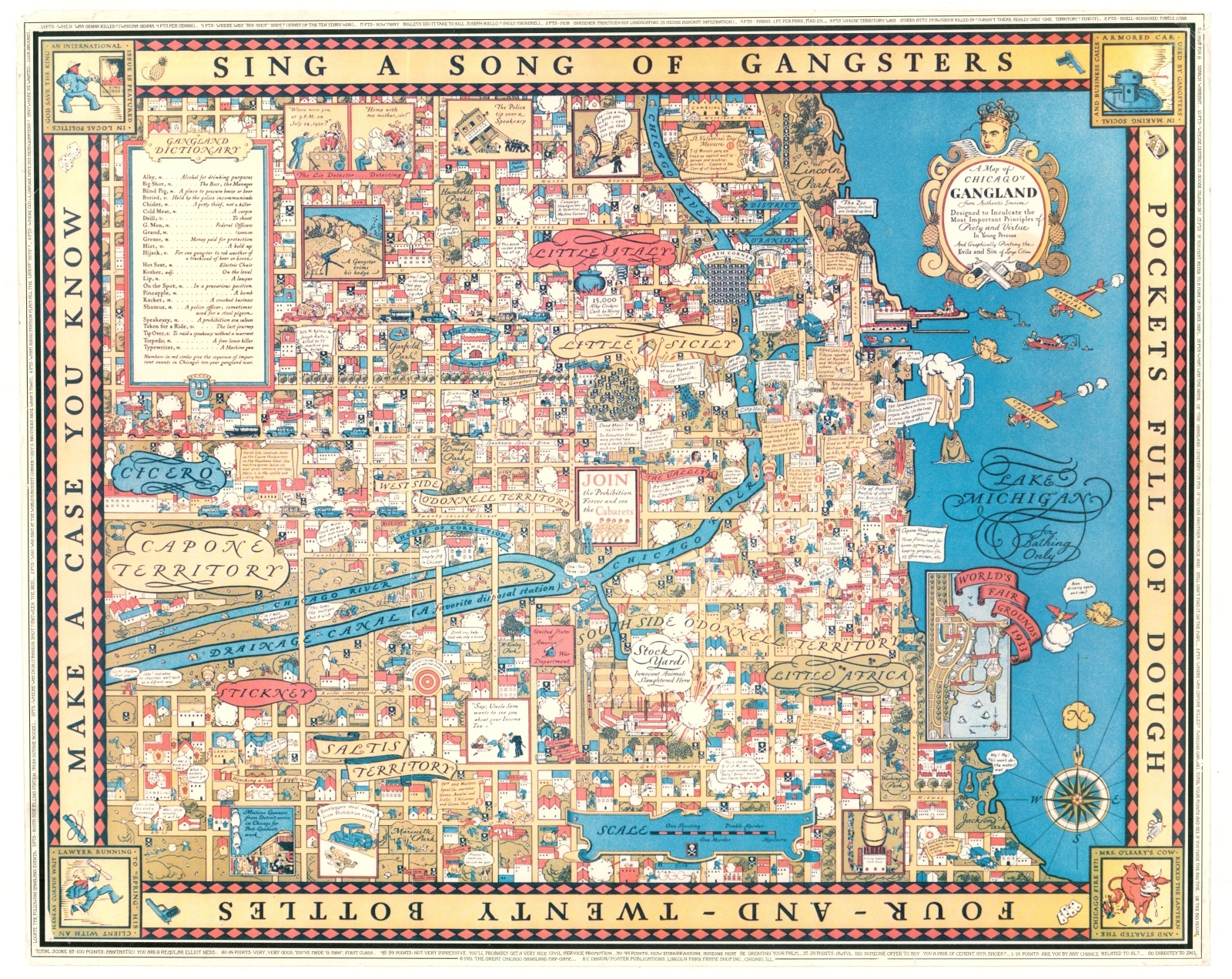
A Map of Chicago’s Gangland from Authentic Sources
Original price was: $750.00.$595.00Current price is: $595.00.
Later issue of one of the most stunning pictorial maps ever made.
1 in stock
Description
“SING A SONG OF GANGSTERS POCKETS FULL OF DOUGH FOUR-AND-TWENTY BOTTLES MAKE A CASE YOU KNOW” [Border text]
This tremendous pictorial image captures the myriad of characteristics that, even today, comprise much of Chicago’s identity as the former home of Al Capone and the Outfit. Elements of organized crime from bootlegging to prostitution are idealized within the whimsical borders with colorful illustrations, amusing captions, and cartoon characters. Numerous locations reference Capone, Prohibition (on its last legs at the time of original publication), and gang-related events across the city. Notable examples include the St. Valentine’s Day Massacre, Dead Man’s Tree, and Death Corner. Additional references in the distance scale, compass rose, corner vignettes, and the ‘Gangland Dictionary’ provide further generalizations and half-truths regarding Chicago’s lawlessness and crime.
The subtitle of the map reads, “Designed to Inculcate the Most Important Principles of Piety and Virtue in Young Persons And Graphically Portray the Evils and Sin of Large Cities.” Despite the upstanding claims, the content, especially the tongue-in-cheek humor, largely says otherwise. A vignette of the 1933 World’s Fair Grounds may indicate the true original purpose – to be sold as a souvenir for attendees at the Century of Progress.
The map, created anonymously, was originally published by Bruce-Roberts Inc. in 1931. According to Kevin Brown of Geographicus, the map was not popular among Chicago’s civic administrators, who were looking to shift the public’s perspective of the city to something more ‘family friendly’ for the upcoming World’s Fair. Mayor Anton Cermak led an effort to acquire and destroy as many copies as possible, making the originals quite scarce (and expensive) on the market today.
This example was published fifty years later after the original, by R.C. Danon and Poster Publications in Lincoln Park. It was reproduced as a type of board game, with questions referencing the map’s contents added to the outer border. Each comes with a corresponding point value, with the player keeping track of correct responses. Up to 100 points are possible, but it only takes 84 to qualify as a “regular Elliot Ness…” [see bottom]. Though this later printing lacks the clarity of the original, it remains an attractive re-imagining of one of the best pictorial maps ever made. Source: Rumsey 8984.000
Map Details
Publication Date: 1981
Author: R.C. Danon
Sheet Width (in): 28.5
Sheet Height (in): 23
Condition: B+
Condition Description: Professionally flattened and mounted on linen for preservation and stability. A bit of wear is visible along the outer edges, including pinholes in the corners and numerous small tears. Very good overall.
Original price was: $750.00.$595.00Current price is: $595.00.
1 in stock