A General Map of the World or Terraqueous Globe with All the New Discoveries and Marginal Delineations, Containing the Most Interesting Particulars in the Solar, Starry, and Mundane System
$5,000.00
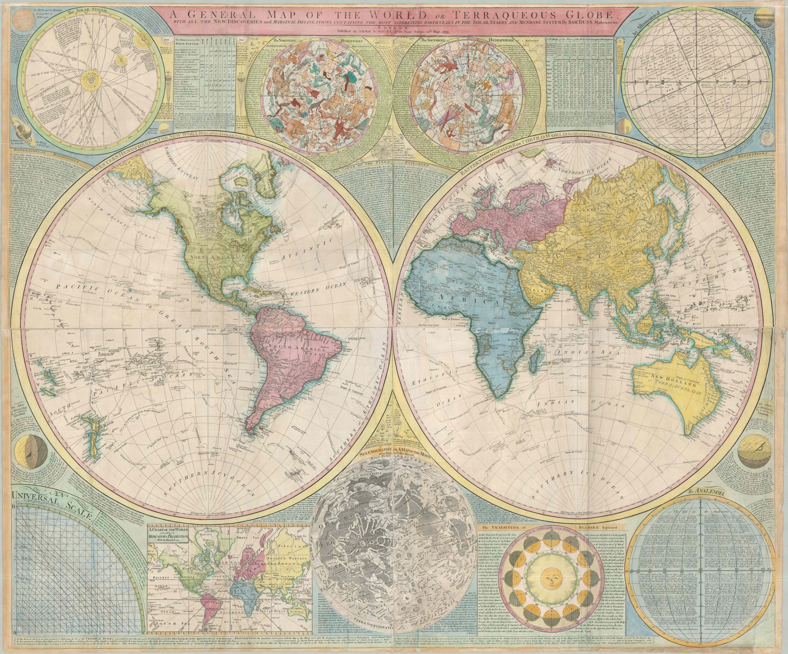
A stunning encapsulation of the Earth and the Heavens from the late 18th century.
1 in stock
Description
This expansive four-sheet copperplate engraving serves as a comprehensive visual encyclopedia of late 18th-century science. While the central focus is the twin hemispheres of the Earth, the map is distinguished by its incredible density of “Marginal Delineations.” Surrounding the world are finely engraved diagrams of the Solar, Starry, and Mundane Systems, including maps of the Moon, a chart of the seasons, and a representation of the solar system as it was understood just before the turn of the century.
Geographically, the map is a ledger of the new discoveries and colonial expansion that defined the era. The tracks of Captain Cook’s three voyages are prominently featured, alongside those of other explorers like Anson, Bouvet, and St. Allouran. The path of the famed Manila Galleons can also be traced across the Pacific. Newly mapped islands, updated coastlines in the Pacific Northwest and Australia (still labeled New Holland), and precise meridians and parallels present a delimited world, much of which would fall under the control of the British Empire by the end of the following century.
In spite of the author’s commitment to accuracy, there are a few interesting cartographic myths. The Mountains of the Moon, a relic of Ptolemy and the alleged source of the Nile, are prominently featured in an African interior that it otherwise quite sparse of toponyms. Though Baffin and Hudson’s Bays seem firmly closed to the west, there is the tempting possibility of a Northwest Passage (or significant shortcut) via Hearn and Mackenzie’s Outlets to the Sea’ in northern Canada. Several phantom or mislabeled islands dot the seas, including Saxemburg (South Atlantic) and St. Matthew (Gulf of Guinea).
The striking map, created by mathematician/teacher/engraver Samuel Dunn, first appeared in the 1770s as the centerpiece of the monumental New Atlas of the Mundane System. It was issued in several other volumes over approximately three decades, including those by Jefferys, Sayer & Bennett, and Laurie and Whittle. This example, issued by the last firm in London in 1799, is one of the final examples to appear – the plates were undoubtedly starting to show some wear!
Map Details
Publication Date: 1799
Author: Samuel Dunn/Thomas Kitchin/Laurie & Whittle
Sheet Width (in): 49.5
Sheet Height (in): 41.4
Condition: B+
Condition Description: Massive wall map comprised of four separate copperplate sheets adhered along overlapping seams, with some discoloration in the full hand color as a result (see Central Africa). There is also a bit of light dampstaining, likely from the application of the watercolor. Some old creasing where formerly folded and moderate marginal toning. A few spots of expert professional repairs, including marginal tears, a bit of color, and minor paper infill. Good to very good condition overall. An exceptionally attractive example, with a large custom frame available at extra cost (please inquire for details).
$5,000.00
1 in stock