
China Front
$450.00
An American perspective on events during the Second Sino-Japanese War.
1 in stock
Description
It can be argued that World War II did not start with Hitler’s invasion of Poland, but rather two years earlier, with the outbreak of the Second Sino-Japanese War. Despite initial successes and the capture of several key Chinese cities, including Beijing and Nanjing, Japanese forces were spread thin across the massive front and occupied territory. Western nations imposed harsh embargos in retaliation for the aggression, restricting further already limited access to natural resources, notably oil. This aided the arguments of pro-war factions in Japan, who considered conflict inevitable.
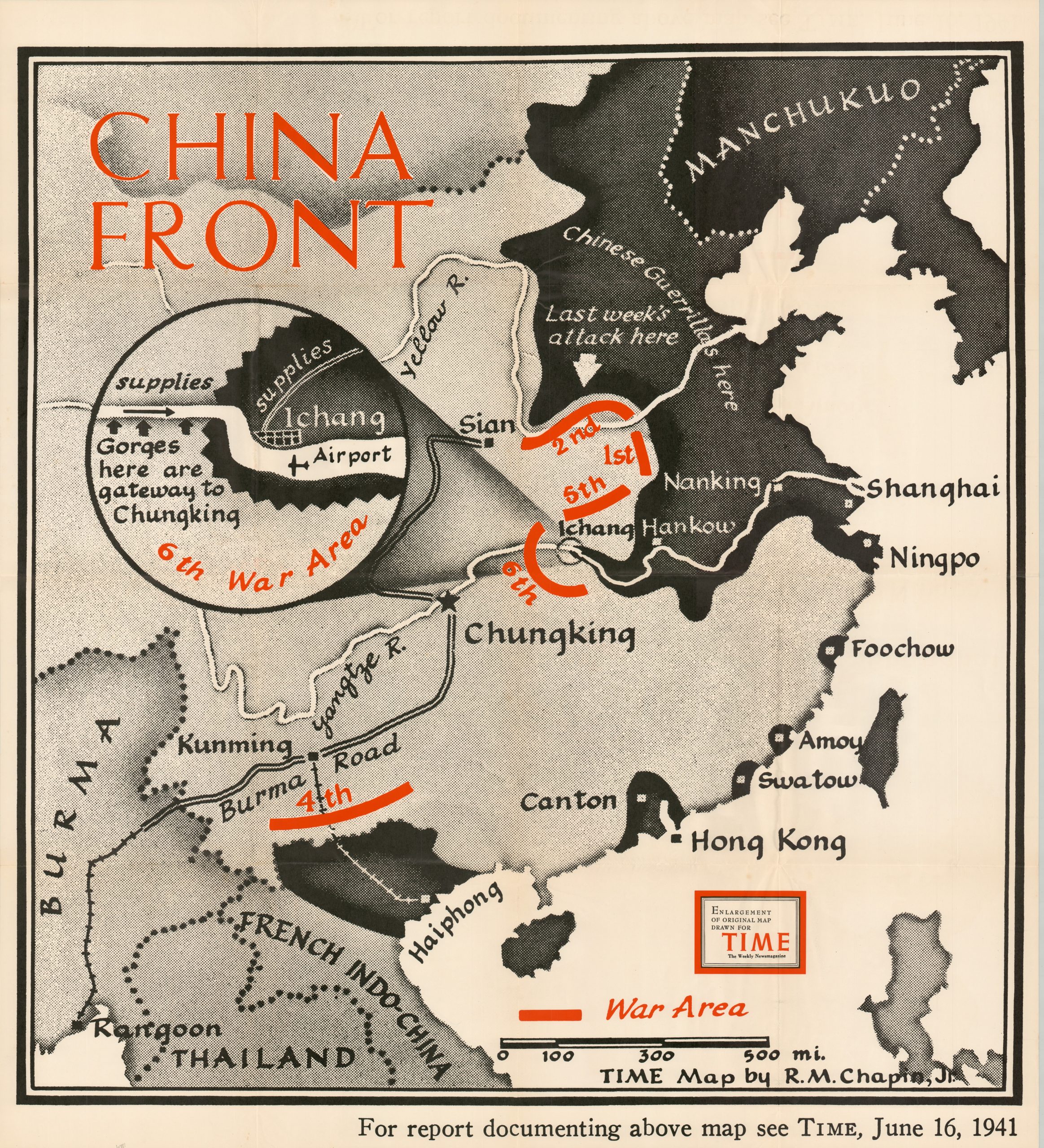
The image shows the war situation in China just six months before the attack on Pearl Harbor would turn the war truly global. Occupied territory is shaded in black, with the fighting concentrated at a bottleneck near Ichang. An inset map shows the airport, supply routes, and the gorges that are ‘the gateway to Chungking.’ Other areas of conflict are noted in red, including the protection of the critical Burma Road.
The map was designed by Robert M. Chapin, Jr. and published as a supplement for the June 16, 1941 issue of TIME Magazine. Chapin was a professionally trained architect who found jobs to be in low demand during the Great Depression. He took a job in the photo department at Newsweek in 1933, where he apparently picked up a knack for cartographic design. By 1937, he was hired by Time (a rival of Newsweek) as the head of the cartography department, a position he would hold until his retirement in 1970.
During his long tenure at Time, Chapin’s prolific output helped establish a pattern for 20th century newsroom cartography. The use of bold colors, uncluttered design, and legible typography was immensely popular, and the maps were reprinted for distribution in classrooms and public spaces throughout the country. Despite their widespread appeal, the maps are uncommon on the market and often overlooked in institutional collections. This version is listed in only three examples in WorldCat as of May 2024 – Franklin & Marshall College, the Library of Congress, and the University of Illinois at Urbana-Champaign. OCLC# 30368252; TIME Magazine
Map Details
Publication Date: 1941
Author: Robert M. Chapin, Jr.
Sheet Width (in): 35
Sheet Height (in): 38.5
Condition: A
Condition Description: Creasing, light wear, and some wrinkling along originally issued fold lines. Near fine condition overall. Blank on verso.
$450.00
1 in stock