U.S. Midwest
Showing 505–522 of 1692 resultsSorted by latest
-

A Map of the Middle States of America
$3,400.00 Quick View -
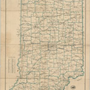
Post Route Map of the State of Indiana
$95.00 Quick View -
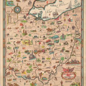
Friendly Service Map of the Commonwealth of Ohio
$150.00 Quick View -
[Parts of Missouri and Kansas during the American Civil War]
$75.00 Quick View -
[Parts of Missouri, Kansas, Arkansas, and Indian Territory during the American Civil War]
$75.00 Quick View -
[Parts of Missouri, Arkansas, Tennessee, Kentucky, and Illinois during the American Civil War]
$75.00 Quick View -
[Parts of Missouri and Illinois during the American Civil War]
$75.00 Quick View -
[Parts of Illinois, Indiana, Kentucky, and Ohio during the American Civil War]
$75.00 Quick View -
[Parts of Kentucky and Tennessee during the American Civil War]
$75.00 Quick View -
[Parts of West Virginia, Ohio, Pennsylvania, and Kentucky during the American Civil War]
$75.00 Quick View -
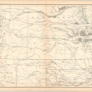
Map of the States of Kansas and Texas and Indian Territory, with parts of the Territories of Colorado and New Mexico
$75.00 Quick View -
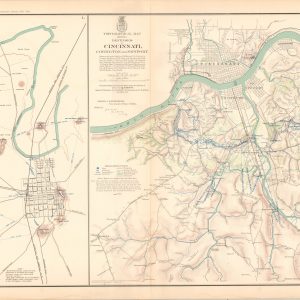
Map of Bowling Green, Ky. Showing its Approaches and Defenses; Topographical Map Showing Defenses of Cincinnati, Covington, and Newport
Quick View -
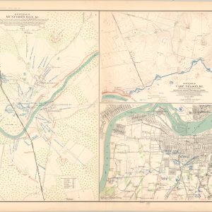
Defenses of Munfordville, Ky.; Defenses of Camp Nelson, Ky.; Louisville and its Defenses
$75.00 Quick View -
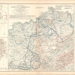
Battle-Field of Baton Rouge, La.; Campaigns in which the Army of the Cumberland Took Part…; Battle-Field of Perryville, Ky.
$75.00 Quick View -
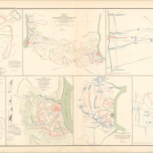
Plan of Fort Henry and its Outworks; Military Map of the Country Between the Tennessee and Cumberland; Plan of Fort Donelson and its Outworks;
$75.00 Quick View -
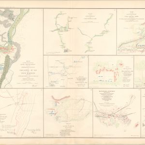
Map Showing the System of Rebel Fortifications on the Mississippi River at Island No. 10; Plan of the Battlefield of Pea Ridge, Arkansas; Sketch of Battlefield at Shiloh;
$75.00 Quick View -
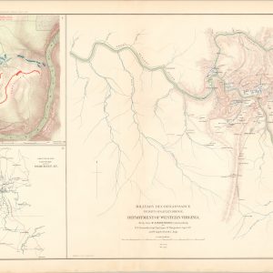
Military Reconnaissance, Vicinity of Gauley Bridge, Western Va.; Map of the Battlefield of Carnifix Ferry; Sketch of the Country around Somerset, Ky.
$75.00 Quick View -
Defenses of Washington; Sketch of Paducah, Ky. and Vicinity; Sketch of the Battle-Field of Logan’s Cross-Roads, Ky.
$75.00 Quick View

![[Parts of Missouri and Kansas during the American Civil War]](https://curtiswrightmaps.com/wp-content/uploads/map_29.14x18.11_07-19-24_plate_clxi-300x300.jpg)
![[Parts of Missouri, Kansas, Arkansas, and Indian Territory during the American Civil War]](https://curtiswrightmaps.com/wp-content/uploads/map_28.95x18.23_07-19-24_plate_clx-300x300.jpg)
![[Parts of Missouri, Arkansas, Tennessee, Kentucky, and Illinois during the American Civil War]](https://curtiswrightmaps.com/wp-content/uploads/map_29.07x18.17_07-19-24_plate_cliii-300x300.jpg)
![[Parts of Missouri and Illinois during the American Civil War]](https://curtiswrightmaps.com/wp-content/uploads/map_28.96x18.13_07-19-24_plate_clii-300x300.jpg)
![[Parts of Illinois, Indiana, Kentucky, and Ohio during the American Civil War]](https://curtiswrightmaps.com/wp-content/uploads/map_29.16x18.15_07-19-24_plate_cli-300x300.jpg)
![[Parts of Kentucky and Tennessee during the American Civil War]](https://curtiswrightmaps.com/wp-content/uploads/map_28.92x18.11_07-19-24_plate_cl-300x300.jpg)
![[Parts of West Virginia, Ohio, Pennsylvania, and Kentucky during the American Civil War]](https://curtiswrightmaps.com/wp-content/uploads/map_28.91x18.17_07-19-24_plate_cxl-300x300.jpg)