Westinghouse Strategic War Map
$250.00
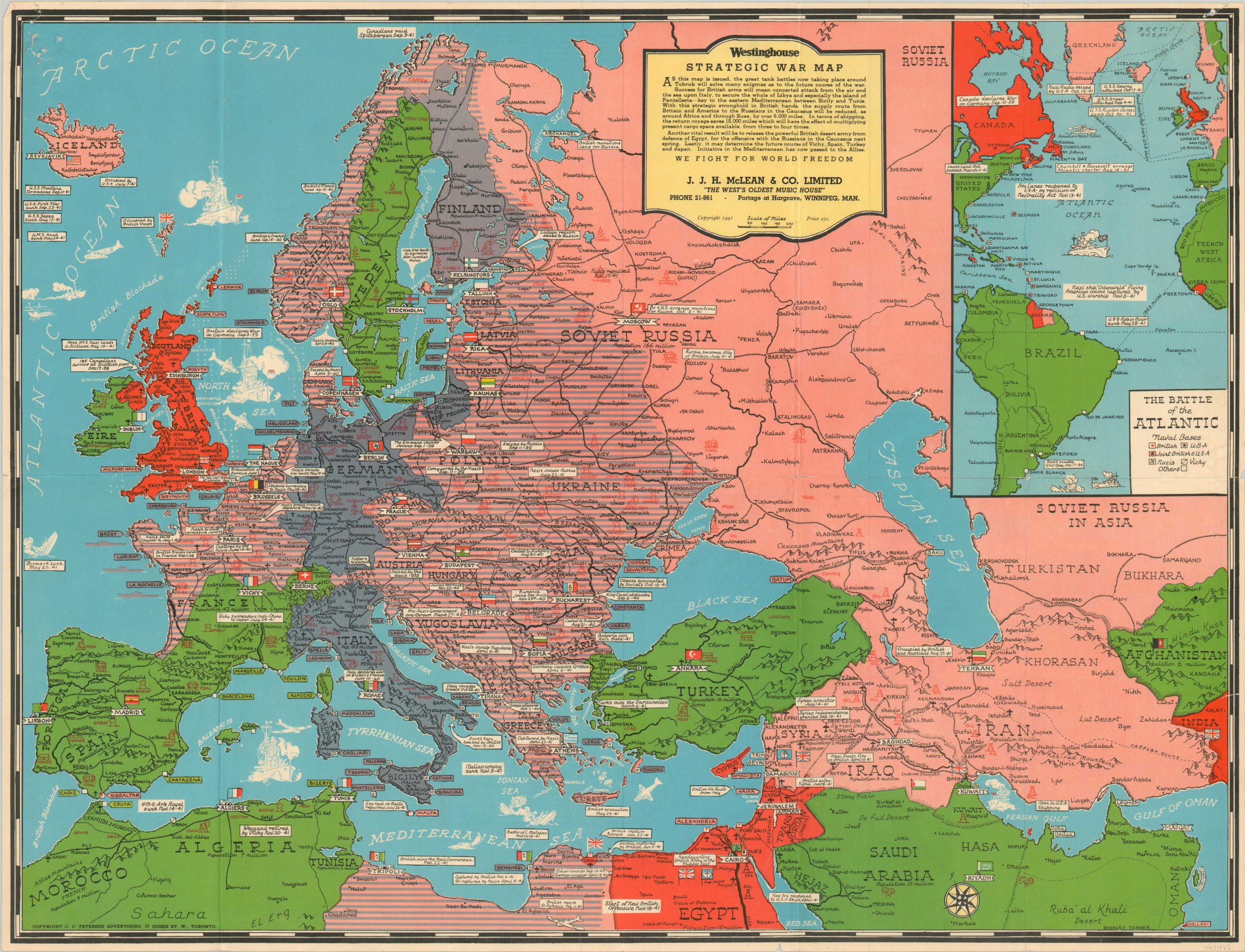
One of the earliest versions of Stanley Turner’s Strategic War Maps – issued shortly after the U.S. Declaration of War.
1 in stock
Description
This scarce map showing the status of the European theater of war in late 1941 was one of the first in a series that would later be called “Dated Event War Maps.” Drawn by artist Stanley Turner and variously licensed or published by C.C. Petersen of Toronto, the group of maps chronicled major events of World War Two using a similar color scheme, supplemented by dated annotations of major events.
This particular example was issued in December of 1941, shortly after the United States declared war on Japan and shows the current situation across Europe, Russia, the Middle East, and North Africa. The image is bleak.
France was nominally an ally of the Nazi regime, though Vichy territory is colored as neutral (green). An inset in the upper left shows includes several casualties from the ongoing Battle of the Atlantic, where U-Boats attempted to starve Britain into submission.
Territory under German control extends nearly to the gates of Moscow and into Libya, where the ongoing siege of Tobruk is highlighted with the red of the British Empire. The last dated event on the image can be seen immediately below – “Start of New British Offensive Nov. 18-41”. This campaign, known as Operation Crusader, would eventually be successful in forcing Rommel’s Afrika-Korps to retreat and relieved the port city later that same month.
The verso is also of interest, and is emblematic of the serialized nature of the maps’ publication as the war progressed. This side shows the earliest version of Turner’s ‘Strategic War Map of the Pacific’, drawn just days after the attack on Pearl Harbor.
Accompanying text reads “As the world now knows, this typical Fascist attack by Nazis of Japan has united the entire English-speaking peoples of all continents in the cause of World Freedom. The heroic sacrifices, fortitude, and courage of the British, Russian, and other liberty-loving people of the world must not be in vain. To this end each one of us must dedicate his or her comfort, position, possessions, and even life itself.”
For more information on Stanley Turner’s Dated Events Maps, check out my blog post here.
Map Details
Publication Date: 1941
Author: Stanley Turner
Sheet Width (in): 26.10
Sheet Height (in):
Condition: B
Condition Description: Originally issued folded into 10 panels, with moderate creasing and wear along fold lines. Small separation at fold intersections, and pinholes in the corners has resulted in minor image loss.
$250.00
1 in stock

