Empire
Maps which show the territorial extent of historic empires.
Showing 1–18 of 775 results
-

[First Sino-Japanese War Cloth Map]
$2,200.00 Quick View -

A Pictorial Map of Palo Alto and the San Francisco Peninsula
$545.00 Quick View -
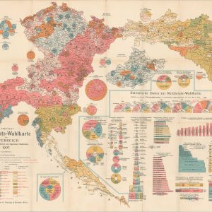
Reichsrats-Wahlkarte von Osterreich auf Grundlage des gleichen und allgemeinen Wahlrechtes [Electoral Map of Austria]
$275.00 Quick View -

An Historical Map of Texas Beginning with the Spanish Explorations
$325.00 Quick View -

Table Theodosienne dite Carte de Peutinger
$125.00 Quick View -

Nouvelle Carte Heraldique des Rois d’Espagne…
$195.00 Quick View -

Carte du Gouvernement de l’Amerique
$195.00 Quick View -

Carte d’Espagne et des Principaux Etats Appartenans a Cette Monarchie dans les 4 Parties du Monde
$225.00 Quick View -
Delineatio Regionis Bassora…
$165.00 Quick View -

Carte de L’Itineraire Suivi par M. Le Comte de Tinseau [Cambodia]
$85.00 Quick View -

Synchronoptische Weltgeschichte [Synchronoptical World History]
$110.00 Quick View -
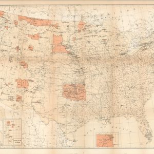
Map Showing the Location of the Indian Reservations within the Limits of the United States and Territories
$175.00 Quick View -

Bugella Civitas [Italy]
$225.00 Quick View -
 Sold Out
Vue du Palais des Tuileries du cote du Jardin
Quick View -

Sancti Damiani Oppidum
$165.00 Quick View -

Carte Reduite de L’Isle D’Antigue [Island of Antigua]
$475.00 Quick View -

Nebraska and Kansas
$5,250.00 Quick View -
 Sold Out
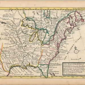
A New map of ye North Parts of America Claimed by France…
Quick View
show blocks helper